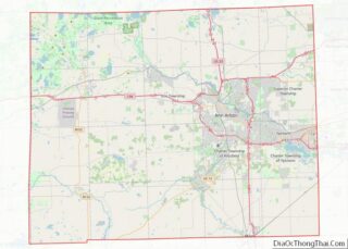
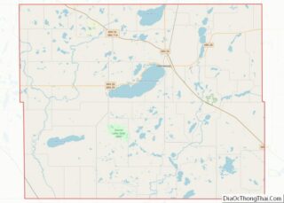
Map of Santa Clara County, California
Santa Clara County, officially the County of Santa Clara, is the sixth-most populous county in the U.S. state of California, with a population of 1,936,259, as of the 2020 census. Santa Clara County and neighboring San Benito County together form the U.S. Census Bureau’s San Jose-Sunnyvale-Santa Clara metropolitan statistical area, which is part of the ... Read more
Map of Santa Clara County, California
Map of Adams County, Colorado
Adams County is a county located in the U.S. state of Colorado. As of the 2020 census, the population was 519,572. The county seat is Brighton. The county is named for Alva Adams, an early Governor of the State of Colorado in 1887–1889. Adams County is part of the Denver–Aurora–Lakewood, CO Metropolitan Statistical Area. Adams ... Read more
Map of Adams County, Colorado
Map of Denver County, Colorado
Denver (/ˈdɛnvər/) is a consolidated city and county, the capital, and most populous city of the U.S. state of Colorado. Its population was 715,522 at the 2020 census, a 19.22% increase since 2010. It is the 19th-most populous city in the United States and the fifth most populous state capital. It is the principal city ... Read more
Map of Denver County, Colorado
Map of Kit Carson County, Colorado
Kit Carson County is a county located in the U.S. state of Colorado. As of the 2020 census, the population was 7,087. The county seat is Burlington. The county was established in 1889 and named for American frontiersman and Indian fighter Kit Carson. Kit Carson County overview: Name: Kit Carson County FIPS code: 08-063 State: ... Read more
Map of Kit Carson County, Colorado
Map of Phillips County, Colorado
Phillips County is a county located in the U.S. state of Colorado. As of the 2020 census, the population was 4,530. The county seat is Holyoke. The county was named in honor of R.O. Phillips, a secretary of the Lincoln Land Company, who organized several towns in Colorado. Phillips County overview: Name: Phillips County FIPS ... Read more
Map of Phillips County, Colorado
Map of Fairfield County, Connecticut
Fairfield County is a county in the southwestern corner of the U.S. state of Connecticut. It is the most populous county in the state and was also its fastest-growing from 2010 to 2020. As of the 2020 census, the county’s population was 957,419, representing 26.6% of Connecticut’s overall population. The closest to the center of ... Read more
Map of Fairfield County, Connecticut
Map of Brevard County, Florida
Brevard County (/brəˈvɑːrd/ brə-VARD) is a county located in the east central portion of the U.S. state of Florida. As of the 2020 census, the population was 606,612, making it the 10th-most populated county in Florida. The official county seat is located in Titusville. Brevard County comprises the Palm Bay–Melbourne–Titusville, FL Metropolitan Statistical Area. It ... Read more
Map of Brevard County, Florida
Map of Glades County, Florida
Glades County is a county located in the Florida Heartland region of the U.S. state of Florida. As of the 2020 census, the population was 12,126, making it the fourth-least populous county in Florida. Its county seat is Moore Haven. Glades County overview: Name: Glades County FIPS code: 12-043 State: Florida Founded: April 23, 1921 ... Read more
Map of Glades County, Florida
Map of Levy County, Florida
Levy County overview: Name: Levy County FIPS code: 12-075 State: Florida Founded: March 10, 1845 Named for: David Levy Yulee Seat: Bronson Largest city: Williston Total Area: 1,413 sq mi (3,660 km²) Land Area: 1,118 sq mi (2,900 km²) Total Population: 42,915 Population Density: 38/sq mi (15/km²) Time zone: UTC−5 (Eastern) Summer Time Zone (DST): UTC−4 (EDT) Website: www.levycounty.org Levy County location ... Read more
Map of Levy County, Florida
Map of Polk County, Florida
Polk County is located in the central portion of the U.S. state of Florida. The county population was 725,046, as of the 2020 census. Its county seat is Bartow, and its largest city is Lakeland. Polk County comprises the Lakeland–Winter Haven Metropolitan Statistical Area. This MSA is the 81st-most populous metropolitan statistical area and the ... Read more
Map of Polk County, Florida
Map of Atkinson County, Georgia
Atkinson County is a county located in the southeastern portion of the U.S. state of Georgia. As of the 2020 census, the population was 8,286. The county seat is Pearson. The county was formed in 1917 from parts of Coffee and Clinch Counties. It is named for William Yates Atkinson, Democratic governor of Georgia from ... Read more
Map of Atkinson County, Georgia
Map of Butts County, Georgia
Butts County is a county located in the central part of the U.S. state of Georgia. As of the 2020 census, the population was 25,434, up from 23,655 in 2010. The county seat is Jackson. The county was created on December 24, 1825. Butts County is included in the Atlanta-Sandy Springs-Roswell, GA Metropolitan Statistical Area. ... Read more
Map of Butts County, Georgia