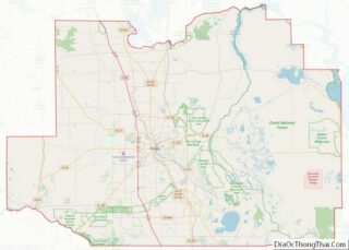
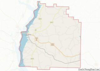
Kimball County is a county in the U.S. state of Nebraska. As of the 2010 United States Census, the population was 3,821. Its county seat is Kimball. The county was formed in 1888 and named after railroad pioneer Thomas Lord Kimball. In the Nebraska license plate system, Kimball County is represented by the prefix 71 ... Read more
Map of US Counties
Phelps County is a county in the U.S. state of Nebraska. As of the 2010 United States Census, the population was 9,188. Its county seat is Holdrege. The county was formed in 1873, and was named for William Phelps (1808–1889), a steamboat captain and early settler. In the Nebraska license plate system, Phelps County is ... Read more
Thayer County is a county in the U.S. state of Nebraska. As of the 2020 United States Census, the population was 5,034. The county was created in 1856 and originally named Jefferson County. It was organized in 1870-1871 and renamed for General and Governor John Milton Thayer. In the Nebraska license plate system, Thayer County ... Read more
Humboldt County is a county in the U.S. state of Nevada. As of the 2020 Census, the population was 17,285. It is a largely rural county that is sparsely populated with the only major city being Winnemucca which has a population of 8,431. Humboldt County comprises the Winnemucca, NV Micropolitan Statistical Area and serves as ... Read more
Merrimack County is a county in the U.S. state of New Hampshire. As of the 2020 Census, the population was 153,808, making it the third-most populous county in New Hampshire. Its county seat is Concord, the state capital. The county was organized in 1823 from parts of Hillsborough and Rockingham counties, and is named for ... Read more
Monmouth County overview: Name: Monmouth County FIPS code: 34-025 State: New Jersey Founded: 1683 Named for: Monmouthshire Seat: Freehold Borough Largest city: Middletown Township (population)Howell Township (area) Total Area: 665.32 sq mi (1,723.2 km²) Land Area: 468.79 sq mi (1,214.2 km²) Total Population: 643,615 Population Density: 1,372.9/sq mi (530.1/km²) Website: www.co.monmouth.nj.us Monmouth County location map. Where is Monmouth County? History Etymology The ... Read more
Doña Ana County (Spanish: Condado de Doña Ana) is located in the southern part of the State of New Mexico, United States. As of the 2020 U.S. Census, its population was 219,561, which makes it the second-most populated county in New Mexico. Its county seat is Las Cruces, the second-most populous municipality in New Mexico ... Read more
San Juan County overview: Name: San Juan County FIPS code: 35-045 State: New Mexico Founded: February 24, 1887 Named for: San Juan River Seat: Aztec Largest city: Farmington Total Area: 5,538 sq mi (14,340 km²) Land Area: 5,513 sq mi (14,280 km²) Total Population: 121,661 Population Density: 24/sq mi (9/km²) Time zone: UTC−7 (Mountain) Summer Time Zone (DST): UTC−6 (MDT) Website: www.sjcounty.net ... Read more
Chautauqua County is the westernmost county in the U.S. state of New York. As of the 2020 census, the population was 127,657. Its county seat is Mayville, and its largest city is Jamestown. Its name is believed to be the lone surviving remnant of the Erie language, a tongue lost in the 17th century Beaver ... Read more
Jefferson County is a county on the northern border of the U.S. state of New York. As of the 2020 census, the population was 116,721. Its county seat is Watertown. The county is named after Thomas Jefferson, third President of the United States of America. It is adjacent to Lake Ontario, southeast from the Canada–US ... Read more
Oswego County is a county in the U.S. state of New York. As of the 2020 census, the population was 117,525. The county seat is Oswego. The county name is from a Mohawk-language word meaning “the pouring out place”, referring to the point at which the Oswego River feeds into Lake Ontario at the northern ... Read more
Tioga County /taɪˈoʊɡə/ is a county in the U.S. state of New York. As of the 2020 census, the population was 48,455. Its county seat is Owego. Its name derives from an American Indian word meaning “at the forks”, describing a meeting place. Tioga County is part of the Binghamton, NY Metropolitan Statistical Area. Tioga ... Read more