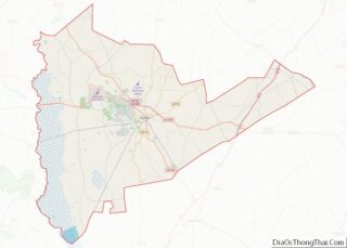
Map of Lawrence County, Alabama
Lawrence County is a county in the northern part of the U.S. state of Alabama. As of the 2020 census, the population was 33,073. The county seat is Moulton. The county was named after James Lawrence, a captain in the United States Navy from New Jersey. Lawrence County is included in the Decatur, AL Metropolitan ... Read more
Map of Lawrence County, Alabama
Map of Randolph County, Alabama
Randolph County is a county on the central eastern border of the U.S. state of Alabama. As of the 2020 census, the population was 21,967. Its county seat is Wedowee. Its name is in honor of John Randolph, a member of the United States Senate from Virginia. Randolph County was a prohibition or dry county ... Read more
Map of Randolph County, Alabama
Map of Bristol Bay Borough, Alaska
Bristol Bay Borough is a borough of the U.S. state of Alaska on Bristol Bay. As of the 2020 census the borough population was 844, down from 997 in 2010, the second-least populated borough in Alaska. The borough seat is Naknek. There are no incorporated settlements. Incorporated in 1962, Bristol Bay was the first of ... Read more
Map of Bristol Bay Borough, Alaska
Map of Skagway Municipality, Alaska
The Municipality and Borough of Skagway is a first-class borough in Alaska on the Alaska Panhandle. As of the 2020 census, the population was 1,240, up from 968 in 2010. The population doubles in the summer tourist season in order to deal with more than 1,000,000 visitors each year. Incorporated as a borough on June ... Read more
Map of Skagway Municipality, Alaska
Map of Pima County, Arizona
Pima County overview: Name: Pima County FIPS code: 04-019 State: Arizona Founded: November 9, 1864 Named for: Pima people Seat: Tucson Largest city: Tucson Total Area: 9,189 sq mi (23,800 km²) Land Area: 9,187 sq mi (23,790 km²) Total Population: 1,043,433 Population Density: 110/sq mi (44/km²) Time zone: UTC−7 (Mountain) Website: www.pima.gov Pima County location map. Where is Pima County? History Pima ... Read more
Map of Pima County, Arizona
Map of Cleburne County, Arkansas
Cleburne County is a county located in the U.S. state of Arkansas. As of the 2020 census, the population was 24,711. The county seat and most populous city is Heber Springs. The county was formed on February 20, 1883, as the last of Arkansas’s 75 counties to be formed. It is named for Confederate Major-General ... Read more
Map of Cleburne County, Arkansas
Map of Greene County, Arkansas
Greene County is a county located in the U.S. state of Arkansas. As of the 2020 census, the population was 45,736. The county seat is Paragould, which sits atop Crowley’s Ridge. Greene County is included in Jonesboro–Paragould Combined Statistical Area. Greene County overview: Name: Greene County FIPS code: 05-055 State: Arkansas Founded: November 5, 1833 ... Read more
Map of Greene County, Arkansas
Map of Madison County, Arkansas
Madison County is a county located in the U.S. state of Arkansas. As of the 2020 census, the population was 16,521. The county seat is Huntsville. The county was formed on September 30, 1836, and named for Madison County, Alabama, the home of some early settlers. They also named the county seat after Madison County ... Read more
Map of Madison County, Arkansas
Map of Pulaski County, Arkansas
Pulaski County is a county in the U.S. state of Arkansas. With a population of 399,125 as of the 2020 United States Census, it is the most populous county in Arkansas. The county is included in the Little Rock–North Little Rock–Conway metropolitan area. Its county seat is Little Rock, which is also Arkansas’s capital and ... Read more
Map of Pulaski County, Arkansas
Map of Alameda County, California
Alameda County (/ˌæləˈmiːdə/ (listen) AL-ə-MEE-də) is a county located in the U.S. state of California. As of the 2020 census, the population was 1,682,353, making it the 7th-most populous county in the state and 21st most populous nationally. The county seat is Oakland. Alameda County is in the San Francisco Bay Area, occupying much of ... Read more
Map of Alameda County, California
Map of Lake County, California
Lake County is a county located in the north central portion of the U.S. state of California. As of the 2020 census, the population was 68,163. The county seat is Lakeport. The county takes its name from Clear Lake, the dominant geographic feature in the county and the largest non-extinct natural lake wholly within California. ... Read more
Map of Lake County, California
Map of Riverside County, California
Riverside County is a county located in the southern portion of the U.S. state of California. As of the 2020 census, the population was 2,418,185, making it the fourth-most populous county in California and the 10th-most populous in the United States. The name was derived from the city of Riverside, which is the county seat. ... Read more
Map of Riverside County, California