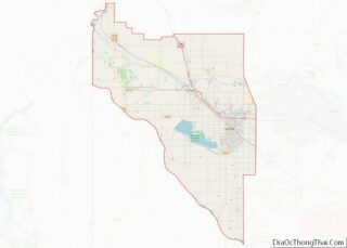
Map of Stanislaus County

Map of Stanislaus County, California

Stanislaus County (/ˈstænɪslɔː(s)/ (listen); Spanish: Condado de Estanislao) is a county located in the San Joaquin Valley of the U.S. state of California. As of the 2020 census, the population was 552,878. The county seat is Modesto. Stanislaus County makes up the Modesto Metropolitan Statistical Area. The county is located just east of the San … Read more

Map of Broomfield City And County

Map of Broomfield County, Colorado

Broomfield is a consolidated city and county located in the U.S. state of Colorado. Broomfield has a consolidated government which operates under Article XX, Sections 10-13 of the Constitution of the State of Colorado. The Broomfield population was 74,112 at the 2020 United States Census, making it the 15th most populous municipality and the 12th … Read more

Map of Garfield County

Map of Garfield County, Colorado

Garfield County is a county located in the U.S. state of Colorado. As of the 2020 census, the population was 61,685. The county seat is Glenwood Springs. The county is named in honor of United States President James A. Garfield. Garfield County is included in the Glenwood Springs, CO Micropolitan Statistical Area, which is also … Read more

Map of Mesa County

Map of Mesa County, Colorado

Mesa County overview: Name: Mesa County FIPS code: 08-077 State: Colorado Founded: February 14, 1883 Named for: Mesas in the area Seat: Grand Junction Largest city: Grand Junction Total Area: 3,341 sq mi (8,650 km²) Land Area: 3,329 sq mi (8,620 km²) Total Population: 157,335 Population Density: 47/sq mi (18/km²) Time zone: UTC−7 (Mountain) Summer Time Zone (DST): UTC−6 (MDT) Website: www.mesacounty.us … Read more

Map of Saguache County

Map of Saguache County, Colorado

Saguache County (suh-WATCH /səˈwɑːtʃ/ (listen)) is a county located in the U.S. state of Colorado. As of the 2020 census, the population was 6,368. The county seat is Saguache. Saguache County overview: Name: Saguache County FIPS code: 08-109 State: Colorado Founded: December 29, 1866 Seat: Saguache Largest town: Center Total Area: 3,170 sq mi (8,200 km²) Land Area: … Read more

Map of Windham County

Map of Windham County, Connecticut

Windham County overview: Name: Windham County FIPS code: 09-015 State: Connecticut Founded: May 12, 1726 Named for: Windham, England Seat: none (1960-present) Willimantic (1893-1960) Windham (1726-1893) Largest town: Windham Total Area: 521 sq mi (1,350 km²) Land Area: 513 sq mi (1,330 km²) Total Population: 116,418 Population Density: 223.5/sq mi (86.3/km²) Time zone: UTC−5 (Eastern) Summer Time Zone (DST): UTC−4 (EDT) Windham … Read more

Map of Columbia County

Map of Columbia County, Florida

Columbia County is a county located in the north central portion of the U.S. state of Florida. As of the 2020 census, the population was 69,698, up from 67,531 at the 2010 census. Its county seat is Lake City. Columbia County comprises the Lake City, FL Micropolitan Statistical Area, which is included in the Gainesville-Lake … Read more

Map of Hillsborough County

Map of Hillsborough County, Florida

Hillsborough County is located in the west central portion of the U.S. state of Florida. In the 2020 census, the population was 1,459,762, making it the fourth-most populous county in Florida and the most populous county outside the Miami metropolitan area. A 2021 estimate has the population of Hillsborough County at 1,512,070 people with a … Read more

Map of Monroe County

Map of Monroe County, Florida

Monroe County is a county in the state of Florida. As of the 2020 census, the population was 82,874. Its county seat is Key West. Monroe County includes the islands of the Florida Keys and comprises the Key West Micropolitan Statistical Area. Over 99.9% of the county’s population lives on the Florida Keys. The mainland, … Read more

Map of Sumter County

Map of Sumter County, Florida

Sumter County is a county located in the central portion of the U.S. state of Florida. As of the 2020 census, the population is 129,752. It has the oldest median age (68.3 years) of any US county and the highest percentage of residents aged 65 and older—at 55.6% in 2014-2018 (in 2009–2013). Its county seat … Read more

Map of Ben Hill County

Map of Ben Hill County, Georgia

Ben Hill County is a county located in the U.S. state of Georgia. As of the 2020 census, the population was 17,194. The county seat is Fitzgerald. The county was organized in 1906. It is named after Benjamin Harvey Hill, a former Confederate and United States Senator. Ben Hill County comprises the Fitzgerald, Georgia, Micropolitan … Read more

Map of Chatham County

Map of Chatham County, Georgia

Chatham County (/ˈtʃætəm/ CHAT-əm) is located in the U.S. state of Georgia, on the state’s Atlantic coast. The county seat and largest city is Savannah. One of the original counties of Georgia, Chatham County was created February 5, 1777, and is named after William Pitt, 1st Earl of Chatham. The U.S. Census Bureau’s official 2020 … Read more