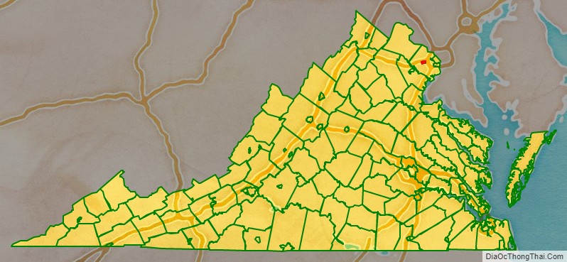
The City of Fairfax (/ˈfɛərfæks/ FAIR-faks), colloquially known as Fairfax City, Downtown Fairfax, Old Town Fairfax, Fairfax Courthouse, FFX, or simply Fairfax, is an independent city in the Commonwealth of Virginia in the United States. At the 2010 census the population was 22,565, which had risen to 24,146 at the 2020 census.
The City of Fairfax is an enclave surrounded by the separate political entity Fairfax County. Fairfax City also contains an exclave of Fairfax County, the Fairfax County Court Complex.
The City of Fairfax and the area immediately surrounding the historical border of the City of Fairfax, collectively designated by Fairfax County as “Fairfax”, comprise the county seat of Fairfax County. The city is part of the Washington metropolitan area as well as a part of Northern Virginia. The city is 14 miles (23 km) west of Washington, D.C. The Washington Metro’s Orange Line serves Fairfax through its Vienna station, which is a mile northeast of the city limits. CUE Bus and Metrobus operate in Fairfax. Virginia Railway Express’s Burke Centre station is situated three miles southeast of the city’s boundaries. Virginia’s largest public educational institution with 35,189 students in 2017 is George Mason University, which is located in unincorporated Fairfax County, along the city’s southern border while still having a City of Fairfax address and sharing the same public transportation system.
| Name: | Fairfax City |
|---|---|
| FIPS code: | 51-600 |
| State: | Virginia |
| Founded: | 1869 |
| Total Area: | 6.27 sq mi (16.25 km²) |
| Land Area: | 6.24 sq mi (16.16 km²) |
| Total Population: | 24,146 |
| Population Density: | 3,900/sq mi (1,500/km²) |
Fairfax City location map. Where is Fairfax City?
History
Fairfax was founded on land originally occupied by indigenous people of the Siouan and Iroquoian tribes. The city derives its name from Thomas Fairfax, 6th Lord Fairfax of Cameron, who was awarded 5,000,000 acres (20,000 km) of land in northern Virginia by King Charles. The area that the city now encompasses was settled in the early 18th century by farmers from Virginia’s Tidewater region. The town of “Providence” was established on the site by an act of the state legislature in 1805.
The scene of the first land battle of the Civil War, the Battle of Fairfax Court House took place here on June 1, 1861, after a Union scouting party clashed with the local militia with neither side gaining advantage. A second battle took place here two years later on June 27, 1863, where Union troops were defeated. This battle delayed the movements of Confederate cavalry chief Jeb Stuart with disastrous consequences for Lee at Gettysburg a few days later.
Fairfax was officially renamed the “Town of Fairfax” in 1859. It was incorporated as a town in 1874. It was incorporated as a city in 1961 by court order. Under Virginia law the city was separated from Fairfax County yet remains the county seat. In 1904, a trolley line connected Fairfax with Washington, D.C.
Architecture
The former Fairfax County Courthouse is the oldest historic building in Fairfax. The first Fairfax courthouse was established in 1742 near present-day Tysons Corner, and is the namesake for Old Courthouse Road. It intersects with Gallows Road, which today is a major commuter route, but at the time was the road where condemned prisoners were led to the gallows at the old courthouse. In 1752, the courthouse was moved to Alexandria, which offered to build the new courthouse at their own expense. The reason the courthouse was moved from the Tysons Corner location was because of “Indian hostilities”, as noted on the stone marker at the northwest corner of Gallows Road and Route 123. The courthouse operated there until 1790, when Virginia ceded the land where the courthouse was located for the creation of Washington, DC. The General Assembly specified that the new courthouse should be located in the center of the county, and was established at the corner of what was Old Little River Turnpike and is now Main Street and what was Ox Road and is now Chain Bridge Road on land donated by town founder Richard Ratcliffe. The courthouse changed hands repeatedly during the Civil War, and the first Confederate officer battle casualty, John Quincy Marr, occurred on its grounds. The first meeting of the Fairfax Court was held April 21, 1800.
The oldest two-story building in the city, the Fairfax Public School was built in 1873 for $2,750. In addition to elementary school use the building has also housed special education, adult education, and police academy training. On July 4, 1992, the building became the Fairfax Museum and Visitor Center. Joseph Edward Willard built the town hall building in 1900 then gifted it to the then town in 1902. The Old Town Hall now houses the Huddleston Library and the Fairfax Art League.
Fairfax City Road Map
Geography
The city of Fairfax is located close to the geographic center of Fairfax County, at 38°51′9″N 77°18′15″W / 38.85250°N 77.30417°W / 38.85250; -77.30417 (38.852612, −77.304377). According to the United States Census Bureau, the city has a total area of 6.3 square miles (16.3 km), of which all but 0.04 square miles (0.1 km) is land.
While the city is the county seat, a small portion of the county comprising the courthouse complex, the jail and a small area nearby is itself an exclave of the county within the city. Fairfax County’s Government Center is west of the City of Fairfax.


