Washington, D.C., formally the District of Columbia and commonly known as Washington or D.C., is the capital city and federal district of the United States. The city is located on the east bank of the Potomac River, which forms its southwestern border with Virginia, and borders Maryland to its north and east. The city was named for George Washington, a Founding Father, commanding general of the Continental Army in the American Revolutionary War, and the first president of the United States, and the district is named for Columbia, the female personification of the nation.
Washington, D.C. represents the southern point of the Northeast megalopolis, one of the nation’s largest and most influential cultural, political, and economic regions that runs along its northeast coast from Boston in the north to Washington, D.C. in the south and also includes New York City, Philadelphia, and Baltimore. As the seat of the U.S. federal government and several international organizations, the city is an important world political capital. It is one of the most visited cities in the U.S. with over 20 million annual visitors as of 2016.
The U.S. constitution provides for a federal district under the exclusive jurisdiction of the U.S. Congress. Washington, D.C., is not a part of any U.S. state and is not one itself. The Residence Act, adopted on July 16, 1790, approved the creation of the capital district along the Potomac River. The city was founded in 1791, and Congress held its first session there in 1800. In 1801, the territory, formerly part of Maryland and Virginia and including the settlements of Georgetown and Alexandria, was officially recognized as the federal district. In 1846, Congress returned the land originally ceded by Virginia, including the city of Alexandria; in 1871, it created a single municipal government for the remaining portion of the district. There have been several unsuccessful efforts to make the city into a state since the 1880s, though a statehood bill passed the House of Representatives in 2021.
The city is divided into quadrants, which are centered around the Capitol and include 131 neighborhoods. As of the 2020 census, the city had a population of 689,545, making it the 23rd-most populous city in the U.S., third-most populous city in the Southeast behind Jacksonville and Charlotte, and third-most populous city in the Mid-Atlantic after New York City and Philadelphia. Commuters from the city’s Maryland and Virginia suburbs raise the city’s daytime population to more than one million during the workweek. The Washington metropolitan area, which includes parts of Maryland, Virginia, and West Virginia, is the country’s sixth-largest metropolitan area with a 2020 population of 6.3 million residents; and over 54 million people live within 250 mi (400 km) of the city.
The city is the home to each of the three branches of the U.S. federal government, Congress (legislative), the President (executive), and the Supreme Court (judicial), along with the governmental buildings that house most of the federal government, including the White House, the Capitol, the Supreme Court Building, and multiple federal departments and agencies. The city is home to many national monuments and museums, primarily located on or around the National Mall, including the Jefferson Memorial, the Lincoln Memorial, and the Washington Monument. The city hosts 177 foreign embassies and the headquarters of the World Bank, the International Monetary Fund, the Organization of American States, and other international organizations. Many of the nation’s largest industry associations, non-profit organizations, and think tanks are based in the city, including AARP, the American Red Cross, Atlantic Council, Brookings Institution, National Geographic Society, The Heritage Foundation, Wilson Center, and others.
A locally elected mayor and 13-member council have governed the district since 1973. Congress maintains supreme authority over the city, however, and is empowered to overturn local laws. Washington, D.C., residents are, on a federal level, politically disenfranchised since the city’s residents do not have voting representation in Congress, although the city’s residents elect a single at-large congressional delegate to the U.S. House of Representatives who has no vote. District voters choose three presidential electors in accordance with the Twenty-third Amendment, ratified in 1961. Washington, D.C. has been a member state of the Unrepresented Nations and Peoples Organization since 2015.
| Area Rank: | 23rd |
|---|---|
| Population Density: | 11,280.71/sq mi (4,355.39/km) |
| Demonym(s): | Washingtonian |
| Website: | dc.gov |
Online Interactive Map
Click on ![]() to view map in "full screen" mode.
to view map in "full screen" mode.
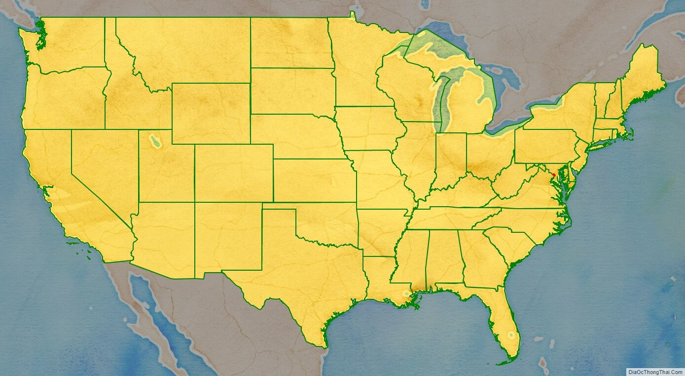
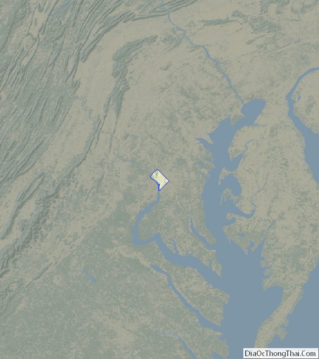
District of Columbia location map. Where is Washington DC?
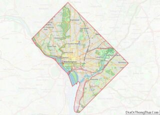
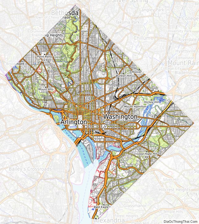
District of Columbia Road Map
District of Columbia Street Map
History
Various tribes of the Algonquian-speaking Piscataway people, also known as the Conoy, inhabited the lands around the Potomac River when Europeans arrived and colonized the region in the early 17th century. One group known as the Nacotchtank, also called the Nacostines by Catholic missionaries, maintained settlements around the Anacostia River in present-day Washington, D.C. Conflicts with European colonists and neighboring tribes forced the Piscataway people to relocate, some of whom established a new settlement in 1699 near Point of Rocks, Maryland.
Foundation
Prior to the establishment of Washington, D.C., as the nation’s capital in 1800, the Second Continental Congress was based in Philadelphia on five separate occasions (May 1775 – July 1776, December 1776 – February 1777, March 1777 – September 1777, July 1778, July 1778 – March 1781, and March 1781 – June 1783). The congressional base was briefly in five other locations: York, Pennsylvania (September 1777), Princeton, New Jersey (1783), Annapolis, Maryland (November 1783 to August 1784), Trenton, New Jersey (November to December 1784), and New York City (January 1785 to March 1789).
On October 6, 1783, after the capital was forced by the Pennsylvania Mutiny of 1783 to relocate to Princeton, New Jersey, Congress resolved to consider a new location for it. The following day, Elbridge Gerry of Massachusetts moved “that buildings for the use of Congress be erected on the banks of the Delaware near Trenton, or of the Potomac, near Georgetown, provided a suitable district can be procured on one of the rivers as aforesaid, for a federal town”.
In his Federalist No. 43, published January 23, 1788, James Madison argued that the new federal government would need authority over a national capital to provide for its own maintenance and safety. The Pennsylvania Mutiny of 1783 emphasized the need for the national government not to rely on any state for its own security.
Article One, Section Eight of the U.S. Constitution permits the establishment of a “District (not exceeding ten miles square) as may, by cession of particular states, and the acceptance of Congress, become the seat of the government of the United States”. However, the constitution does not specify a location for the capital. In the Compromise of 1790, Madison, Alexander Hamilton, and Thomas Jefferson agreed that the federal government would pay each state’s remaining Revolutionary War debts in exchange for establishing the new national capital in the Southern United States.
On July 9, 1790, Congress passed the Residence Act, which approved the creation of a national capital on the Potomac River. The exact location was to be selected by President George Washington, who signed the bill into law on July 16. Formed from land donated by Maryland and Virginia, the initial shape of the federal district was a square measuring 10 miles (16 km) on each side and totaling 100 square miles (259 km).
Two preexisting settlements were included in the territory: the port of Georgetown, Maryland, founded in 1751, and the port city of Alexandria, Virginia, founded in 1749. In 1791–92, a team led by Andrew Ellicott, including Ellicott’s brothers Joseph and Benjamin and African-American astronomer Benjamin Banneker, surveyed the borders of the federal district and placed boundary stones at every mile point; many of these stones are still standing.
A new federal city was then constructed on the north bank of the Potomac, to the east of Georgetown. On September 9, 1791, the three commissioners overseeing the capital’s construction named the city in honor of President Washington. The same day, the federal district was named Columbia, a feminine form of Columbus, which was a poetic name for the United States commonly used at that time. Congress held its first session there on November 17, 1800.
Congress passed the District of Columbia Organic Act of 1801, which officially organized the district and placed the entire territory under the exclusive control of the federal government. The area within the district was organized into two counties, the County of Washington to the east and north of the Potomac and the County of Alexandria to the west and south. After the Act’s passage, citizens in the district were no longer considered residents of Maryland or Virginia, which ended their representation in Congress.
Burning during War of 1812
On August 24–25, 1814, during the War of 1812, British forces invaded and raided Washington, D.C., in what is known as the Burning of Washington. In the attack, the U.S. Capitol, Department of the Treasury, and White House were burned and gutted. Most government buildings were repaired quickly; however, the Capitol was largely under construction at the time and was not completed in its current form until 1868.
Retrocession and the Civil War
In the 1830s, the district’s southern territory of Alexandria declined economically due in part to neglect of it by Congress. Alexandria was a major market in the domestic slave trade and pro-slavery residents feared that abolitionists in Congress would end slavery in the district, further depressing the local economy. Alexandria’s citizens petitioned Virginia to take back the land it had donated to form the district through a process known as retrocession.
The Virginia General Assembly voted in February 1846, to accept the return of Alexandria. On July 9, 1846, Congress went further, agreeing to return all territory that Virginia had ceded to the district during its formation. This left the district’s area consisting only of the portion originally donated by Maryland. Confirming the fears of pro-slavery Alexandrians, the Compromise of 1850 outlawed the slave trade in the district, although not slavery itself.
The outbreak of the American Civil War in 1861 led to the expansion of the federal government and notable growth in the district’s population, including a large influx of freed slaves. President Abraham Lincoln signed the Compensated Emancipation Act in 1862, which ended slavery in the district, freeing about 3,100 slaves in the district nine months prior to the Emancipation Proclamation. In 1868, Congress granted the district’s African American male residents the right to vote in municipal elections.
Growth and redevelopment
By 1870, the district’s population had grown 75% from the previous census to nearly 132,000 residents. Despite the city’s growth, however, Washington still had dirt roads and the city lacked basic sanitation. Some members of Congress suggested moving the capital farther west, but President Ulysses S. Grant refused to consider the proposal.
Congress passed the Organic Act of 1871, which repealed the individual charters of the cities of Washington and Georgetown, abolished Washington County, and created a new territorial government for the whole District of Columbia.
After the reorganization, in 1873, President Grant appointed Alexander Robey Shepherd as Governor of the District of Columbia. Shepherd authorized large-scale projects that greatly modernized the city but ultimately bankrupted the district government. In 1874, Congress replaced the territorial government with an appointed three-member board of commissioners.
In 1888, the city’s first motorized streetcars began service. Their introduction generated growth in areas of the district beyond the City of Washington’s original boundaries, leading to an expansion of the district over the next few decades. Georgetown’s street grid and other administrative details were formally merged to those of the City of Washington in 1895. However, the city had poor housing conditions and strained public works, leading it to become the first city in the nation to undergo urban renewal projects as part of the City Beautiful movement in the early 20th century.
Increased federal spending as a result of the New Deal in the 1930s led to the construction of new government buildings, memorials, and museums in the district, though the chairman of the House Subcommittee on District Appropriations Ross A. Collins from Mississippi justified cuts to funds for welfare and education for local residents, saying that “my constituents wouldn’t stand for spending money on niggers.”
World War II led to an expansion of federal employees in the city; by 1950, the district’s population reached its peak of 802,178 residents.
Civil rights and home rule era
The Twenty-third Amendment to the United States Constitution was ratified in 1961, granting the district three votes in the Electoral College for the election of president and vice president, but still not affording the city’s residents representation in Congress.
After the assassination of civil rights leader Martin Luther King Jr. on April 4, 1968, riots broke out in the district, primarily in the U Street, 14th Street, 7th Street, and H Street corridors, which were predominantly black residential and commercial areas. The riots raged for three days until more than 13,600 federal troops and Washington, D.C. Army National Guardsmen stopped the violence. Many stores and other buildings were burned, and rebuilding from the riots was not completed until the late 1990s.
In 1973, Congress enacted the District of Columbia Home Rule Act providing for an elected mayor and 13-member council for the district. In 1975, Walter Washington became the district’s first elected and first black mayor.
Since the 1980s, the D.C. statehood movement has grown in prominence. In 2016, a referendum on D.C. statehood resulted in a 85% support among District voters for Washington to become the 51st state of the United States. In March 2017, D.C.’s congressional delegate Eleanor Holmes Norton introduced a bill for D.C. statehood. Reintroduced in 2019 and 2021 as the Washington, D.C., Admission Act, the U.S. House of Representatives passed it in April 2021. After not progressing in the Senate, the statehood bill was introduced again in January 2023.
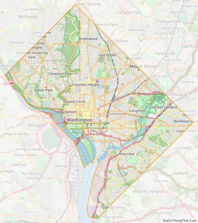
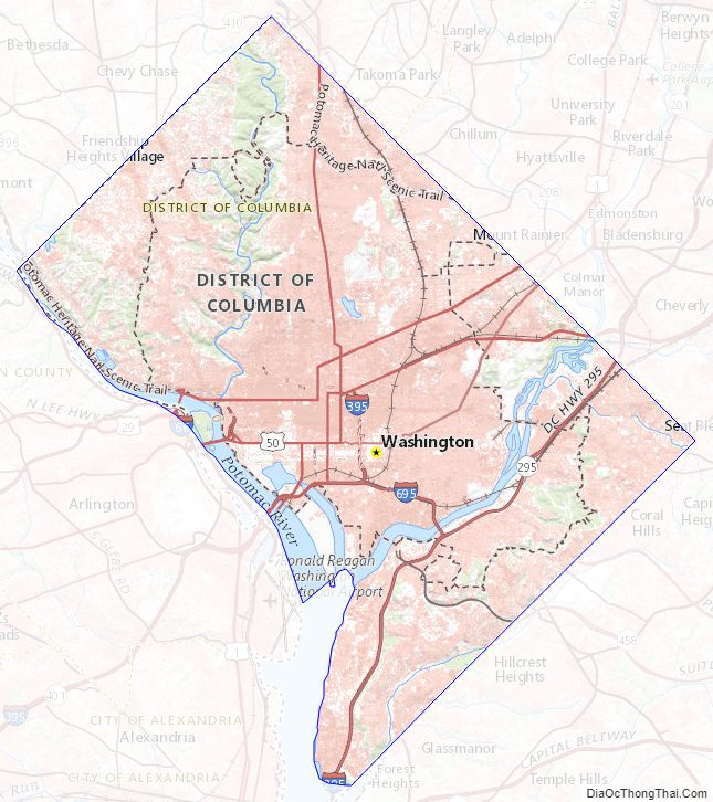
District of Columbia Political Map

Geography
Washington, D.C., is located in the mid-Atlantic region of the U.S. East Coast. The city has a total area of 68.34 square miles (177 km), of which 61.05 square miles (158.1 km) is land and 7.29 square miles (18.9 km) (10.67%) is water. The district is bordered by Montgomery County, Maryland, to the northwest; Prince George’s County, Maryland, to the east; Arlington County, Virginia, to the west; and Alexandria, Virginia, to the south. Washington, D.C., is 38 miles (61 km) from Baltimore, 124 miles (200 km) from Philadelphia, 227 miles (365 km) from New York City, 242 miles (389 km) from Pittsburgh, 384 miles (618 km) from Charlotte, and 439 miles (707 km) from Boston.
The south bank of the Potomac River forms the district’s border with Virginia and has two major tributaries, the Anacostia River and Rock Creek. Tiber Creek, a natural watercourse that once passed through the National Mall, was fully enclosed underground during the 1870s. The creek also formed a portion of the now-filled Washington City Canal, which allowed passage through the city to the Anacostia River from 1815 until the 1850s. The Chesapeake and Ohio Canal starts in Georgetown and was used during the 19th century to bypass the Little Falls of the Potomac River, located at the northwest edge of the city at the Atlantic Seaboard fall line.
The highest natural elevation in the district is 409 feet (125 m) above sea level at Fort Reno Park in upper northwest Washington, D.C.. The lowest point is sea level at the Potomac River. The geographic center of Washington is near the intersection of 4th and L Streets NW.
The district has 7,464 acres (30.21 km) of parkland, about 19% of the city’s total area and the second-highest percentage among high-density U.S. cities after Philadelphia. The city’s sizable parkland was a factor in the city being ranked as third in the nation for park access and quality in the 2018 ParkScore ranking of the park systems of the nation’s 100 most populous cities, according to Trust for Public Land, a non-profit organization.
The National Park Service manages most of the 9,122 acres (36.92 km) of city land owned by the U.S. government. Rock Creek Park is a 1,754-acre (7.10 km) urban forest in Northwest Washington, which extends 9.3 miles (15.0 km) through a stream valley that bisects the city. Established in 1890, it is the country’s fourth-oldest national park and is home to a variety of plant and animal species, including raccoon, deer, owls, and coyotes. Other National Park Service properties include the Chesapeake and Ohio Canal National Historical Park, the National Mall and Memorial Parks, Theodore Roosevelt Island, Columbia Island, Fort Dupont Park, Meridian Hill Park, Kenilworth Park and Aquatic Gardens, and Anacostia Park. The District of Columbia Department of Parks and Recreation maintains the city’s 900 acres (3.6 km) of athletic fields and playgrounds, 40 swimming pools, and 68 recreation centers. The U.S. Department of Agriculture operates the 446-acre (1.80 km) United States National Arboretum in Northeast Washington, D.C..
Climate
Washington, D.C., is in the humid subtropical climate zone (Köppen: Cfa). The Trewartha classification is defined as an oceanic climate (Do). Winters are cool to cold with light snow more common but heavy snow not uncommon, and summers are hot and humid. The district is in plant hardiness zone 8a near downtown, and zone 7b elsewhere in the city, indicating a humid subtropical climate.
Spring and fall are mild to warm while winter is cool to cold with annual snowfall averaging 15.5 inches (39 cm).
Summers are hot and humid with a July daily average of 79.8 °F (26.6 °C) and average daily relative humidity around 66%, which can cause moderate personal discomfort. Heat indices regularly approach 100 °F (38 °C) at the height of summer. The combination of heat and humidity in the summer brings very frequent thunderstorms, some of which occasionally produce tornadoes in the area.
Blizzards affect Washington once every four to six years on average. The most violent storms, known as nor’easters, often impact large regions of the East Coast. From January 27 to 28, 1922, the city officially received 28 inches (71 cm) of snowfall, the largest snowstorm since official measurements began in 1885. According to notes kept at the time, the city received between 30 and 36 inches (76 and 91 cm) from a snowstorm in January 1772.
Hurricanes or their remnants occasionally impact the area in late summer and early fall. However, they usually are weak by the time they reach Washington, D.C., partly due to the city’s inland location. Flooding of the Potomac River, however, caused by a combination of high tide, storm surge, and runoff, has been known to cause extensive property damage in the Georgetown neighborhood of the city. Precipitation occurs throughout the year.
The highest recorded temperature was 106 °F (41 °C) on August 6, 1918, and on July 20, 1930. The lowest recorded temperature was −15 °F (−26 °C) on February 11, 1899, right before the Great Blizzard of 1899. During a typical year, the city averages about 37 days at or above 90 °F (32 °C) and 64 nights at or below the freezing mark (32 °F or 0 °C). On average, the first day with a minimum at or below freezing is November 18 and the last day is March 27.
See or edit raw graph data.
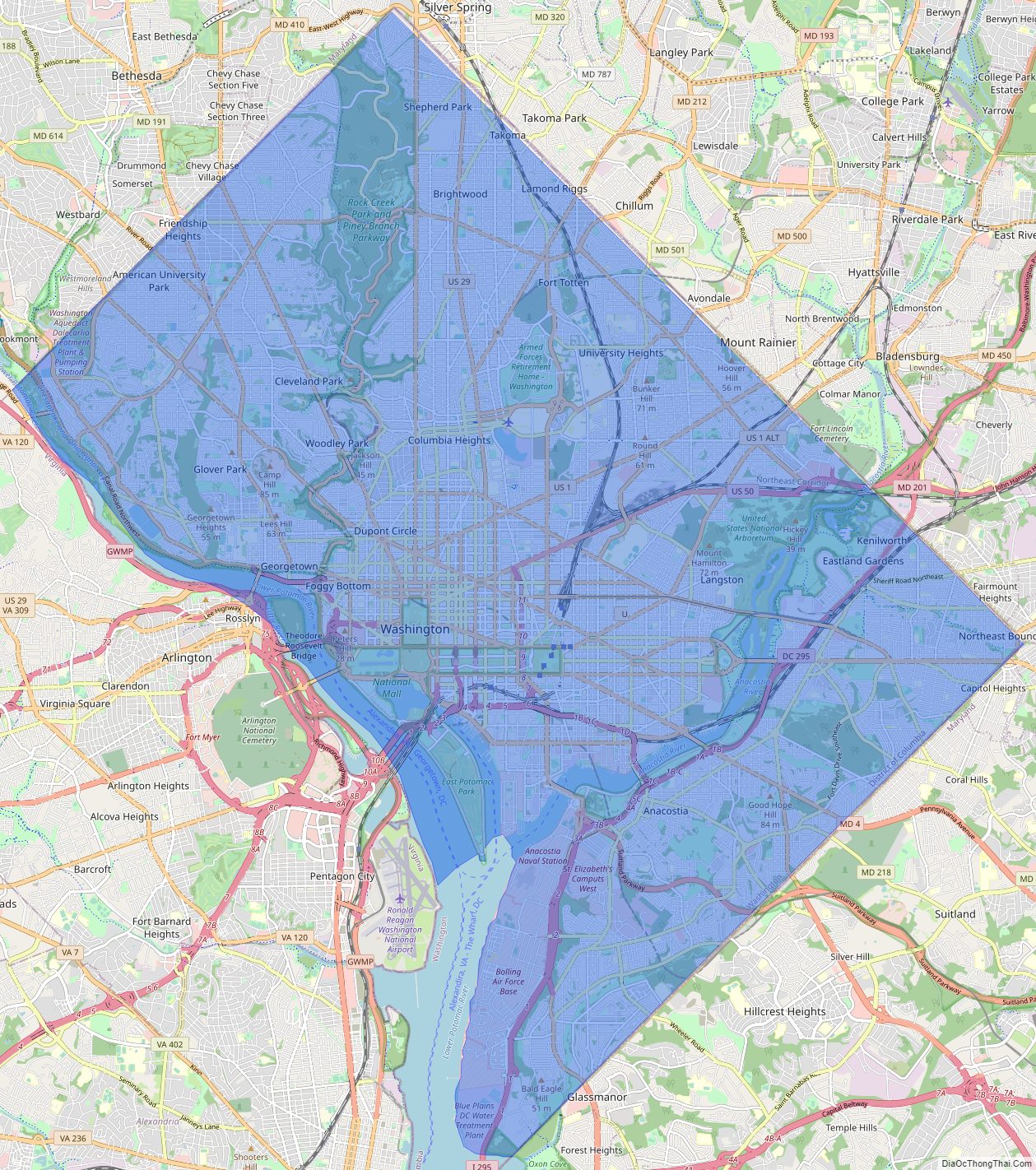
District of Columbia Physical Map
District of Columbia Topographic Map
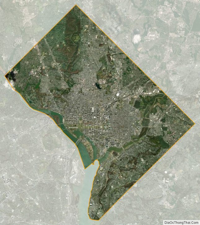
District of Columbia Satellite Map
Others printable maps
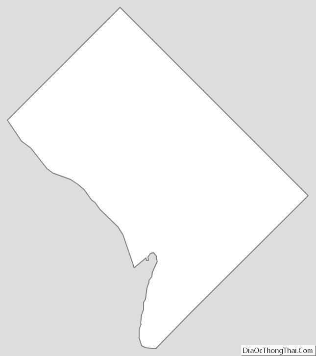
District of Columbia Outline Map
Blank District of Columbia County Map

See also
Map of District of Columbia Federal District and its subdivision: Map of other states:- Alabama
- Alaska
- Arizona
- Arkansas
- California
- Colorado
- Connecticut
- Delaware
- District of Columbia
- Florida
- Georgia
- Hawaii
- Idaho
- Illinois
- Indiana
- Iowa
- Kansas
- Kentucky
- Louisiana
- Maine
- Maryland
- Massachusetts
- Michigan
- Minnesota
- Mississippi
- Missouri
- Montana
- Nebraska
- Nevada
- New Hampshire
- New Jersey
- New Mexico
- New York
- North Carolina
- North Dakota
- Ohio
- Oklahoma
- Oregon
- Pennsylvania
- Rhode Island
- South Carolina
- South Dakota
- Tennessee
- Texas
- Utah
- Vermont
- Virginia
- Washington
- West Virginia
- Wisconsin
- Wyoming