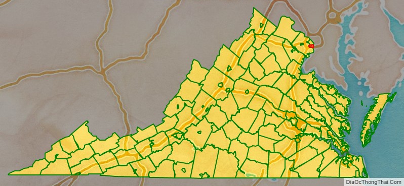
Alexandria is an independent city in the northern region of the Commonwealth of Virginia, United States. It lies on the western bank of the Potomac River approximately 7 miles (11 km) south of downtown Washington, D.C. Alexandria is the third-largest “principal city” of the Washington metropolitan area which is part of the larger Washington-Baltimore combined statistical area.
In 2020, the population was 159,467, making it the 6th most populous city in Virginia and the 169th most populous city in the nation. The city’s estimated population has grown by 1% annually since 2010 on average.
Like the rest of Northern Virginia and Central Maryland, modern Alexandria has been influenced by its proximity to the U.S. capital. It is largely populated by professionals working in the federal civil service, in the U.S. military, or for one of the many private companies which contract to provide services to the federal government. One of Alexandria’s largest employers is the U.S. Department of Defense. Another is the Institute for Defense Analyses. In 2005, the United States Patent and Trademark Office moved to Alexandria, and in 2017, so did the headquarters of the National Science Foundation.
The historic center of Alexandria is known as Old Town Alexandria (or simply “Old Town”). With its concentration of boutiques, restaurants, antique shops and theaters, it is a major draw for all who live in Alexandria as well as for visitors. Like Old Town, many Alexandria neighborhoods are compact and walkable. It is the 6th largest and highest-income independent city in Virginia. A large portion of adjacent Fairfax County, mostly south but also west of the city, has Alexandria mailing addresses. However, this area is under the jurisdiction of Fairfax County’s government and separate from the independent city. The city is therefore sometimes referred to as the “City of Alexandria” to avoid confusion (see the “Neighborhoods” paragraph below). Additionally, neighboring Arlington County was formerly named “Alexandria County” before it was renamed by the Virginia General Assembly in 1920 to reduce confusion with the city.
| Name: | Alexandria City |
|---|---|
| FIPS code: | 51-510 |
| State: | Virginia |
| Founded: | 1749 |
| Total Area: | 15.35 sq mi (39.75 km²) |
| Land Area: | 14.93 sq mi (38.68 km²) |
| Total Population: | 159,467 |
| Population Density: | 10,680.97/sq mi (4,122.72/km²) |
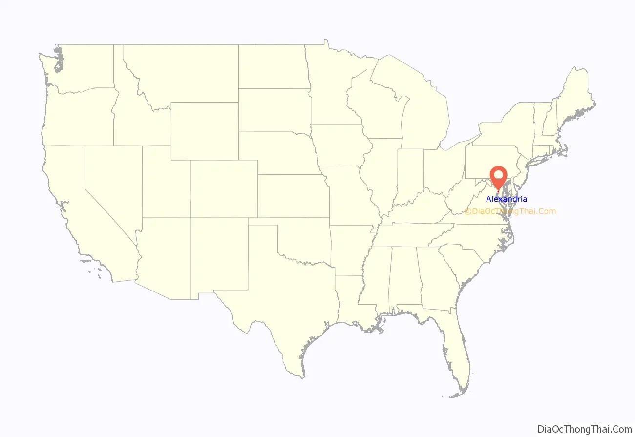
Alexandria City location map. Where is Alexandria City?
History
Early history
According to archaeologists’ estimates, a succession of indigenous peoples began to occupy the Chesapeake and Tidewater region about 3,000 to 10,000 years ago. Various Algonquian-speaking peoples inhabited the lands in the Potomac River drainage area since at least the early 14th century.
In the summer of 1608, English settler John Smith explored the Potomac River and came into contact with the Patawomeck (loosely affiliated with the Powhatan) and Doeg tribes who lived on the Virginia side, as well as on Theodore Roosevelt Island, and the Piscataway (also known as the Conoy), who resided on the Maryland side. On this visit, Smith recorded the presence of a settlement called Assaomeck near the south bank of what is now Hunting Creek.
Colonial era
On October 21, 1669, a patent granted 6,000 acres (24 km) to Robert Howsing for transporting 120 people to the Colony of Virginia. That tract would later become the City of Alexandria. Virginia’s comprehensive Tobacco Inspection Law of 1730 mandated that all tobacco grown in the colony must be brought to locally designated public warehouses for inspection before sale. One of the sites designated for a warehouse on the upper Potomac River was at the mouth of Hunting Creek. However, the ground proved to be unsuitable, and the warehouse was built half a mile up-river, where the water was deep near the shore.
Following the 1745 settlement of the Virginia’s 10-year dispute with Lord Fairfax over the western boundary of the Northern Neck Proprietary, when the Privy Council in London found in favor of Lord Fairfax’s expanded claim, some of the Fairfax County gentry formed the Ohio Company of Virginia. They intended to conduct trade into the interior of America, and they required a trading center near the head of navigation on the Potomac. The best location was Hunting Creek tobacco warehouse, since the deep water could easily accommodate sailing ships. Many local tobacco planters, however, wanted a new town further up Hunting Creek, away from nonproductive fields along the river.
Around 1746, Captain Philip Alexander II (1704–1753) moved to what is south of present Duke Street in Alexandria. His estate, which consisted of 500 acres (2.0 km), was bounded by Hunting Creek, Hooff’s Run, the Potomac River, and approximately the line which would become Cameron Street. At the opening of Virginia’s 1748–49 legislative session, there was a petition submitted in the House of Burgesses on November 1, 1748, that the “inhabitants of Fairfax (Co.) praying that a town may be established at Hunting Creek Warehouse on Potowmack River,” as Hugh West was the owner of the warehouse. The petition was introduced by Lawrence Washington, the representative for Fairfax County and, more importantly, the son-in-law of William Fairfax and a founding member of the Ohio Company. To support the company’s push for a town on the river, Lawrence’s younger brother George Washington, an aspiring surveyor, made a sketch of the shoreline touting the advantages of the tobacco warehouse site.
Since the river site was amidst his estate, Philip opposed the idea and strongly favored a site at the head of Hunting Creek (also known as Great Hunting Creek). It has been said that in order to avoid a predicament the petitioners offered to name the new town Alexandria, in honor of Philip’s family. As a result, Philip and his cousin Captain John Alexander (1711–1763) gave land to assist in the development of Alexandria, and are thus listed as the founders. This John was the son of Robert Alexander II (1688–1735). On May 2, 1749, the House of Burgesses approved the river location and ordered “Mr. Washington do go up with a Message to the Council and acquaint them that this House have agreed to the Amendments titled An Act for erecting a Town at Hunting Creek Warehouse, in the County of Fairfax.” A “Public Vendue” (auction) was advertised for July, and the county surveyor laid out street lanes and town lots. The auction was conducted on July 13–14, 1749.
Almost immediately upon establishment, the town founders called the new town “Belhaven”, believed to be in honor of a Scottish patriot, John Hamilton, 2nd Lord Belhaven and Stenton, the Northern Neck tobacco trade being then dominated by Scots. The name Belhaven was used in official lotteries to raise money for a Church and Market House, but it was never approved by the legislature and fell out of favor in the mid-1750s. The town of Alexandria did not become incorporated until 1779.
In 1755, General Edward Braddock organized his fatal expedition against Fort Duquesne at Carlyle House in Alexandria. In April 1755, the governors of Virginia, and the provinces of Maryland, Pennsylvania, Massachusetts, and New York met to determine upon concerted action against the French in America.
In March 1785, commissioners from Virginia and Maryland met in Alexandria to discuss the commercial relations of the two states, finishing their business at Mount Vernon. The Mount Vernon Conference concluded on March 28 with an agreement for freedom of trade and freedom of navigation of the Potomac River. The Maryland legislature, in ratifying this agreement on November 22, proposed a conference among representatives from all the states to consider the adoption of definite commercial regulations. This led to the calling of the Annapolis Convention of 1786, which in turn led to the calling of the Federal Convention of 1787.
In 1791, Alexandria was included in the area chosen by George Washington to become the District of Columbia.
Early 19th century
In 1814, during the War of 1812, a British fleet launched a successful Raid on Alexandria, which surrendered without a fight. As agreed in the terms of surrender the British looted stores and warehouses of mainly flour, tobacco, cotton, wine, and sugar. In 1823 William Holland Wilmer, Francis Scott Key, and others founded the Virginia Theological Seminary. From 1828 to 1836, Alexandria was home to the Franklin & Armfield Slave Market, one of the largest slave trading companies in the country. By the 1830s, they were sending more than 1,000 slaves annually from Alexandria to their Natchez, Mississippi, New Orleans, and later Texas markets to help meet the demand for slaves in Mississippi and nearby states. Later owned by Price, Birch & Co., the slave pen became a jail under Union occupation.
A portion of the City of Alexandria—most of the area now known as Old Town as well as the areas of the city northeast of what is now King Street—and all of today’s Arlington County share the distinction of having been the portion of Virginia ceded to the U.S. Government in 1791 to help form the new District of Columbia. Over time, a movement grew to separate what was called “Alexandria County” from the District of Columbia. As competition grew with the port of Georgetown and the Chesapeake and Ohio Canal fostered development on the north side of the Potomac River, Alexandria’s economy stagnated; at the same time, residents had lost any representation in Congress and the right to vote, and were disappointed with the negligible economic benefit (on the Alexandria side) of being part of the national capital. Alexandria still had an important port and market in the slave trade, and as talk increased of abolishing slavery in the national capital, there was concern that Alexandria’s economy would suffer greatly if this step were taken. After a referendum, voters petitioned Congress and Virginia to return the portion of the District of Columbia south of the Potomac River (Alexandria County) to Virginia. On July 9, 1846, Congress retroceded Alexandria County to Virginia. The City of Alexandria was re-chartered in 1852 and became independent of Alexandria County in 1870. The remaining portion of Alexandria County changed its name to Arlington County in 1920.
Late 19th century
The first fatalities of the North and South in the American Civil War occurred in Alexandria. Within a month of the Battle of Fort Sumter, Union troops occupied Alexandria, landing troops at the base of King Street on the Potomac River on May 24, 1861. A few blocks up King Street from their landing site, the commander of the New York Fire Zouaves, Colonel Elmer E. Ellsworth, sortied with a small detachment to remove a large Confederate flag displayed on the roof of the Marshall House Inn that had been visible from the White House. While descending from the roof, Ellsworth was shot dead by James W. Jackson, the hotel’s proprietor. One of Ellsworth’s soldiers immediately killed Jackson. Ellsworth was publicized as a Union martyr, and the incident generated great excitement in the North, with many children being named for him. Jackson’s death defending his home caused a similar sensation in the South.
Alexandria remained under military occupation until the end of the war. Fort Ward, one of a ring of forts built by the Union army for the defense of Washington, D.C., is located inside the boundaries of present-day Alexandria. There were five military prisons in the city, the largest being the Washington Street Military Prison. After the creation by Washington of the state of West Virginia in 1863 and until the close of the war, Alexandria was the seat of the so-called Restored Government of Virginia, also known as the “Alexandria Government”. During the Union occupation, a recurring contention between the Alexandria citizenry and the military occupiers was the Union army’s periodic insistence that church services include prayers for the President of the United States. Failure to do so resulted in incidents including the arrest of ministers in their church.
In 1861 and 1862, escaped African-American slaves poured into Alexandria. Safely behind Union lines, the cities of Alexandria and Washington offered comparative freedom and employment. Alexandria became a major supply depot and transport and hospital center for the Union army. Until the Emancipation Proclamation of January 1, 1863, escaped slaves legally remained the property of their owners. Therefore, they were labeled contrabands to avoid returning them to their masters. Contrabands worked for the Union army in various support roles.
After all slaves in the seceding states were liberated, even more African Americans came to Alexandria. By the fall of 1863, the population of Alexandria had exploded to 18,000—an increase of 10,000 people in 16 months.
As of ratification of the Fifteenth Amendment, Alexandria County’s black population was more than 8,700, or about half the total number of residents in the county. This newly enfranchised constituency provided the support necessary to elect the first black Alexandrians to the City Council and the Virginia Legislature.
20th century
At the turn of the 20th century the most common production in the city was glass, fertilizer, beer, and leather. The glass often went into beer bottles. Much of the Virginia Glass Company effort went to supply the demands of the Robert Portner Brewing Company, until fire destroyed the St. Asaph Street plant on February 18, 1905. The Old Dominion Glass Company also had a glass works fall to fire, then built a new one. The Belle Pre Bottle Company held a monopoly on a milk bottle that they patented, yet that organization only lasted 10 years. Most businesses were smaller where the business occupied the first floor of a building and the owner and family lived above. Prohibition closed Portner Brewing in 1916.
President Woodrow Wilson visited the Virginia Shipbuilding Corporation on May 30, 1918, to drive the first rivet into the keel of the SS Gunston Hall. In 1930, Alexandria annexed the town adjacent to Potomac Yard incorporated in 1908 named Potomac. In 1938 the Mt. Vernon Drive-In cinema opened. In 1939, the segregated public library experienced a sit-in organized by Samuel Wilbert Tucker. In 1940, both the Robert Robinson Library, which is now the Alexandria Black History Museum, and the Vernon Theatre opened Jim Morrison of The Doors, as well as Cass Elliot and John Phillips of The Mamas & The Papas attended the George Washington High School in the 1950s.
In 1955, then-Congressman and future President Gerald R. Ford and his family moved to Alexandria from Georgetown. The Fords remained in their Alexandria home during Ford’s tenure as Vice President (1973-1974), as the Vice President did not yet have an official residence. Following the resignation of Richard Nixon, Ford spent his first 10 days as President in the house before moving to the White House.
In March 1959, Lieutenant Colonel William Henry Whalen, the “highest-ranking American ever recruited as a mole by the Russian Intelligence Service”, provided Colonel Sergei A. Edemski three classified Army manuals in exchange for $3,500 at a shopping center parking lot within the city. Agents of the Federal Bureau of Investigation later arrested Whalen on July 12, 1966, at his home in the city. In 1961 the original Woodrow Wilson Bridge opened.
In 1965, the city integrated schools. In 1971, the city consolidated all high school students into T. C. Williams High School. The same year that head coach Herman Boone joined the school and lead the football team to a 13–0 season, a state championship, and a national championship runner-up; the basis for the 2000 film Remember the Titans where Boone was portrayed by Denzel Washington. In 1972, Clifford T. Cline purchased the 1890 Victorian house at 219 King Street and converted it into the Creole serving Two-Nineteen Restaurant. In 1973, Nora Lamborne and Beverly Beidler became the first women elected to the city council. In 1974, the Torpedo Factory Art Center opened. In 1983, the King Street–Old Town station, Braddock Road station, and Eisenhower Avenue station opened as the Washington Metro system expanded. In 1991, the Van Dorn Street station opened and Patricia Ticer became the first woman elected mayor.
History of libraries
John Wise, a local Alexandria businessman and hotel keeper, hosted a meeting in his home in 1789 to discuss the creation of a Society for the Promotion of Useful Knowledge. Members include Rev. James Muir, physician Elisha Cullen Dick, and George Washington’s personal attorney Charles Lee. The Society did not last for long. However, on July 24, 1794, the founders of the Society once again met at Wise’s home to establish a subscription library. During the first year, one hundred nineteen men joined the circulating library which was to be called the Library Company of Alexandria. Members agreed to pay an initiation fee and annual dues. The company was chartered as a corporation in 1798 in an act passed by the General Assembly of Virginia.
Druggist Edward Stabler was elected the first librarian and the library’s first location is believed to have been housed in his apothecary shop. James Kennedy was elected the second librarian, and the library moved to his residence and place of business. Kennedy sold books from his personal collection to the Library Company. Those books and other bought from two local merchants formed the foundation of the subscription library. The first catalog of the library’s collection was published in 1797. The collection grew over time, bolstered in part by the fact that some members paid their dues in books. Most members were initially men, although records exist showing some women were members as early as 1798. One noted female member in 1817 was Mary L.F. Custis, wife of George Washington Parke Custis.
The catalog published in 1801 indicated a collection of 452 books, mostly on history and travel. By 1815, there were 1,022 entries in the catalog, and the collection had added more biographies, fiction, and magazines. The library was housed in several locations over the ensuing years, including the New Market House next to the City Hall, the Lyceum Company building, and Peabody Hall, which was owned by the Alexandria School Board. Raising funds for the library was a continuing challenge. In 1853, a lecture series was created to raise money. Speakers included Professor Joseph Henry of the Smithsonian, Colonel Francis H. Smith of the Virginia Military Institute, and humorist George W. Bagby.
The Civil War took its toll on the library collection. Members were able to remove some of the collection prior to the library’s occupation by Union troops. The library was used as a hospital and much of the library’s collection was lost during this time. After the war, the building was sold to a private owner who planned to turn the building into a private residence and asked the library to remove what was left of the collection. Funds continued to be hard to come by and in 1879, the Library Company closed. The remainder of its collection was stored in Peabody Hall.
In 1897, a group of women in Alexandria formed the Alexandria Library Association. The leaders of the group were Virginia Corse, Mrs. William B. Smoot, and Virginia Burke. They petitioned the school board to open a subscription library in Peabody Hall, using the old books stored there. Permission was given and doors to the new subscription library opened on December 1, 1897. In 1902, the library moved to the first floor of a house in the 1300 block of Prince Street while negotiations were underway for a permanent move to the Confederate Hall, located at 806 Prince Street. In May 1903, the library moved to the Confederate Hall, now known as the Robert E. Lee Camp Hall Museum, where it stayed for 34 years.
In 1936, Dr. and Mrs. Robert South Barrett presented a proposal to the Library Association. They agreed to donate a building in memory of Dr. Barrett’s mother, Kate Waller Barrett, if the city would commit to running it as a public library. The city agreed and the Society of Friends offered a 99-year lease on an old Quaker graveyard located on Queen Street. The old library was closed on March 1 for the books to be packed and moved to the new library, which opened to the public in August 1937. The Alexandria Library Association became the Alexandria Library Society.
In 1939, the Barrett library was the scene of possibly the nation’s first sit-in demonstrations, as Samuel Tucker, a young law school graduate from the neighborhood, and several other African-American residents insisted on access to the racially segregated library where they had been banned. Tucker later became a prominent attorney in Richmond.
In 1947, the Library Society was reconstituted and took the earlier historic name Alexandria Library Company. A lecture series was also revived. Speakers included Thomas Jefferson biographer Dumas Malone. Some of the books belonging in the original collection of the Alexandria Library Company can now be found in the Local History/Special Collections Room at the Queen Street library that still carries Mrs. Barrett’s name.
In 1948, Ellen Coolidge Burke became director. Burke brought bookmobile services to Alexandria, one of the first services in Virginia. She oversaw the growth of the library system by the addition of two new branch libraries. In April 1968 the Ellen Coolidge Burke Branch at 4701 Seminary Road was opened, and in December 1969 the James M. Duncan branch at 2501 Commonwealth Avenue. Burke retired in 1969.
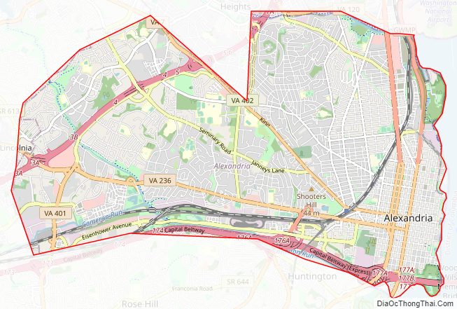
Alexandria City Road Map
Geography
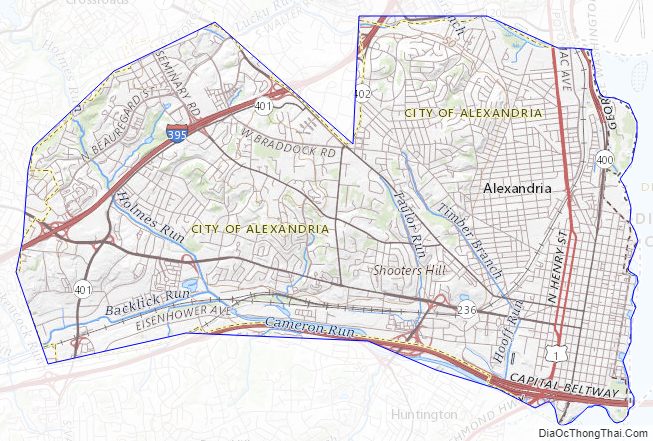
According to the U.S. Census Bureau, the city has a total area of 15.5 square miles (40.1 km), of which 15.0 square miles (38.9 km) is land and 0.42 square miles (1.1 km), or 2.85%, is water. Alexandria is bounded on the east by the Potomac River, on the north and northwest by Arlington County, and on the south by Fairfax County. The western portions of the city were annexed from those two entities beginning in the 1930s.
The addressing system in Alexandria is not uniform and reflects the consolidation of several originally separate communities into a single city. In Old Town Alexandria, building numbers are assigned north and south from King Street and west (only) from the Potomac River. In the areas formerly in the town of Potomac, such as Del Ray and St. Elmo, building numbers are assigned east and west from Commonwealth Avenue and north (only) from King Street. In the western parts of the city, building numbers are assigned north and south from Duke Street.
The ZIP Code prefix 223 uniquely identifies the Alexandria postal area. However, the Alexandria postal area extends into Fairfax County and includes addresses outside of the city. Delivery areas have ZIP codes 22301, 22302, 22303, 22304, 22305, 22306, 22307, 22308, 22309, 22310, 22311, 22312, 22314, and 22315, with other ZIP codes in use for post office boxes and large mailers (22313, 22331, 22332, 22333).
Part of the George Washington Memorial Parkway is the one national protected area within the borders of Alexandria.
Adjacent jurisdictions
- Arlington County, Virginia – north
- Charles County, Maryland – southeast
- District of Columbia – northeast
- Fairfax County, Virginia – west and south
- Prince George’s County, Maryland – east
Neighborhoods
Neighborhoods in the City of Alexandria include Old Town, Parker-Gray, The Berg, Arlandria, Rosemont, Del Ray, Beverley Hills, Braddock Heights, Eisenhower Valley, Seminary Valley, Temple Park, West End, and Potomac Yard.
Many areas outside the city have an Alexandria mailing address yet are a part of Fairfax County including: Hollin Hills, Franconia, Groveton, Hybla Valley, Huntington, Lincolnia, Belle Haven, Mount Vernon, Fort Hunt, Engleside, Burgundy Village, Waynewood, Wilton Woods, Rose Hill, Virginia Hills, Hayfield, and Kingstowne. Some refer to these areas as Lower Alexandria, South Alexandria, or Alexandria, Fairfax County.
Climate
The climate in this area is characterized by hot, humid summers and generally mild to cool winters. According to the Köppen climate classification system, Alexandria has a humid subtropical climate, abbreviated “Cfa” on climate maps.
Alexandria City Topographic Map
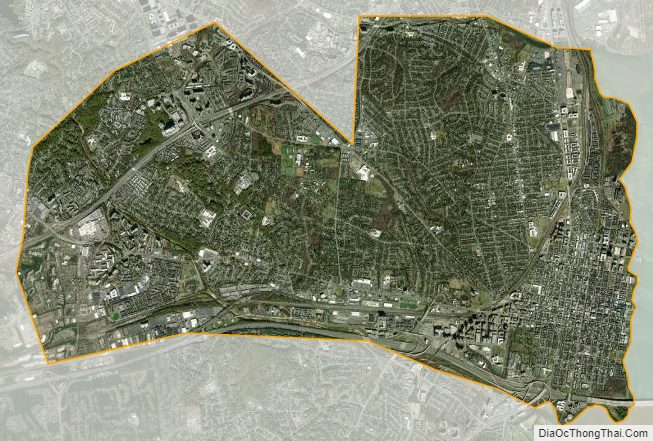
Alexandria City Satellite Map
Alexandria City Outline Map