Map of Leesburg town

Map of Leesburg town, Alabama

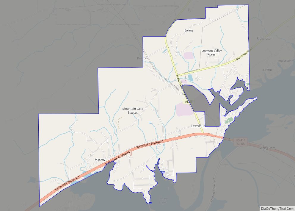
Leesburg is a town in Cherokee County, Alabama, United States. At the 2020 census, the population was 911. Leesburg town overview: Name: Leesburg town LSAD Code: 43 LSAD Description: town (suffix) State: Alabama County: Cherokee County Elevation: 610 ft (186 m) Total Area: 6.28 sq mi (16.27 km²) Land Area: 6.27 sq mi (16.24 km²) Water Area: 0.01 sq mi (0.03 km²) Total Population: 911 Population … Read more

Map of Leeds city

Map of Leeds city, Alabama

Leeds is a tri-county municipality located in Jefferson, St. Clair, and Shelby counties in the State of Alabama and is an eastern suburb of Birmingham. As of the 2020 census, the population of the city was 12,324. Leeds was founded in 1877, during the final years of the post-Civil War Reconstruction Era. It housed the … Read more

Map of Langston town

Map of Langston town, Alabama

Langston is a town in Jackson County, Alabama, United States, and is included in the Chattanooga-Cleveland-Dalton, TN-GA-AL Combined Statistical Area. As of the 2010 census, the population of the town was 270, up from 254. Langston initially incorporated in 1899. At some point after 1920, it disincorporated and did not reincorporate again until 1980 (after … Read more

Map of Lester town

Map of Lester town, Alabama

Lester is a town in Limestone County, Alabama, United States, and is included in the Huntsville-Decatur Combined Statistical Area. As of the 2010 census, the population of the town is 111, up from 107 in 2000. Lester town overview: Name: Lester town LSAD Code: 43 LSAD Description: town (suffix) State: Alabama County: Limestone County Elevation: … Read more

Map of Leroy CDP

Map of Leroy CDP, Alabama

Leroy is a census-designated place located in Washington County, Alabama, around 60 miles (97 km) north of Mobile. As of the 2010 census, its population was 911. Leroy CDP overview: Name: Leroy CDP LSAD Code: 57 LSAD Description: CDP (suffix) State: Alabama County: Washington County Elevation: 167 ft (51 m) Total Area: 11.98 sq mi (31.02 km²) Land Area: 11.91 sq mi (30.85 km²) … Read more

Map of Leighton town

Map of Leighton town, Alabama

Leighton is a town in Colbert County, Alabama, United States. It is part of the Florence – Muscle Shoals Metropolitan Statistical Area known as “The Shoals”. At the 2020 census, the population was 665. Leighton has been hit by several tornadoes in the 2000s, including a damaging EF2 on May 8, 2008, that was caught … Read more

Map of Libertyville town

Map of Libertyville town, Alabama

Libertyville is a town in Covington County, Alabama, United States. At the 2020 census, the population was 108. Libertyville town overview: Name: Libertyville town LSAD Code: 43 LSAD Description: town (suffix) State: Alabama County: Covington County Elevation: 269 ft (82 m) Total Area: 0.52 sq mi (1.36 km²) Land Area: 0.52 sq mi (1.35 km²) Water Area: 0.00 sq mi (0.01 km²) Total Population: 108 Population … Read more

Map of Lexington town

Map of Lexington town, Alabama

Lexington is a town in Lauderdale County, Alabama, United States. It is part of the Florence – Muscle Shoals Metropolitan Statistical Area known as “The Shoals”. It incorporated in 1959. As of the 2010 census, the population of the town is 735, down from 840 in 2000. The current mayor of Lexington is Sandra Killen-Burroughs. … Read more

Map of Level Plains town

Map of Level Plains town

Level Plains is a small town in Dale County, Alabama, United States. At the 2020 census, the population was 1,825. It is part of the Ozark micropolitan statistical area. Level Plains was ranked as a city from 2010 to 2020, but due to a population decline reverted to a town after the 2020 Census. Mayor … Read more

Map of Linden city

Map of Linden city, Alabama

Linden is a city in and the county seat of Marengo County, Alabama, United States. The population was 1,930 at the 2020 census, down from 2,123 at the 2010 census. Linden city overview: Name: Linden city LSAD Code: 25 LSAD Description: city (suffix) State: Alabama County: Marengo County Elevation: 161 ft (49 m) Total Area: 3.61 sq mi (9.36 km²) … Read more

Map of Lincoln city

Map of Lincoln city, Alabama

Lincoln is a city in Talladega County, Alabama, United States. It was incorporated in 1911. At the 2020 census, the population was 6,845. It was named for Major General Benjamin Lincoln, who served in the American army during the Revolutionary War. The Talladega Superspeedway, the International Motorsports Hall of Fame and the Talladega Municipal Airport … Read more

Map of Lillian CDP

Map of Lillian CDP

Lillian is an unincorporated community and census-designated place in eastern Baldwin County, Alabama, United States. Lillian is located on U.S. Route 98 on the western shore of Perdido Bay, 9.5 miles (15.3 km) east of Elberta. Its eastern edge lies on the Alabama/Florida state line. Lillian CDP overview: Name: Lillian CDP LSAD Code: 57 LSAD Description: … Read more