Map of Onycha town

Map of Onycha town

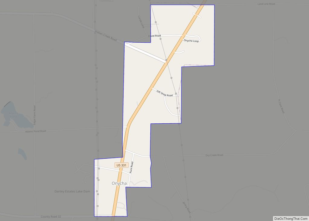
Onycha is a town in Covington County, Alabama, United States. At the 2020 census, the population was 167. Onycha town overview: Name: Onycha town LSAD Code: 43 LSAD Description: town (suffix) State: Alabama County: Covington County Elevation: 318 ft (97 m) Total Area: 0.80 sq mi (2.08 km²) Land Area: 0.79 sq mi (2.05 km²) Water Area: 0.01 sq mi (0.02 km²) Total Population: 167 Population … Read more

Map of Oneonta city

Map of Oneonta city, Alabama

Oneonta (/ˌɒniˈɒnɒ/) is a city in Blount County, Alabama, United States. At the 2020 census, the population was 6,938. The city is the county seat of Blount County. Oneonta is home to the Covered Bridge Festival. Oneonta city overview: Name: Oneonta city LSAD Code: 25 LSAD Description: city (suffix) State: Alabama County: Blount County Elevation: … Read more

Map of Ohatchee town

Map of Ohatchee town

Ohatchee (inc. 1956) is a town in Calhoun County, Alabama, United States. At the 2020 census, the population was 1,157. It is included in the Anniston–Oxford, Alabama Metropolitan Statistical Area. Ohatchee town overview: Name: Ohatchee town LSAD Code: 43 LSAD Description: town (suffix) State: Alabama County: Calhoun County Elevation: 509 ft (155 m) Total Area: 5.92 sq mi (15.34 km²) … Read more

Map of Orange Beach city

Map of Orange Beach city

Orange Beach is a resort city in Baldwin County, Alabama, United States. As of the 2020 Census, the population was 8,095. Orange Beach city overview: Name: Orange Beach city LSAD Code: 25 LSAD Description: city (suffix) State: Alabama County: Baldwin County Elevation: 0 ft (0 m) Total Area: 15.95 sq mi (41.30 km²) Land Area: 14.71 sq mi (38.11 km²) Water Area: 1.23 sq mi … Read more

Map of Opp city

Map of Opp city

Opp is a city in Covington County, Alabama, United States. At the 2020 census, the population was 6,771. Opp is named after Henry Opp, a lawyer for the Louisville and Nashville Railroad. Opp city overview: Name: Opp city LSAD Code: 25 LSAD Description: city (suffix) State: Alabama County: Covington County Elevation: 338 ft (103 m) Total Area: … Read more

Map of Opelika city

Map of Opelika city

Opelika (pronounced /ˌoʊpəˈlaɪkə/ OH-pə-LY-kə) is a city in and the county seat of Lee County in the east-central part of the U.S. state of Alabama. It is a principal city of the Auburn-Opelika Metropolitan Area. As of the 2020 census, the population of Opelika is 30,995, an increase of 17.1 percent from the 2010 Census … Read more

Map of Orrville town

Map of Orrville town, Alabama

Orrville is a town in Dallas County, Alabama, United States. At the 2020 census, the population was 150. According to the 1910 U.S. census, Orrville incorporated in 1908, though it was listed as an incorporated community prior to that. Orrville town overview: Name: Orrville town LSAD Code: 43 LSAD Description: town (suffix) State: Alabama County: … Read more

Map of Owens Cross Roads town

Map of Owens Cross Roads town

Owens Cross Roads is a city in Madison County, Alabama, United States, and is included in the Huntsville-Decatur Combined Statistical Area. It was incorporated in 1967. As of the 2020 census, the population of the city was 2,594. The City has a mayor-council form of government. Owens Cross Roads town overview: Name: Owens Cross Roads … Read more

Map of Our Town CDP

Map of Our Town CDP

Our Town is a census-designated place and unincorporated community in Tallapoosa County, Alabama, United States. Its population was 641 as of the 2010 census. Our Town had its start around 1913 when the railroad was extended to that point. The community was named by John S. Jones by saying, “It’s not your town, or my … Read more

Map of Paint Rock town

Map of Paint Rock town, Alabama

Paint Rock is a town in Jackson County, Alabama, United States, along the Paint Rock River, and is included in the Huntsville-Decatur Combined Statistical Area. It was incorporated in July 1894. As of the 2010 census, the population of the town was 210, up from 185 in 2000. This was the first time in 100 … Read more

Map of Ozark city

Map of Ozark city, Alabama

Ozark is a city in and the county seat of Dale County, Alabama. As of the 2010 census, the population of the city was 14,907. Ozark is the principal city of the Ozark Micropolitan Statistical Area, as well as a part of the Dothan-Ozark Combined Statistical Area. Ozark was originally a part of Enterprise–Ozark micropolitan … Read more

Map of Oxford city

Map of Oxford city, Alabama

Oxford is a city in Calhoun, Talladega, and Cleburne counties in the State of Alabama. The population was 22,069 at the 2020 census,. Oxford is one of two principal cities of and included in the Anniston-Oxford Metropolitan Statistical Area, and it is the largest city in Calhoun County by population. Oxford city overview: Name: Oxford … Read more