Map of Roanoke city

Map of Roanoke city, Alabama

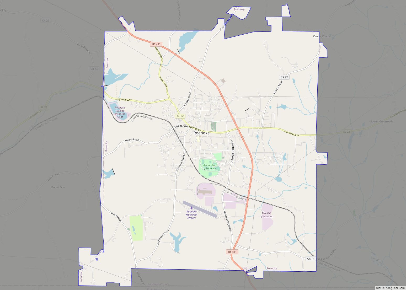
Roanoke is a city in Randolph County, which is in the Piedmont region of eastern Alabama, United States. As of the 2020 census, the population of the city was 5,311, down from 6,074 in 2010 and 6,563 in 2000. Roanoke city overview: Name: Roanoke city LSAD Code: 25 LSAD Description: city (suffix) State: Alabama County: … Read more

Map of Riverview town

Map of Riverview town, Alabama

Riverview is a town in Escambia County, Alabama, United States. At the 2010 census the population was 184, up from 99 at the 2000 census. Riverview town overview: Name: Riverview town LSAD Code: 43 LSAD Description: town (suffix) State: Alabama County: Escambia County Elevation: 72 ft (22 m) Total Area: 1.47 sq mi (3.80 km²) Land Area: 1.45 sq mi (3.75 km²) Water … Read more

Map of Riverside city

Map of Riverside city, Alabama

Riverside is a city in St. Clair County, Alabama, United States. It incorporated in 1886. At the 2010 census the population was 2,208, up from 1,564 in 2000. Riverside city overview: Name: Riverside city LSAD Code: 25 LSAD Description: city (suffix) State: Alabama County: St. Clair County Elevation: 505 ft (154 m) Total Area: 10.41 sq mi (26.96 km²) Land … Read more

Map of Rock Mills CDP

Map of Rock Mills CDP

Rock Mills is a census-designated place (CDP) in Randolph County, Alabama, United States. At the 2010 census the population was 600, down from 676 in 2000. According to the U.S. Census, from 1890 until the 1920s, Rock Mills was an incorporated community. It was later designated a CDP beginning in 2000. Rock Mills CDP overview: … Read more

Map of Rock Creek CDP

Map of Rock Creek CDP, Alabama

Rock Creek is a census-designated place in Jefferson County, Alabama, United States. Its location is northwest of Hueytown. At the 2020 census, the population was 1,471. This area was damaged by an F5 tornado on April 8, 1998. An EF2 tornado struck northwest from here on January 23, 2012. Rock Creek CDP overview: Name: Rock … Read more

Map of Robertsdale city

Map of Robertsdale city

Robertsdale is a city in Baldwin County, Alabama, United States, which includes the community of Rosinton. At the 2020 census, the population was 6,708. It is part of the Daphne-Fairhope-Foley metropolitan area. Robertsdale city overview: Name: Robertsdale city LSAD Code: 25 LSAD Description: city (suffix) State: Alabama County: Baldwin County Incorporated: 1921 Elevation: 148 ft (45 m) … Read more

Map of Rogersville town

Map of Rogersville town, Alabama

Rogersville is a town in Lauderdale County, Alabama, United States. As of the 2018 census, the population of the town is 1,231, up from 1,199 in 2000. Rogersville town overview: Name: Rogersville town LSAD Code: 43 LSAD Description: town (suffix) State: Alabama County: Lauderdale County Elevation: 646 ft (197 m) Total Area: 3.03 sq mi (7.86 km²) Land Area: 3.03 sq mi … Read more

Map of Rockville CDP

Map of Rockville CDP, Alabama

Rockville is a census-designated place and in Clarke County, Alabama, United States. Its population was 47 as of the 2020 census. Rockville CDP overview: Name: Rockville CDP LSAD Code: 57 LSAD Description: CDP (suffix) State: Alabama County: Clarke County Elevation: 308 ft (94 m) Total Area: 2.81 sq mi (7.27 km²) Land Area: 2.81 sq mi (7.27 km²) Water Area: 0.00 sq mi (0.00 km²) Total … Read more

Map of Rockford city

Map of Rockford town, Alabama

Rockford is a town in Coosa County, Alabama, United States. At the 2020 census, the population was 349. The town is the county seat of Coosa County and is part of the Talladega-Sylacauga Micropolitan Statistical Area. Rockford town overview: Name: Rockford town LSAD Code: 43 LSAD Description: town (suffix) State: Alabama County: Coosa County Elevation: … Read more

Map of Rutledge town

Map of Rutledge town, Alabama

Rutledge is a town in Crenshaw County, Alabama, United States. As of the 2010 census, the population of the town was 467. Rutledge town overview: Name: Rutledge town LSAD Code: 43 LSAD Description: town (suffix) State: Alabama County: Crenshaw County Elevation: 344 ft (105 m) Total Area: 5.86 sq mi (15.18 km²) Land Area: 5.86 sq mi (15.18 km²) Water Area: 0.00 sq mi (0.00 km²) … Read more

Map of Russellville city

Map of Russellville city, Alabama

Russellville is a city in Franklin County in the U.S. state of Alabama. At the 2020 census, the population of the city was 10,855, up from 9,830 at the 2010 census. The city is the county seat of Franklin County. Russellville city overview: Name: Russellville city LSAD Code: 25 LSAD Description: city (suffix) State: Alabama … Read more

Map of Rosa town

Map of Rosa town

Rosa is a town in Blount County, Alabama, United States. At the 2020 census, the population was 376. Rosa town overview: Name: Rosa town LSAD Code: 43 LSAD Description: town (suffix) State: Alabama County: Blount County Elevation: 620 ft (190 m) Total Area: 4.20 sq mi (10.88 km²) Land Area: 4.19 sq mi (10.86 km²) Water Area: 0.01 sq mi (0.02 km²) Total Population: 376 Population … Read more