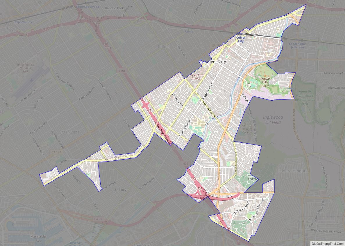
Map of Cypress city

Map of Cypress city, California

Cypress is a city in northwestern Orange County within Southern California. Its population was 50,151 at the 2020 census. Cypress city overview: Name: Cypress city LSAD Code: 25 LSAD Description: city (suffix) State: California County: Orange County Incorporated: July 24, 1956 Elevation: 39 ft (12 m) Total Area: 6.62 sq mi (17.15 km²) Land Area: 6.61 sq mi (17.13 km²) Water Area: 0.01 sq mi … Read more

Map of Cuyama CDP

Map of Cuyama CDP

Cuyama (/kwiːˈjɑːmə/; (Chumash: Kuyam, meaning “Clam”)) is a census-designated place in Santa Barbara County. California. It is located in the Cuyama Valley, near the Carrizo Plain. The Cuyama River runs adjacent to the town, flowing west towards the Pacific Ocean. Cuyama is surrounded by many apricot, peach, and plum orchards. The ZIP Code is 93254, … Read more

Map of Cutten CDP

Map of Cutten CDP

Cutten, a census-designated place (CDP) in Humboldt County, California, United States, is an unincorporated community, which is part of Greater Eureka. The city was named for David Page Cutten and his family, who were prominent figures in the history of Humboldt County during the early 1850s. Cutten is located 2.5 miles (4 km) south-southeast of downtown … Read more

Map of Dana Point city

Map of Dana Point city

Dana Point (/ˌdeɪnə-/) is a city located in southern Orange County, California, United States. The population was 33,107 at the 2020 census. It has one of the few harbors along the Orange County coast, and with ready access via State Route 1, it is a popular local destination for surfing. The city was named after … Read more

Map of Daly City city

Map of Daly City

Daly City (/ˈdeɪli/) is the second most populous city in San Mateo County, California, United States, with population of 104,901 according to the 2020 census. Located in the San Francisco Bay Area, and immediately south of San Francisco (sharing its northern border with almost all of San Francisco’s southern border), it is named for businessman … Read more

Map of Danville town, California

Map of Danville town, California

The Town of Danville is located in the San Ramon Valley in Contra Costa County, California. It is one of the incorporated municipalities in California that use “town” in their names instead of “city”. The population was 43,582 at the 2020 census. Since 2018, for four years in a row, Danville was named “the safest … Read more

Map of Davenport city

Map of Davenport CDP, California

Davenport is a census-designated place (CDP) in Santa Cruz County, California. Davenport sits at an elevation of 259 feet (79 m). The 2020 United States census reported Davenport’s population was 388. Davenport CDP overview: Name: Davenport CDP LSAD Code: 57 LSAD Description: CDP (suffix) State: California County: Santa Cruz County Elevation: 259 ft (79 m) Total Area: 2.85 sq mi … Read more

Map of Darwin CDP

Map of Darwin CDP, California

Darwin is an unincorporated mining community in Inyo County, California, United States. It is located 22 miles (35 km) southeast of Keeler, at an elevation of 4,790 ft (1,460 m). The population was 43 at the 2010 census, down from 54 at the 2000 census. Darwin CDP overview: Name: Darwin CDP LSAD Code: 57 LSAD Description: CDP (suffix) … Read more

Map of Daphnedale Park CDP

Map of Daphnedale Park CDP

Daphnedale Park is a census-designated place in Modoc County, California. It is located 1.5 miles (2.4 km) north of Alturas, at an elevation of 4449 feet (1356 m). Its population is 129 as of the 2020 census, down from 184 from the 2010 census. Daphnedale Park CDP overview: Name: Daphnedale Park CDP LSAD Code: 57 LSAD … Read more

Map of Deer Park CDP, California

Map of Deer Park CDP, California

Deer Park is a census-designated place (CDP) in Napa County, California, United States. The population was 1,267 at the 2010 census. It is part of the Napa, California Metropolitan Statistical Area. Its area code is 707. Its zip code is 94576. It is in the Pacific time zone. Deer Creek is where Elmshaven, a large … Read more

Map of Day Valley CDP

Map of Day Valley CDP

Day Valley is a census-designated place (CDP) in Santa Cruz County, California, United States. The population was 3,409 at the 2010 census. Day Valley CDP overview: Name: Day Valley CDP LSAD Code: 57 LSAD Description: CDP (suffix) State: California County: Santa Cruz County Elevation: 1,316 ft (401 m) Total Area: 18.50 sq mi (47.92 km²) Land Area: 18.50 sq mi (47.92 km²) Water … Read more

Map of Davis city

Map of Davis city, California

Davis is the most populous city in Yolo County, California. Located in the Sacramento Valley region of Northern California, the city had a population of 66,850 in 2020, not including the on-campus population of the University of California, Davis, which was over 9,400 (not including students’ families) in 2016. As of 2019, there were 38,369 … Read more