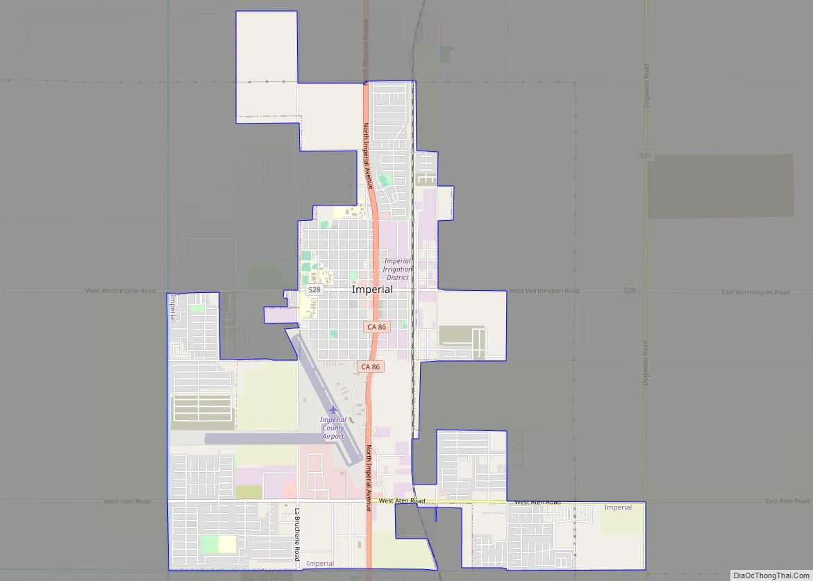
Map of Indio Hills CDP

Map of Indio Hills CDP

Indio Hills is a census-designated place in Riverside County, California. Indio Hills sits at an elevation of 1,017 feet (310 m). The 2010 United States census reported Indio Hills’s population was 972. Indio Hills CDP overview: Name: Indio Hills CDP LSAD Code: 57 LSAD Description: CDP (suffix) State: California County: Riverside County Elevation: 1,017 ft (310 m) Total … Read more

Map of Indianola CDP

Map of Indianola CDP, California

Indianola is a census-designated place in Humboldt County, California. It is located 4 miles (6.4 km) south of Arcata, at an elevation of 46 feet (14 m). The place appears on the USGS Arcata South map. Addresses in this neighborhood are part of unincorporated Eureka, California, located entirely within the 95503 ZIP code. The population was … Read more

Map of Indian Wells city, California

Map of Indian Wells city, California

Indian Wells is a city in Riverside County, California, United States, in the Coachella Valley. Incorporated in 1967, it lies in between the cities of Palm Desert and La Quinta. As of the 2010 Census, the city population was 4,958. The city hosts the sixth-largest tennis tournament in the world, the Indian Wells Masters tennis … Read more

Map of Inglewood city

Map of Inglewood city, California

Inglewood is a city in southwestern Los Angeles County, California, United States, in the Los Angeles metropolitan area. As of the 2020 U.S. Census, the city had a population of 107,762. It was incorporated on February 14, 1908. The city is in the South Bay region of Los Angeles County, near Los Angeles International Airport. … Read more

Map of Industry city

Map of Industry city, California

The City of Industry is a city in the San Gabriel Valley, in eastern Los Angeles County, California, United States. The city is almost entirely industrial, containing over 3,000 businesses employing 67,000 people, with only 264 residents as of the 2020 census, making it the third least populous city in the state. It was incorporated … Read more

Map of Indio city

Map of Indio city, California

Indio (Spanish for “Indian”) is a city in Riverside County, California, United States, in the Coachella Valley of Southern California’s Colorado Desert region. It lies 23 miles (37 km) east of Palm Springs, 75 miles (121 km) east of Riverside, 127 miles (204 km) east of Los Angeles, 148 miles (238 km) northeast of San Diego, and 250 miles … Read more

Map of Inyokern CDP

Map of Inyokern CDP

Inyokern (formerly Siding 16 and Magnolia) is a census-designated place (CDP) in Kern County, California, United States. Its name derives from its location near the border between Inyo and Kern Counties. Inyokern is located 8 miles (13 km) west of Ridgecrest, at an elevation of 2,434 feet (742 m). It is on the western side of the … Read more

Map of Inverness CDP

Map of Inverness CDP, California

Inverness is an unincorporated community and census-designated place (CDP) in western Marin County, California, United States. It is located on the southwest shore of Tomales Bay 3.5 miles (5.6 kilometers) northwest of Point Reyes Station and about 40 miles (64 km) by road northwest of San Francisco, at an elevation of 43 feet (13 meters). In … Read more

Map of Interlaken CDP

Map of Interlaken CDP, California

Interlaken is a census-designated place (CDP) in Santa Cruz County, California, United States. The population was 7,368 at the 2020 census. Interlaken CDP overview: Name: Interlaken CDP LSAD Code: 57 LSAD Description: CDP (suffix) State: California County: Santa Cruz County Elevation: 128 ft (39 m) Total Area: 10.202 sq mi (26.423 km²) Land Area: 9.805 sq mi (25.396 km²) Water Area: 0.397 sq mi (1.027 km²) … Read more

Map of Irwindale city

Map of Irwindale city

Irwindale is a city in the San Gabriel Valley, in Los Angeles County, California. The population was 1,422 at the 2010 census, down from 1,446 at the 2000 census. The ZIP Codes serving the area are 91010, which is shared with Duarte, 91702, which is shared with Azusa, and 91706, which is shared with Baldwin … Read more

Map of Iron Horse CDP

Map of Iron Horse CDP

Iron Horse is a census-designated place (CDP) in Plumas County, California, United States. The population was 297 at the 2010 census, down from 321 at the 2000 census. Iron Horse CDP overview: Name: Iron Horse CDP LSAD Code: 57 LSAD Description: CDP (suffix) State: California County: Plumas County Elevation: 4,944 ft (1,507 m) Total Area: 7.747 sq mi (20.065 km²) … Read more

Map of Ione city

Map of Ione city, California

Ione (/aɪˈoʊn/ eye-OWN) is a city in Amador County, California. The population was 7,918 at the 2010 census, up from 7,129 in 2000. Once known as “Bed-Bug” and “Freeze Out,” Ione was an important supply center on the main road to the Mother Lode and Southern Mines during the California Gold Rush. Ione city overview: … Read more