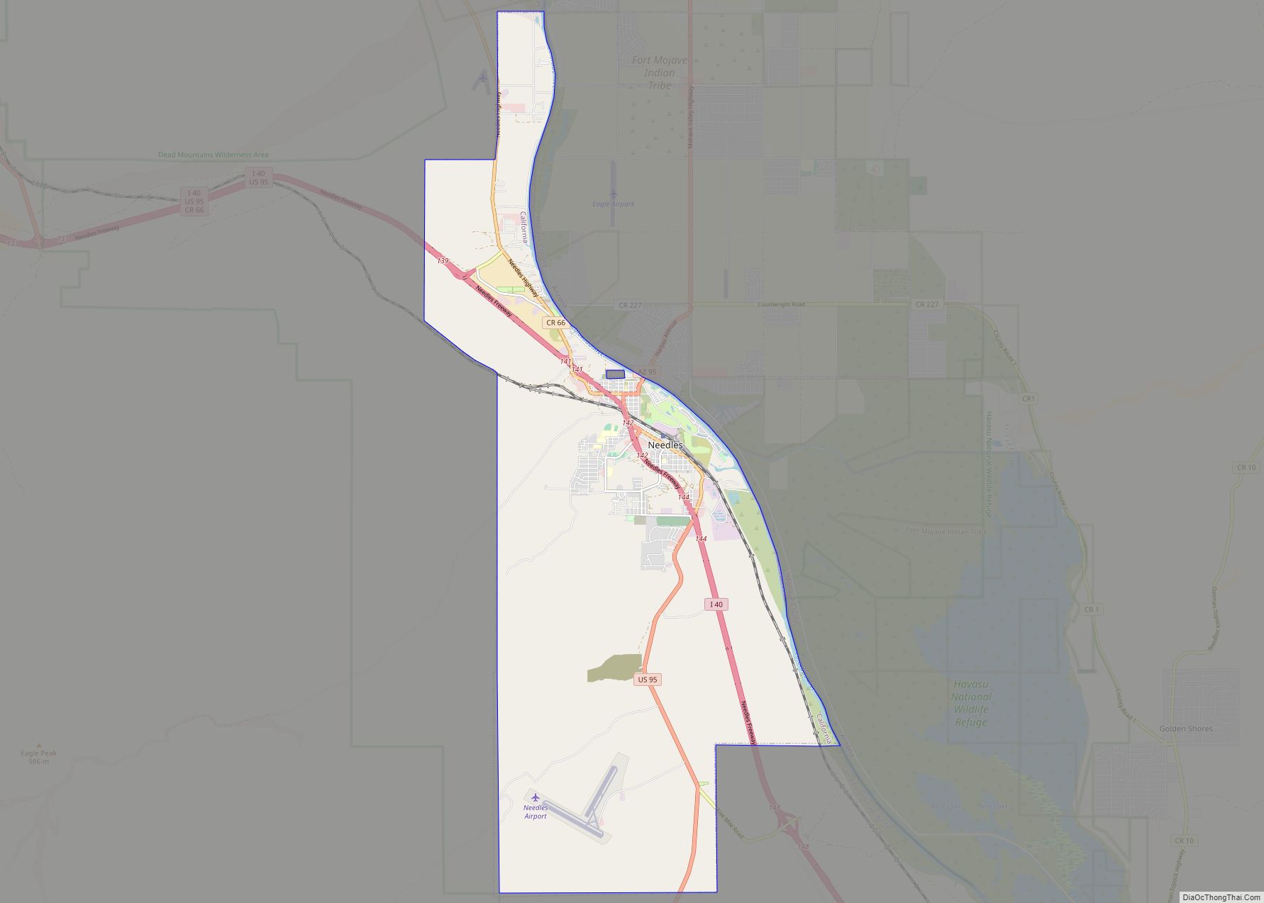
Map of New Pine Creek CDP

Map of New Pine Creek CDP, California

New Pine Creek (formerly, Pine Creek) is a census-designated place in Modoc County, California. It is located on the Oregon border 7 miles (11 km) north-northeast of Willow Ranch, at an elevation of 4842 feet (1476 m). Its population is 87 as of the 2020 census, down from 98 from the 2010 census. A 1913 book … Read more

Map of New Cuyama CDP

Map of New Cuyama CDP

New Cuyama (Chumash: Kuyam, meaning “Clam”) is a census-designated place in the Cuyama Valley, Santa Barbara County, California. It was named after the Chumash word for “clams”, most likely due to the millions of petrified prehistoric clamshell fossils that are found in the surrounding areas. The town is home to the majority of the utility … Read more

Map of Nevada City city

Map of Nevada City

Nevada City (originally, Ustumah, a Nisenan village; later, Nevada, Deer Creek Dry Diggins, and Caldwell’s Upper Store) is the county seat of Nevada County, California, United States, 60 miles (97 km) northeast of Sacramento, 84 miles (135 km) southwest of Reno and 147 miles (237 km) northeast of San Francisco. The population was 3,068 as of the 2010 … Read more

Map of Newell CDP

Map of Newell CDP, California

Newell is a census-designated place in Modoc County, California in the United States. It is located 50 miles (80 km) west-northwest of Alturas, at an elevation of 4,042 feet (1,232 m). Its population is 301 as of the 2020 census, down from 449 from the 2010 census. The community is located along State Route 139 south of … Read more

Map of Newcastle CDP

Map of Newcastle CDP, California

Newcastle is an unincorporated community and census-designated place (CDP) in Placer County, California. Nestled in the Sierra Nevada foothills, Newcastle is located 8 miles (12.9 km) northeast of Rocklin and 31 miles northeast of Sacramento. Newcastle generally has moderate winters and warm summers. The latitude of Newcastle is 38.874N, the longitude is -121.132W, and an elevation … Read more

Map of Newark city, California

Map of Newark city, California

Newark is a city in Alameda County, California, United States. It was incorporated as a city in September 1955. Newark is an enclave, surrounded by the city of Fremont. The three cities of Newark, Fremont, and Union City make up the Tri-City Area. Newark’s population was 47,529 at the 2020 census making it the third … Read more

Map of Newport Beach city

Map of Newport Beach city

Newport Beach is a coastal city of about 85,000 in southern Orange County, California, United States. Newport Beach is known for swimming and sandy beaches. Newport Harbor once supported maritime industries; however today it is used mostly for recreation. Balboa Island draws visitors with a waterfront path and easy access from the ferry to the … Read more

Map of Newman city

Map of Newman city, California

Newman is a city in Stanislaus County, California, located in the San Joaquin Valley region of the greater Central Valley. The city had a population of 10,224 at the 2010 census, up from 7,093 at the 2000 census. Founded in 1888 by Simon Newman, the city is a largely agricultural community, known for its annual … Read more

Map of Nicasio CDP

Map of Nicasio CDP

Nicasio (/nɪˈkɑːsi.oʊ/ nih-KAH-see-oh; Spanish for “Nicasius”) is an unincorporated community and census-designated place in Marin County, California, United States. It is located 8 miles (13 km) west-southwest of Novato, at an elevation of 194 feet (59 m). As of the 2020 census the CDP population was 81, while population estimates for the surrounding area range from about … Read more

Map of Niland CDP

Map of Niland CDP

Niland (formerly Old Beach, Imperial Junction, and Hobgood) is a census-designated place (CDP) in Imperial County, California, United States. The town is located 8 miles (13 km) north of Calipatria, 2 miles (3.2 km) southeast of the Salton Sea. The population was 1,006 at the 2010 census, down from 1,143 in 2000. The 2020 census reported Niland’s … Read more

Map of Nicolaus CDP

Map of Nicolaus CDP

Nicolaus is a census-designated place (CDP) in Sutter County, California. Nicolaus is part of the Yuba City Metropolitan Statistical Area. Nicolaus sits at an elevation of 26 feet (7.9 m). The 2010 United States census reported Nicolaus’s population was 211. It is named after Nicolaus Allgeier, local rancher. The town’s former names included Nicolaus Ferry and … Read more

Map of Nice CDP

Map of Nice CDP

Nice is a census-designated place (CDP) in Lake County, California, United States. Nice is located 4.5 miles (7.2 km) southeast of Upper Lake, at an elevation of 1362 feet (415 m). The population was 2,731 at the 2010 census, up from 2,509 at the 2000 census. Nice CDP overview: Name: Nice CDP LSAD Code: 57 LSAD … Read more