Newport Beach is a coastal city of about 85,000 in southern Orange County, California, United States. Newport Beach is known for swimming and sandy beaches. Newport Harbor once supported maritime industries; however today it is used mostly for recreation. Balboa Island draws visitors with a waterfront path and easy access from the ferry to the shops and restaurants.
| Name: | Newport Beach city |
|---|---|
| LSAD Code: | 25 |
| LSAD Description: | city (suffix) |
| State: | California |
| County: | Orange County |
| Incorporated: | September 1, 1906 |
| Elevation: | 10 ft (3 m) |
| Total Area: | 52.92 sq mi (137.07 km²) |
| Land Area: | 23.79 sq mi (61.62 km²) |
| Water Area: | 29.13 sq mi (75.45 km²) 55.07% |
| Total Population: | 85,239 |
| Population Density: | 1,600/sq mi (620/km²) |
| Area code: | 949 |
| FIPS code: | 0651182 |
| Website: | newportbeachca.gov |
Online Interactive Map
Click on ![]() to view map in "full screen" mode.
to view map in "full screen" mode.
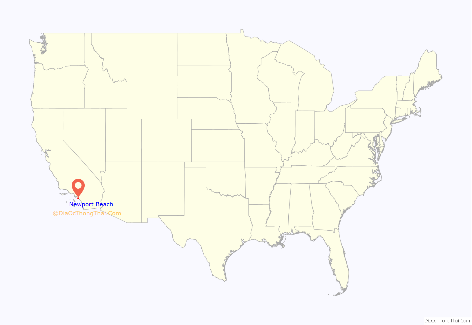
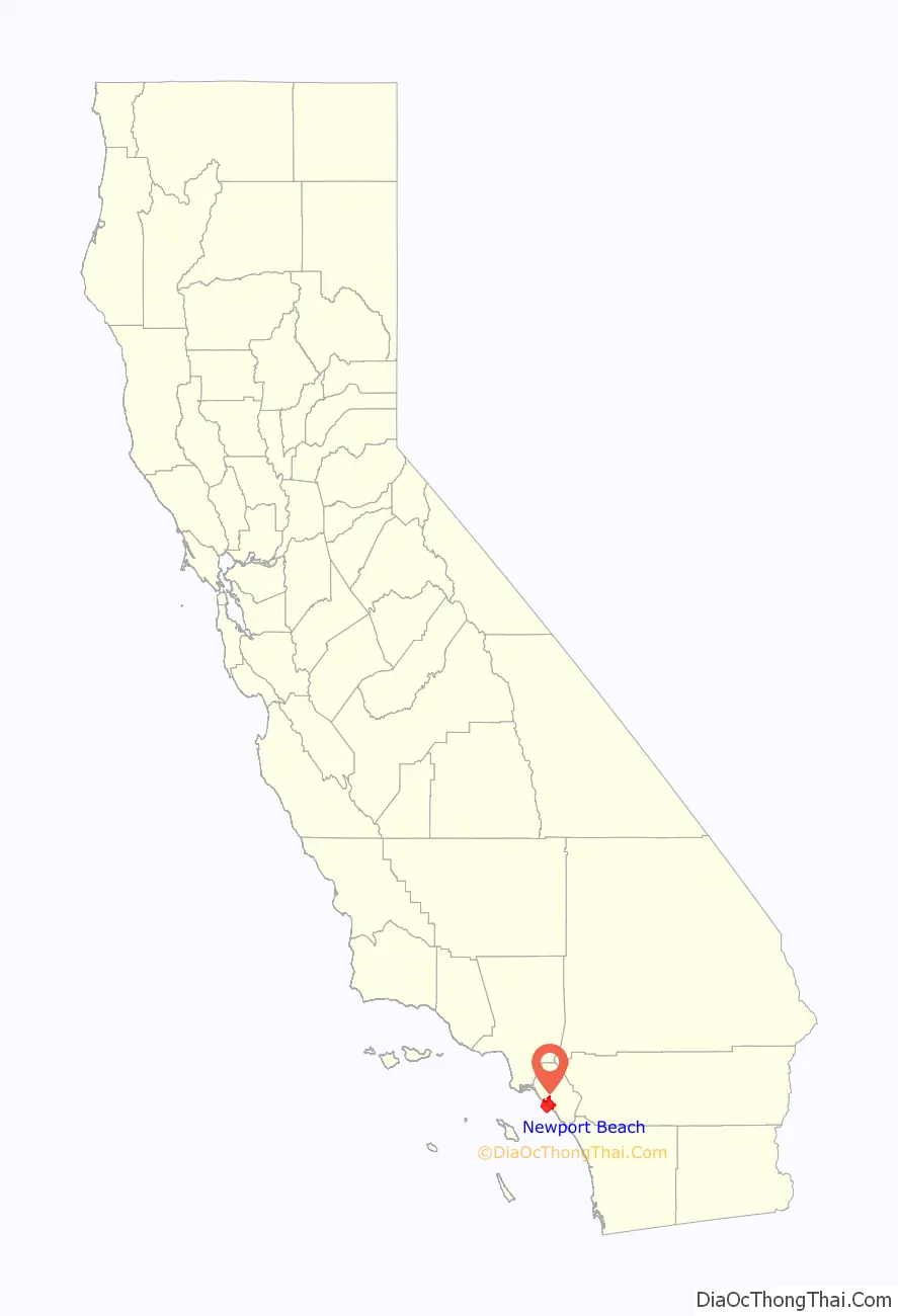
Newport Beach location map. Where is Newport Beach city?
History
The Upper Bay of Newport is a canyon carved by a stream in the Pleistocene period. The Lower Bay of Newport was formed much later by sand brought along by ocean currents, which constructed the offshore beach now recognized as the Balboa Peninsula of Newport Beach.
For thousands of years, the Tongva people lived on the land in an extensive, thriving community. The Tongva villages of Genga and Moyongna were located in Newport Beach. Throughout the 1800s, Europeans colonized the land and forcibly removed and assimilated the Tongva. Present-day Newport Beach exists upon the unceded homelands of the Tongva people, and they have a historical and continued presence as the traditional caretakers of the land.
The State of California sold acre-plots of land for $1 a piece in the Newport area. Anglo-American inhabitation in the area grew substantially following 1870 when a 105-ton steamer named The Vaquero, captained by Captain Samuel S. Dunnells (against warnings posted by surveyors), safely steered through the lower and upper bay of Newport where it unloaded its cargo. James Irvine upon hearing the astonishing news, quickly traveled from his home in San Francisco to the San Joaquin Ranch. Meeting in Irvine’s ranch house near current day UC Irvine with his brother, Robert Irvine, and friend James McFadden, they agreed that the newly found port should be simply named “Newport” which is where Newport Beach gets its name. James McFadden built a long McFadden Wharf in 1888.
In 1905, city development increased when Pacific Electric Railway established a southern terminus in Newport connecting the beach with downtown Los Angeles. In 1906 (with a population of 206 citizens), the scattered settlements were incorporated as the City of Newport Beach.
Settlements were filled in on the Peninsula, West Newport, Newport Island, Balboa Island, and Lido Isle. In 1923, Corona del Mar was annexed and in 2002, Newport Coast, East Santa Ana Heights, and San Joaquin Hills were annexed. In 2008, after a long battle with the city of Costa Mesa, Newport Beach annexed West Santa Ana Heights.
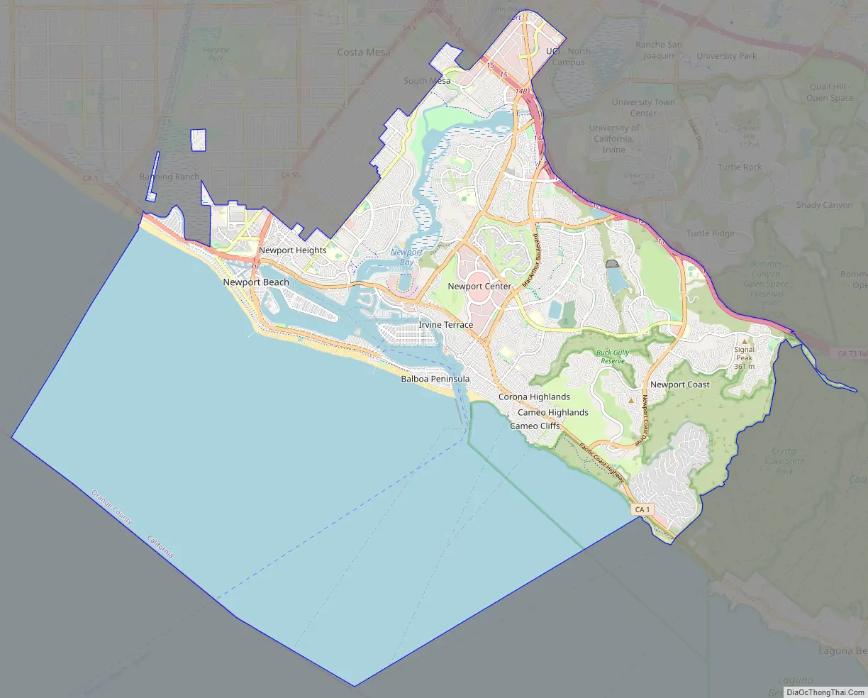
Newport Beach Road Map
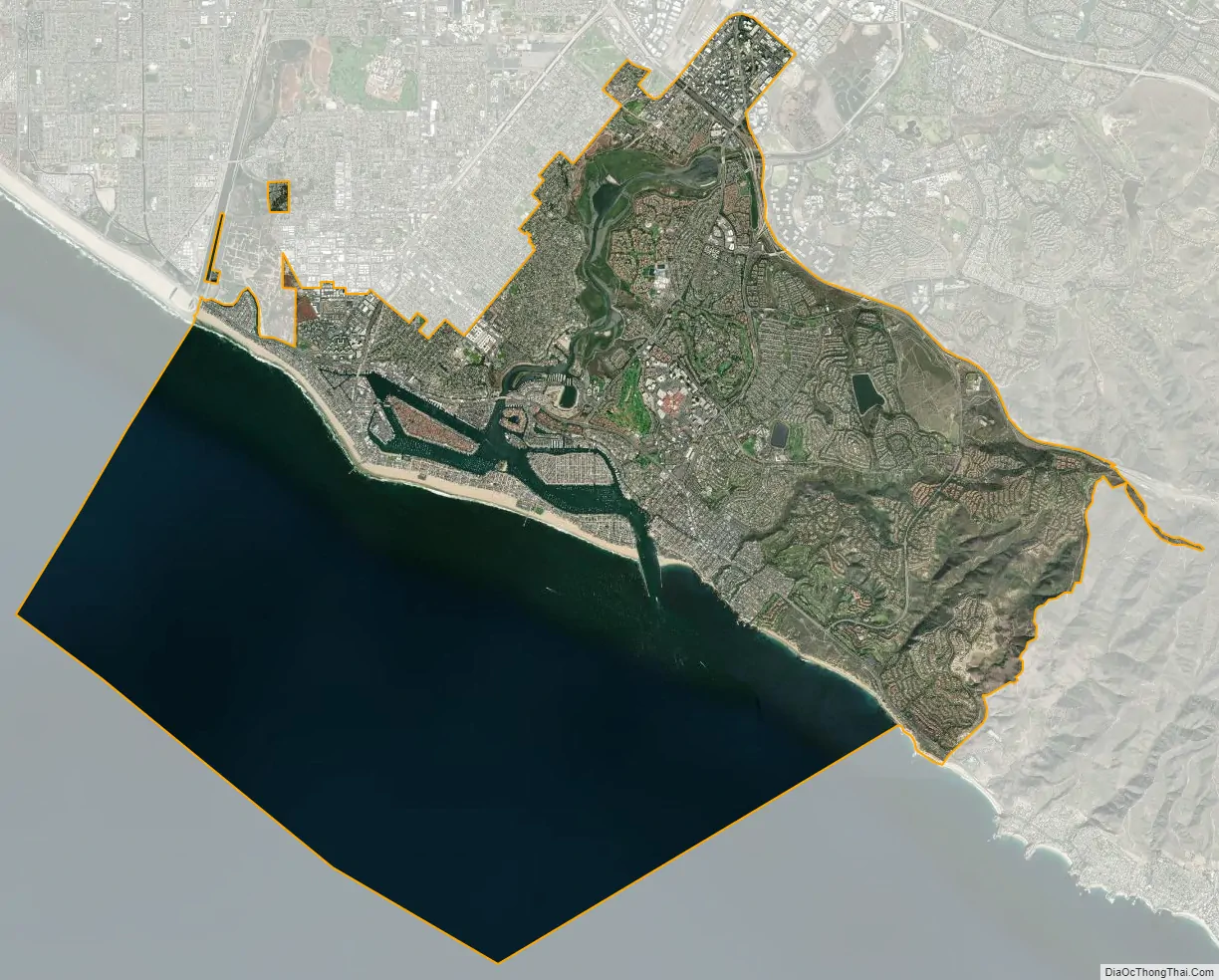
Newport Beach city Satellite Map
Geography
Newport Beach extends in elevation from sea level to the 1,161 ft (354 m) summit of Signal Peak in the San Joaquin Hills, but the official elevation is 25 ft (7.6 m) above sea level at a location of 33°37′0″N 117°53′51″W / 33.61667°N 117.89750°W / 33.61667; -117.89750 (33.616671, −117.897604).
The city is bordered on the west by Huntington Beach at the Santa Ana River; on the north by Costa Mesa, John Wayne Airport, the City of Irvine and UC Irvine; and on the east by Crystal Cove State Park.
According to the United States Census Bureau, the city has a total area of 53.0 square miles (137 km). 23.8 square miles (62 km) of it is land and 29.2 square miles (76 km) of it (55.07%) is water.
Areas of Newport Beach include Corona del Mar, Balboa Island, Balboa Peninsula (also known as Balboa), Lido Peninsula, Newport Coast, San Joaquin Hills, Santa Ana Heights, and West Newport.
Newport Harbor and Newport Bay
Newport Harbor is a semi-artificial harbor that was formed by dredging Newport Bay estuary during the early 1900s. Several artificial islands were built, which are now covered with private homes: Newport Island, Balboa Island, Little Balboa Island, Collins Island, Bay Island, Harbor Island, Lido Isle, and Linda Isle.
Newport Harbor once supported maritime industries such as boatbuilding, shipbuilding, and commercial fishing, but today it is used mostly for recreation. Its shores are occupied mostly by private homes and private docks. Newport Harbor has approximately 9,000 boats and is one of the largest recreational boat harbors on the U.S. west coast. It is a popular destination for all boating activities, including sailing, fishing, rowing, canoeing, kayaking, and paddleboarding.
Commercial maritime operations today include the Catalina Flyer ferry to Catalina Island, harbor tours, sport fishing, whale watching day trips, and charters as well as a few small commercial fishing boats.
Newport Bay is divided by the Pacific Coast Highway bridge, which is too low for most sailboats and very large boats to pass under. North of the bridge is referred to as Upper Newport Bay, or the Back Bay. South of the bridge is commonly called Lower Newport Bay, or Newport Harbor. However the Back Bay also has harbor facilities, especially the marina and launch ramp at Newport Dunes Marina.
The north end of the Newport Harbor channels surrounding Lido Isle has several small business centers and was at one time used as a home by the fishing fleets. On the North East side of the channel, the Lido Marina Village now acts as the local port to many “Newport Party Boats” that can be rented for events, as well as small merchants and local restaurants. It also hosts the area boat show each year, and an organic “Farmers Market” on Sundays, in addition to being the port for the local Gondola Company. In 2014, the center was closed for a renovation. The Lido Village was reopened in 2017 after a complete renovation.
In 1927, a home was built at the mouth of the entrance of Newport Harbor that came to be known as the China House of China Cove. The home was built using traditional Chinese architecture. It was a landmark in the Newport Beach Harbor until it was demolished in the 1980s. Some of the original roof can be seen on a home located in the China Cove.
Upper Newport Bay is an estuary that was formed by a prehistoric flow of the Santa Ana River. Today it is fed by a small stream from San Diego Creek. Much of Upper Newport Bay is a protected natural area known as the Upper Newport Bay Ecological Reserve, established in 1975.
Climate
Newport Beach has a mid-latitude semi-arid climate (Köppen climate classification BSk) with characteristics of a warm-summer Mediterranean climate (Köppen: Csb). Like many Los Angeles and Orange coastal cities, Newport Beach exhibits weak temperature variation, diurnally and seasonally, compared to inland cities even a few miles from the ocean. The Pacific Ocean greatly moderates Newport Beach’s climate by warming winter temperatures and cooling summer temperatures. Diurnal temperature variation is stronger during the winter than during the summer. Newport Beach does not receive enough precipitation to qualify as a true Mediterranean climate.
See also
Map of California State and its subdivision:- Alameda
- Alpine
- Amador
- Butte
- Calaveras
- Colusa
- Contra Costa
- Del Norte
- El Dorado
- Fresno
- Glenn
- Humboldt
- Imperial
- Inyo
- Kern
- Kings
- Lake
- Lassen
- Los Angeles
- Madera
- Marin
- Mariposa
- Mendocino
- Merced
- Modoc
- Mono
- Monterey
- Napa
- Nevada
- Orange
- Placer
- Plumas
- Riverside
- Sacramento
- San Benito
- San Bernardino
- San Diego
- San Francisco
- San Joaquin
- San Luis Obispo
- San Mateo
- Santa Barbara
- Santa Clara
- Santa Cruz
- Shasta
- Sierra
- Siskiyou
- Solano
- Sonoma
- Stanislaus
- Sutter
- Tehama
- Trinity
- Tulare
- Tuolumne
- Ventura
- Yolo
- Yuba
- Alabama
- Alaska
- Arizona
- Arkansas
- California
- Colorado
- Connecticut
- Delaware
- District of Columbia
- Florida
- Georgia
- Hawaii
- Idaho
- Illinois
- Indiana
- Iowa
- Kansas
- Kentucky
- Louisiana
- Maine
- Maryland
- Massachusetts
- Michigan
- Minnesota
- Mississippi
- Missouri
- Montana
- Nebraska
- Nevada
- New Hampshire
- New Jersey
- New Mexico
- New York
- North Carolina
- North Dakota
- Ohio
- Oklahoma
- Oregon
- Pennsylvania
- Rhode Island
- South Carolina
- South Dakota
- Tennessee
- Texas
- Utah
- Vermont
- Virginia
- Washington
- West Virginia
- Wisconsin
- Wyoming


