Map of Evergreen CDP, Colorado

Map of Evergreen CDP, Colorado

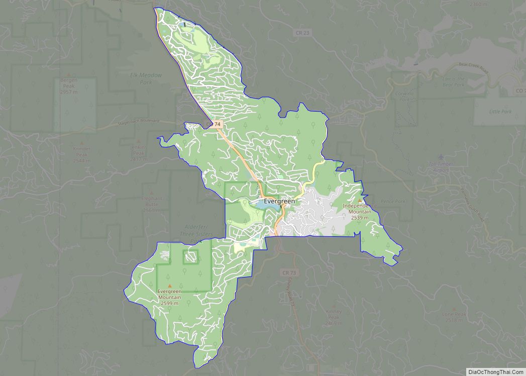
Evergreen is an unincorporated town, a post office, and a census-designated place (CDP) located in and governed by Jefferson County, Colorado, U.S. The CDP is a part of the Denver–Aurora–Lakewood, CO Metropolitan Statistical Area. The Evergreen post office has the ZIP Codes 80439 and 80437 (for post office boxes). At the 2020 census, the population … Read more

Map of Evans city

Map of Evans city, Colorado

The City of Evans is a home rule municipality located in Weld County, Colorado, United States. The city population was 22,165 at the 2020 United States Census, a 19.57% increase since the 2010 United States Census. Evans is a part of the Greeley, CO Metropolitan Statistical Area and the Front Range Urban Corridor. Evans city … Read more

Map of Fairplay town

Map of Fairplay town, Colorado

The historic Town of Fairplay is the Statutory Town that is the county seat and the most populous municipality of Park County, Colorado, United States. The town population was 724 at the 2020 United States Census. Fairplay is located in South Park at an elevation of 9,953 feet (3,034 m). The town is the fifth-highest incorporated … Read more

Map of Firestone town

Map of Firestone town

The Town of Firestone is a Statutory Town in southwestern Weld County, Colorado, United States. The town population was 16,381 at the 2020 United States Census, a 61.44% increase since the 2010 United States Census. Firestone is a part of the Greeley, CO Metropolitan Statistical Area and the Front Range Urban Corridor. Firestone town overview: … Read more

Map of Federal Heights city

Map of Federal Heights city

The City of Federal Heights is a home rule municipality located in western Adams County, Colorado, United States. The city population was 14,382 at the 2020 United States Census, a +25.42% increase since the 2010 United States Census. Federal Heights is a part of the Denver–Aurora–Lakewood, CO Metropolitan Statistical Area and the Front Range Urban … Read more

Map of Florence city, Colorado

Map of Florence city, Colorado

The City of Florence is a Statutory City located in Fremont County, Colorado, United States. The city population was 3,822 at the 2020 United States Census. Florence is a part of the Cañon City, CO Micropolitan Statistical Area and the Front Range Urban Corridor. Florence city overview: Name: Florence city LSAD Code: 25 LSAD Description: … Read more

Map of Fleming town

Map of Fleming town, Colorado

The Town of Fleming is a Statutory Town in Logan County, Colorado, United States. The town population was 428 at the 2020 United States Census. Fleming is a part of the Sterling, CO Micropolitan Statistical Area. Fleming town overview: Name: Fleming town LSAD Code: 43 LSAD Description: town (suffix) State: Colorado County: Logan County Elevation: … Read more

Map of Flagler town

Map of Flagler town

The Town of Flagler is a Statutory Town in western Kit Carson County, Colorado, United States. The town population was 567 at the 2020 United States Census. Flagler is near Exit 395 on I-70 and about 120 miles east of Denver and Colorado Springs. Flagler town overview: Name: Flagler town LSAD Code: 43 LSAD Description: … Read more

Map of Fort Carson CDP

Map of Fort Carson CDP

Fort Carson is a United States Army post located directly south of Colorado Springs in El Paso, Pueblo, Fremont, and Huerfano counties, Colorado, United States. The developed portion of Fort Carson is located near the City of Colorado Springs in El Paso County. Fort Carson is the home of the 4th Infantry Division, the 10th … Read more

Map of Floyd Hill CDP

Map of Floyd Hill CDP

Floyd Hill is an unincorporated community and a census-designated place (CDP) located in and governed by Clear Creek County, Colorado, United States. The CDP is a part of the Denver–Aurora–Lakewood, CO Metropolitan Statistical Area. The population of the Floyd Hill CDP was 1,048 at the United States Census 2020. The Evergreen post office (Zip Code … Read more

Map of Florissant CDP

Map of Florissant CDP, Colorado

Florissant is an unincorporated town, a post office, and a census-designated place (CDP) located in and governed by Teller County, Colorado, United States. The CDP is a part of the Colorado Springs, CO Metropolitan Statistical Area. The Florissant post office has the ZIP Code 80816. At the United States Census 2020, the population of the … Read more

Map of Fort Morgan city

Map of Fort Morgan city

Fort Morgan is the home rule municipality city that is the county seat and the most populous municipality of Morgan County, Colorado, United States. The city population was 11,597 at the 2020 United States Census. Fort Morgan is the principal city of the Fort Morgan, CO Micropolitan Statistical Area. Fort Morgan city overview: Name: Fort … Read more