Map of Sedgwick town, Colorado

Map of Sedgwick town, Colorado

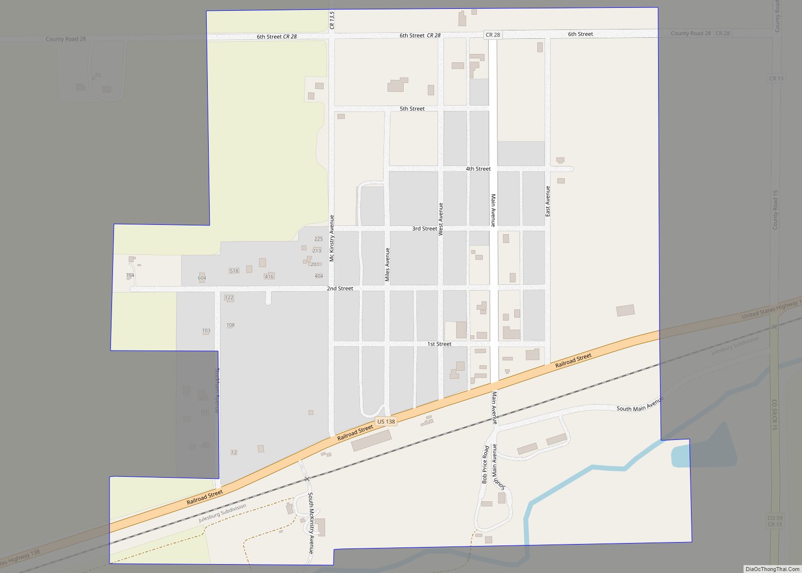
Sedgwick is a statutory town in Sedgwick County, Colorado, United States. The population was 172 at the 2020 census. Sedgwick town overview: Name: Sedgwick town LSAD Code: 43 LSAD Description: town (suffix) State: Colorado County: Sedgwick County Incorporated: January 28, 1918 Elevation: 3,586 ft (1,093 m) Total Area: 0.35 sq mi (0.90 km²) Land Area: 0.35 sq mi (0.90 km²) Water Area: 0.00 sq mi … Read more

Map of Sedalia CDP

Map of Sedalia CDP, Colorado

Sedalia is an unincorporated town, a post office, and a census-designated place (CDP) located in and governed by Douglas County, Colorado, United States. The CDP is a part of the Denver–Aurora–Lakewood, CO Metropolitan Statistical Area. The Sedalia post office has the ZIP Code 80135. At the United States Census 2020, the population of the Sedalia … Read more

Map of Severance town

Map of Severance town, Colorado

Severance is a Statutory Town in Weld County, Colorado, United States. The population was 7683 at the 2020 census. The town is located on the Colorado Eastern Plains, northwest of Greeley, a crossroads of county roads. A post office in Severance has been in operation since 1894. The community was named after David Severance, a … Read more

Map of Seven Hills CDP

Map of Seven Hills CDP, Colorado

Seven Hills is an unincorporated community and a census-designated place (CDP) located in and governed by Boulder County, Colorado, United States. The CDP is a part of the Boulder, CO Metropolitan Statistical Area. The population of the Seven Hills CDP was 129 at the United States Census 2020. The Boulder post office (Zip Code 80302) … Read more

Map of Seibert town

Map of Seibert town

Seibert is a statutory town in Kit Carson County, Colorado, United States. The population was 172 at the 2020 census. A post office called Seibert has been in operation since 1888. The community was named after Henry Seibert, a railroad agent. Seibert town overview: Name: Seibert town LSAD Code: 43 LSAD Description: town (suffix) State: … Read more

Map of Sheridan city, Colorado

Map of Sheridan city, Colorado

The City of Sheridan is a home rule municipality located in Arapahoe County, Colorado, United States. Sheridan is a part of the Denver–Aurora–Lakewood, CO Metropolitan Statistical Area. The population was 6,105 at the 2020 census. Sheridan city overview: Name: Sheridan city LSAD Code: 25 LSAD Description: city (suffix) State: Colorado County: Arapahoe County Incorporated: April, … Read more

Map of Sheridan Lake town

Map of Sheridan Lake town

The Town of Sheridan Lake is a Statutory Town located in Kiowa County, Colorado, United States. The population was 55 at the 2020 census. A post office called “Sheridan Lake” has been in operation since 1887. The community was named after Phil Sheridan, a pioneer hunter. Sheridan Lake town overview: Name: Sheridan Lake town LSAD … Read more

Map of Shaw Heights CDP

Map of Shaw Heights CDP

Shaw Heights is an unincorporated community and a census-designated place (CDP) located in and governed by Adams County, Colorado, United States. The CDP is part of the Denver–Aurora–Lakewood, CO Metropolitan Statistical Area. The population of the Shaw Heights CDP was 5,185 at the United States Census 2020. The Westminster post office (Zip code 80031) serves … Read more

Map of Silver Cliff town

Map of Silver Cliff town

The Town of Silver Cliff is the Statutory Town that is the most populous municipality in Custer County, Colorado, United States. The population was 609 at the 2020 census, up from 587 in 2010. Silver Cliff town overview: Name: Silver Cliff town LSAD Code: 43 LSAD Description: town (suffix) State: Colorado County: Custer County Incorporated: … Read more

Map of Silt town

Map of Silt town

Silt is a Statutory Town in Garfield County, Colorado, United States. The population was 3,536 at the 2020 census, up from 2,930 at the 2010 census. Silt town overview: Name: Silt town LSAD Code: 43 LSAD Description: town (suffix) State: Colorado County: Garfield County Incorporated: May, 1915 Elevation: 5,456 ft (1,663 m) Total Area: 1.73 sq mi (4.47 km²) Land … Read more

Map of Sherrelwood CDP

Map of Sherrelwood CDP

Sherrelwood is an unincorporated community and a census-designated place (CDP) located in and governed by Adams County, Colorado, United States. The CDP is a part of the Denver–Aurora–Lakewood, CO Metropolitan Statistical Area. The population of the Sherrelwood CDP was 19,228 at the United States Census 2020. Sherrelwood CDP overview: Name: Sherrelwood CDP LSAD Code: 57 … Read more

Map of Silverton town

Map of Silverton town, Colorado

Silverton is a statutory town that is the county seat, the most populous community, and the only incorporated municipality in San Juan County, Colorado, United States. The town is located in a remote part of the western San Juan Mountains, a range of the Rocky Mountains. The first mining claims were made in mountains above … Read more