Map of Ward town, Colorado

Map of Ward town, Colorado

Ward is a home rule municipality in Boulder County, Colorado, United States. The population was 150 at the 2010 census. The town is a former mining settlement founded in 1860 in the wake of the discovery of gold at nearby Gold Hill. Once one of the richest towns in the state during the Colorado Gold … Read more

Map of Walsh town

Map of Walsh town

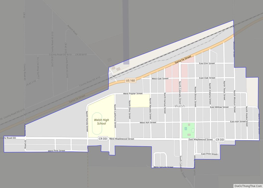
Walsh is a Statutory Town in Baca County, Colorado, United States. The population was 543 at the 2020 census. A post office called Walsh has been in operation since 1926. The community was named after one Mr. Walsh, a railroad official. Walsh town overview: Name: Walsh town LSAD Code: 43 LSAD Description: town (suffix) State: … Read more

Map of Wellington town

Map of Wellington town, Colorado

Wellington is a statutory town in Larimer County, Colorado, United States. The population was 11,047 at the 2020 census. Wellington town overview: Name: Wellington town LSAD Code: 43 LSAD Description: town (suffix) State: Colorado County: Larimer County Founded: 1902 Incorporated: November 10, 1905 Elevation: 5,200 ft (1,585 m) Total Area: 3.63 sq mi (9.41 km²) Land Area: 3.63 sq mi (9.40 km²) Water … Read more

Map of Weldona CDP

Map of Weldona CDP

Weldona is an unincorporated town, a post office, and a census-designated place (CDP) located in and governed by Morgan County, Colorado, United States. The CDP is a part of the Fort Morgan, CO Micropolitan Statistical Area. The Weldona post office has the ZIP Code 80653. At the United States Census 2020, the population of the … Read more

Map of Welby CDP

Map of Welby CDP

Welby is an unincorporated community and a census-designated place (CDP) located in and governed by Adams County, Colorado, United States. The CDP is a part of the Denver–Aurora–Lakewood, CO Metropolitan Statistical Area. The population of the Welby CDP was 15,553 at the United States Census 2020. Welby CDP overview: Name: Welby CDP LSAD Code: 57 … Read more

Map of Westcreek CDP

Map of Westcreek CDP

Westcreek is an unincorporated community and a census-designated place (CDP) located in and governed by Douglas County, Colorado, United States. The CDP is a part of the Denver–Aurora–Lakewood, CO Metropolitan Statistical Area. The population of the Westcreek CDP was 120 at the United States Census 2020. The Sedalia post office (Zip Code 80135) serves the … Read more

Map of Westcliffe town

Map of Westcliffe town

Westcliffe is a statutory town that is the county seat of Custer County, Colorado, United States. At the 2020 U.S. Census, the population was 435. Westcliffe town overview: Name: Westcliffe town LSAD Code: 43 LSAD Description: town (suffix) State: Colorado County: Custer County Incorporated: November 21, 1887 Elevation: 7,867 ft (2,398 m) Total Area: 1.24 sq mi (3.20 km²) Land … Read more

Map of West Pleasant View CDP

Map of West Pleasant View CDP

West Pleasant View is an unincorporated community and a census-designated place (CDP) located in and governed by Jefferson County, Colorado, United States. The CDP is a part of the Denver–Aurora–Lakewood, CO Metropolitan Statistical Area. The population of the West Pleasant View CDP was 4,327 at the United States Census 2020. The Pleasant View Metropolitan District … Read more

Map of Wiggins town

Map of Wiggins town, Colorado

Wiggins is a statutory town in Morgan County, Colorado, United States. The population was 1,401 as of the 2020 census, up from 893 at the 2010 census. The community was established in 1882 as the Burlington Railroad depot of “Corona”. Around 1900, Corona was renamed in honor of Oliver P. Wiggins, who had served as … Read more

Map of Wheat Ridge city

Map of Wheat Ridge city

The City of Wheat Ridge is a home rule municipality located in Jefferson County, Colorado, United States. Wheat Ridge is located immediately west of Denver and is a part of the Denver–Aurora–Lakewood, CO Metropolitan Statistical Area. The Wheat Ridge Municipal Center is approximately 5 miles (8 km) west-northwest of the Colorado State Capitol in Denver. The … Read more

Map of Weston CDP

Map of Weston CDP, Colorado

Weston is an unincorporated town, a post office, and a census-designated place (CDP) located in and governed by Las Animas County, Colorado, United States. The Weston post office has the ZIP Code 81091. At the United States Census 2020, the population of the Weston CDP was 53. Weston CDP overview: Name: Weston CDP LSAD Code: … Read more

Map of Windsor town, Colorado

Map of Windsor town, Colorado

Windsor is a home rule municipality in Larimer and Weld counties in the U.S. state of Colorado. According to the 2020 census, the population of the town was 32,716. Windsor is located in the Northern Colorado region. Windsor town overview: Name: Windsor town LSAD Code: 43 LSAD Description: town (suffix) State: Colorado County: Larimer County, … Read more