Map of Floral City CDP

Map of Floral City CDP

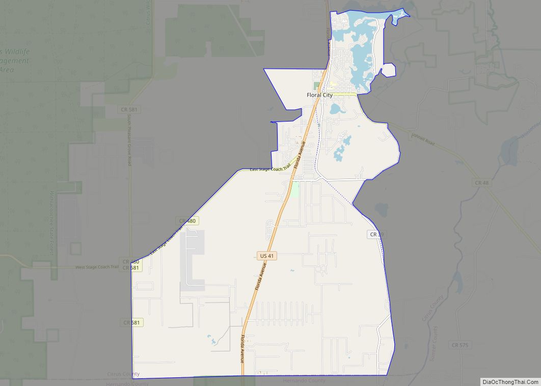
Floral City is a census-designated place (CDP) in Citrus County, Florida, United States. The population was 5,216 at the 2010 census. The community is home to the Floral City Heritage Hall Museum and hosts the Floral City Heritage Days the first weekend in December. The area has a history of phosphate mining and includes historic … Read more

Map of Fleming Island CDP

Map of Fleming Island CDP

Fleming Island is an unincorporated community and census-designated place (CDP) in Clay County, Florida, United States. It is located 21 miles (34 km) southwest of downtown Jacksonville, on the western side of the St. Johns River, off US 17. As of the 2010 census the Fleming Island CDP had a population of 27,126. Fleming Island’s ZIP … Read more

Map of Flagler Estates CDP

Map of Flagler Estates CDP

Flagler Estates is an unincorporated community in Flagler and St. Johns counties in the U.S. state of Florida. It is located 8 mi (13 km) southeast of Hastings. The Flagler County portion of Flagler Estates is part of the Deltona–Daytona Beach–Ormond Beach, FL metropolitan statistical area, while the St. Johns County portion is part of the Jacksonville … Read more

Map of Floridatown CDP

Map of Floridatown CDP

Floridatown is a census-designated place located in Santa Rosa County, Florida. It is now considered to be a neighborhood within Pace. The population was 244 as of the 2010 census. Floridatown CDP overview: Name: Floridatown CDP LSAD Code: 57 LSAD Description: CDP (suffix) State: Florida County: Santa Rosa County Elevation: 13 ft (4 m) Total Area: 0.403 sq mi … Read more

Map of Florida Ridge CDP

Map of Florida Ridge CDP

Florida Ridge is a census-designated place (CDP) in Indian River County, Florida, United States. The population was 18,164 at the 2010 census. Florida Ridge is part of the Sebastian–Vero Beach Metropolitan Statistical Area. Florida Ridge CDP overview: Name: Florida Ridge CDP LSAD Code: 57 LSAD Description: CDP (suffix) State: Florida County: Indian River County Elevation: … Read more

Map of Florida City city

Map of Florida City

Florida City is a city in Miami-Dade County, Florida, United States. It is the southernmost municipality in the South Florida metropolitan area. Florida City is primarily a Miami suburb and a major agricultural area. As of the 2020 census, it had a population of 13,085, up from 11,245 in 2010. The city lies to the … Read more

Map of Fort Green Springs CDP

Map of Fort Green Springs CDP

Fort Green Springs is an unincorporated community and census-designated place (CDP) in Hardee County, Florida, United States. Its population was 190 as of the 2020 census. Fort Green Springs CDP overview: Name: Fort Green Springs CDP LSAD Code: 57 LSAD Description: CDP (suffix) State: Florida County: Hardee County Elevation: 115 ft (35 m) Total Area: 10.37 sq mi (26.85 km²) … Read more

Map of Fort Denaud CDP

Map of Fort Denaud CDP

Fort Denaud is a census-designated place (CDP) and former fort in Hendry County, Florida, United States. As of the 2020 census,the population of the CDP was 2,049. Fort Denaud CDP overview: Name: Fort Denaud CDP LSAD Code: 57 LSAD Description: CDP (suffix) State: Florida County: Hendry County Elevation: 14 ft (4 m) Total Area: 20.76 sq mi (53.78 km²) Land … Read more

Map of Forest City CDP

Map of Forest City CDP, Florida

Forest City is a census-designated place and an area in Seminole County, Florida, United States. Its historic center is now in the City of Altamonte Springs. Data in this article deals only with the unincorporated section. The population was 12,612 at the 2000 census. It is part of the Orlando–Kissimmee Metropolitan Statistical Area. Forest City … Read more

Map of Fort Myers Beach town

Map of Fort Myers Beach town

Fort Myers Beach is a town located on the North end of Estero Island in Lee County, Florida, United States. The town is on the Gulf of Mexico and is accessed from the mainland by a bridge over Estero Bay. The population was 5,582 at the 2020 census. It is part of the Cape Coral-Fort … Read more

Map of Fort Meade city

Map of Fort Meade city, Florida

Fort Meade is a city in Polk County, Florida, United States. As of 2018, the population recorded by the U.S. Census Bureau is 6,203. It is part of the Lakeland–Winter Haven Metropolitan Statistical Area. The city was named for George Meade, at the time an Army lieutenant serving in Florida following the Second Seminole War. … Read more

Map of Fort Green CDP

Map of Fort Green CDP

Fort Green is an unincorporated community and census-designated place (CDP) in Hardee County, Florida, United States. Its population was 78 as of the 2020 census. Fort Green CDP overview: Name: Fort Green CDP LSAD Code: 57 LSAD Description: CDP (suffix) State: Florida County: Hardee County Elevation: 115 ft (35 m) Total Area: 4.04 sq mi (10.47 km²) Land Area: 4.04 sq mi … Read more