Map of Lakeside CDP, Florida

Map of Lakeside CDP, Florida

Lakeside is an unincorporated area and census-designated place in Clay County, Florida, United States. The population was 30,943 at the 2010 census. It is part of the greater Orange Park area. Lakeside CDP overview: Name: Lakeside CDP LSAD Code: 57 LSAD Description: CDP (suffix) State: Florida County: Clay County Elevation: 66 ft (20 m) Total Area: 15.65 sq mi … Read more

Map of Lakeland Highlands CDP

Map of Lakeland Highlands CDP

Lakeland Highlands is an unincorporated community and census-designated place (CDP) in Polk County, Florida, United States. The population was 11,056 at the 2010 census. It is part of the Lakeland–Winter Haven Metropolitan Statistical Area. It is an affluent residential community located south of the Lakeland city limits, and north of the Mulberry city limits. Lakeland … Read more

Map of Lake Worth city

Map of Lake Worth city, Florida

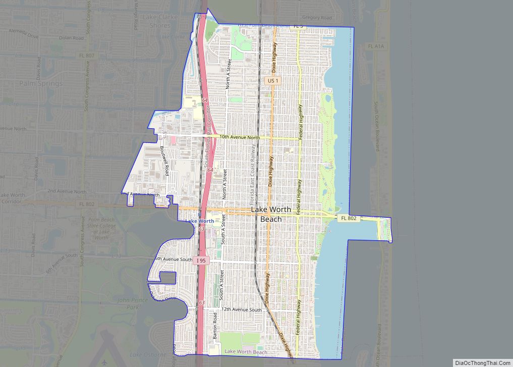
Lake Worth city overview: Name: Lake Worth city LSAD Code: 25 LSAD Description: city (suffix) State: Florida County: Palm Beach County FIPS code: 1239075 Online Interactive Map Lake Worth online map. Source: Basemap layers from Google Map, Open Street Map (OSM), Arcgisonline, Wmflabs. Boundary Data from Database of Global Administrative Areas. Lake Worth location map. … Read more

Map of Land O' Lakes CDP

Map of Land O’ Lakes CDP

Land o’ Lakes is a census-designated place (CDP) in Pasco County, Florida, United States. Land o’ Lakes is part of the Tampa-St. Petersburg-Clearwater, Florida MSA. As of the 2010 census, the CDP population was 31,145. The CDP grew rapidly during the 1990s, growing from 7,800 residents to 20,971 as new housing developments were built. Average … Read more

Map of Lamont CDP, Florida

Map of Lamont CDP, Florida

Lamont is an unincorporated community and census-designated place (CDP) in Jefferson County, Florida, United States. As of the 2020 census,the population was 170. Lamont CDP overview: Name: Lamont CDP LSAD Code: 57 LSAD Description: CDP (suffix) State: Florida County: Jefferson County Elevation: 66 ft (20 m) Total Area: 2.35 sq mi (6.08 km²) Land Area: 2.35 sq mi (6.08 km²) Water Area: 0.00 sq mi … Read more

Map of Lakewood Park CDP

Map of Lakewood Park CDP, Florida

Lakewood Park is a Census-designated place in St. Lucie County, Florida, United States. The population was 11,323 at the 2010 census. It is part of the Port St. Lucie Metropolitan Statistical Area. Lakewood Park CDP overview: Name: Lakewood Park CDP LSAD Code: 57 LSAD Description: CDP (suffix) State: Florida County: St. Lucie County Elevation: 20 ft … Read more

Map of Lauderdale-by-the-Sea town

Map of Lauderdale-by-the-Sea town

Lauderdale-by-the-Sea is a town in Broward County, Florida, United States, situated 33 miles north of Miami. As of the 2020 census, the population was 6,198. It is part of the Miami–Fort Lauderdale–West Palm Beach Metropolitan Statistical Area, which was home to 5,564,635 people at the 2010 census. Lauderdale-by-the-Sea town overview: Name: Lauderdale-by-the-Sea town LSAD Code: … Read more

Map of Largo city

Map of Largo city, Florida

Largo is the third largest city in Pinellas County, Florida, United States, as well as the fourth largest in the Tampa Bay area. As of the 2020 Census, the city had a population of 82,500, up from 69,371 in 2000. Largo was first incorporated in 1905. In 1913, it became the first municipality in Pinellas … Read more

Map of Lantana town

Map of Lantana town, Florida

Lantana is a town in Palm Beach County, Florida, United States. It is 37 miles north from Fort Lauderdale. This town is part of the Miami metropolitan area. The population was 10,423 at the 2010 United States Census. Lantana town overview: Name: Lantana town LSAD Code: 43 LSAD Description: town (suffix) State: Florida County: Palm … Read more

Map of Laurel Hill city

Map of Laurel Hill city, Florida

Laurel Hill is a city in Okaloosa County, Florida, United States. The population was 537 at the 2010 census. It is part of the Fort Walton Beach–Crestview–Destin Metropolitan Statistical Area. Laurel Hill city overview: Name: Laurel Hill city LSAD Code: 25 LSAD Description: city (suffix) State: Florida County: Okaloosa County Elevation: 282 ft (86 m) Total Area: … Read more

Map of Lauderhill city

Map of Lauderhill city

Lauderhill, officially the City of Lauderhill, is a city in Broward County, Florida, United States. As of the 2020 census, the city’s population was 74,482. It is a principal city of the Miami metropolitan area, which was home to an estimated 6,012,331 people in 2015. Lauderhill city overview: Name: Lauderhill city LSAD Code: 25 LSAD … Read more

Map of Lauderdale Lakes city

Map of Lauderdale Lakes city, Florida

Lauderdale Lakes, officially the City of Lauderdale Lakes, is a city in Broward County, Florida, United States. As of the 2020 United States Census, the city’s population was 35,954. It is part of the Miami–Fort Lauderdale–West Palm Beach Metropolitan Statistical Area, which is home to 5,564,635 people. Lauderdale Lakes city overview: Name: Lauderdale Lakes city … Read more