Map of Pretty Bayou CDP

Map of Pretty Bayou CDP

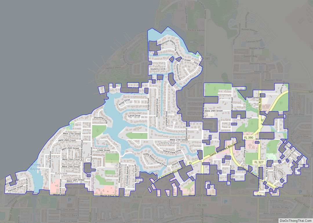
Pretty Bayou is a census-designated place (CDP) in Bay County, Florida, United States. The population was 3,206 at the 2010 census. It is part of the Panama City–Lynn Haven–Panama City Beach Metropolitan Statistical Area. In 2018, Hurricane Michael caused significant damage to the city. Pretty Bayou CDP overview: Name: Pretty Bayou CDP LSAD Code: 57 … Read more

Map of Port St. John CDP

Map of Port St. John CDP

Port St. John is a census-designated place located between Titusville and Cocoa in Brevard County, Florida. The population was 12,267 at the 2010 United States Census. It is part of the Palm Bay–Melbourne–Titusville Metropolitan Statistical Area. Port St. John CDP overview: Name: Port St. John CDP LSAD Code: 57 LSAD Description: CDP (suffix) State: Florida … Read more

Map of Port St. Joe city

Map of Port St. Joe city

Port St. Joe is a city and the county seat of Gulf County, Florida. It is located at the intersection of U.S. Highway 98 and State Road 71 As of the 2020 census,the population was 3,357, a decline from 3,644 as of the 2000 census. Port St. Joe city overview: Name: Port St. Joe city … Read more

Map of Punta Gorda city

Map of Punta Gorda city

Punta Gorda (/ˌpʌntə ˈɡɔːrdə/; English: Fat Point) is a city located in Southwest Florida and is the county seat of Charlotte County, Florida, United States. As of the 2020 U.S. Census the city had a population of 19,471. Punta Gorda is part of the Sarasota-Bradenton-Punta Gorda Combined Statistical Area. Punta Gorda was the scene of … Read more

Map of Progress Village CDP

Map of Progress Village CDP

Progress Village is a census-designated place (CDP) in Hillsborough County, Florida, United States. Per the 2020 census, the population was 11,188. Progress Village CDP overview: Name: Progress Village CDP LSAD Code: 57 LSAD Description: CDP (suffix) State: Florida County: Hillsborough County Elevation: 16 ft (5 m) Total Area: 3.25 sq mi (8.42 km²) Land Area: 3.03 sq mi (7.84 km²) Water Area: 0.22 sq mi … Read more

Map of Princeton CDP, Florida

Map of Princeton CDP, Florida

Princeton is a census-designated place (CDP) and unincorporated community in Miami-Dade County, Florida, United States. The population was 39,208 at the 2020 census, up from 22,038 at the 2010 census. Princeton CDP overview: Name: Princeton CDP LSAD Code: 57 LSAD Description: CDP (suffix) State: Florida County: Miami-Dade County Elevation: 10 ft (3 m) Total Area: 7.47 sq mi (19.34 km²) … Read more

Map of Quincy city, Florida

Map of Quincy city, Florida

Quincy is a city in and the county seat of Gadsden County, Florida, United States. The population was 7,970 as of the 2020 census. Quincy is part of the Tallahassee metropolitan area. Quincy city overview: Name: Quincy city LSAD Code: 25 LSAD Description: city (suffix) State: Florida County: Gadsden County Elevation: 207 ft (63 m) Total Area: … Read more

Map of Quail Ridge CDP

Map of Quail Ridge CDP

Quail Ridge is an unincorporated community and census-designated place in Pasco County, Florida, United States. Its population was 1,040 as of the 2010 census. Quail Ridge CDP overview: Name: Quail Ridge CDP LSAD Code: 57 LSAD Description: CDP (suffix) State: Florida County: Pasco County Elevation: 56 ft (17 m) Total Area: 4.639 sq mi (12.01 km²) Land Area: 4.156 sq mi (10.76 km²) … Read more

Map of Punta Rassa CDP

Map of Punta Rassa CDP

Punta Rassa is an unincorporated community and census-designated place (CDP) in Lee County, Florida, United States. The population was 1,620 at the 2020 census. It is part of the Cape Coral-Fort Myers, Florida Metropolitan Statistical Area. Punta Rassa CDP overview: Name: Punta Rassa CDP LSAD Code: 57 LSAD Description: CDP (suffix) State: Florida County: Lee … Read more

Map of Reddick town

Map of Reddick town, Florida

Reddick is a town in Marion County, Florida, United States. As of the 2020 census, the town population was 449, down from 506 in 2010. It is part of the Ocala Metropolitan Statistical Area. Reddick town overview: Name: Reddick town LSAD Code: 43 LSAD Description: town (suffix) State: Florida County: Marion County Elevation: 72 ft (22 m) … Read more

Map of Raleigh city

Map of Raleigh CDP, Florida

Raleigh is a census-designated place (CDP) in Levy County, Florida, United States. The population was 373 at the 2010 census. Raleigh CDP overview: Name: Raleigh CDP LSAD Code: 57 LSAD Description: CDP (suffix) State: Florida County: Levy County Elevation: 74 ft (23 m) Total Area: 1.94 sq mi (5.03 km²) Land Area: 1.94 sq mi (5.03 km²) Water Area: 0.00 sq mi (0.00 km²) Total Population: … Read more

Map of Raiford town

Map of Raiford town

Raiford is a town in Union County, Florida, United States. The population was 255 at the 2010 census. As of 2018, the population recorded by the U.S. Census Bureau is 236. It was home to the original Florida State Prison and continues to be home to a total of 3 prisons. Raiford town overview: Name: … Read more