Map of Adel city

Map of Adel city, Georgia

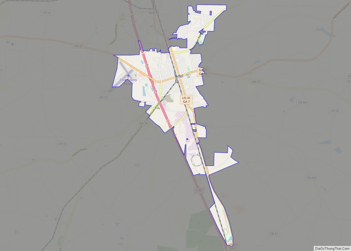
The city of Adel /ˈeɪdɛl/ is the county seat of Cook County, Georgia, United States, located fifty-two miles (84 km) southeast of Albany. As of the 2020 census, the city had a population of 5,571. Adel city overview: Name: Adel city LSAD Code: 25 LSAD Description: city (suffix) State: Georgia County: Cook County Elevation: 240 ft (73 m) … Read more

Map of Albany city, Georgia

Map of Albany city, Georgia

Albany (/ˈɔːlbəni/ AWL-bə-nee) is a city in the U.S. state of Georgia. Located on the Flint River, it is the seat of Dougherty County, and is the sole incorporated city in that county. Located in southwest Georgia, it is the principal city of the Albany, Georgia metropolitan area. The population was 77,434 at the 2010 … Read more

Map of Alapaha town

Map of Alapaha town

Alapaha is a town in Berrien County, Georgia, United States, along the Alapaha River. As of the 2020 census, the city had a population of 481. Alapaha developed from a trade settlement on the site of a Seminole village with the same name. The present-day Georgia town of Lakeland was originally named “Alapaha” and existed … Read more

Map of Alamo town, Georgia

Map of Alamo town, Georgia

Alamo is a city in Wheeler County, Georgia, United States. As of the 2020 census, the city had a population of 771. The city is the county seat of Wheeler County. Alamo town overview: Name: Alamo town LSAD Code: 43 LSAD Description: town (suffix) State: Georgia County: Wheeler County Elevation: 230 ft (70 m) Total Area: 2.01 sq mi … Read more

Map of Allentown city, Georgia

Map of Allentown city, Georgia

Allentown is a city in Bleckley, Laurens, Twiggs, and Wilkinson counties in the U.S. state of Georgia, primarily in Wilkinson County. As of the 2010 census, the city had a population of 169, down from 287 at the 2000 census. The Twiggs County portion is part of the Macon Metropolitan Statistical Area, while the Laurens … Read more

Map of Allenhurst city

Map of Allenhurst city, Georgia

Allenhurst is a city in Liberty County, Georgia, United States. It is a part of the Hinesville-Fort Stewart metropolitan statistical area. As of the 2020 census, the city had a population of 816. Allenhurst city overview: Name: Allenhurst city LSAD Code: 25 LSAD Description: city (suffix) State: Georgia County: Liberty County Elevation: 59 ft (18 m) Total … Read more

Map of Aldora town

Map of Aldora town

Aldora is a town in Lamar County, Georgia, United States. As of the 2020 census, the city had a recorded population of 0, due to a “0 percent self-response rate” to the 2020 census. The actual population was estimated at 103. Aldora town overview: Name: Aldora town LSAD Code: 43 LSAD Description: town (suffix) State: … Read more

Map of Alston town

Map of Alston town

Alston is a town in Montgomery County, Georgia, United States, with a population of 178 at the 2020 census. It is part of the Vidalia Micropolitan Statistical Area. Alston town overview: Name: Alston town LSAD Code: 43 LSAD Description: town (suffix) State: Georgia County: Montgomery County Elevation: 230 ft (70 m) Total Area: 2.87 sq mi (7.44 km²) Land Area: … Read more

Map of Alpharetta city

Map of Alpharetta city

Alpharetta is a city in northern Fulton County, Georgia, United States, and is a part of the Atlanta metropolitan area. As of the 2020 US Census, Alpharetta’s population was 65,818; in 2010, the population was 57,551. Alpharetta city overview: Name: Alpharetta city LSAD Code: 25 LSAD Description: city (suffix) State: Georgia County: Fulton County Incorporated: … Read more

Map of Alma city, Georgia

Map of Alma city, Georgia

Alma is a city in Bacon County, Georgia, United States, and the county seat. As of the 2020 census, the city had a population of 3,433. Alma is known as Georgia’s blueberry capital, and hosts a Blueberry Festival each June. Alma city overview: Name: Alma city LSAD Code: 25 LSAD Description: city (suffix) State: Georgia … Read more

Map of Americus city

Map of Americus city, Georgia

Americus is the county seat of Sumter County, Georgia, United States. As of the 2020 census, the city had a population of 16,230. It is the principal city of the Americus Micropolitan Statistical Area, a micropolitan area that covers Schley and Sumter counties and had a combined population of 36,966 at the 2000 census. Americus … Read more

Map of Ambrose city

Map of Ambrose city, Georgia

Ambrose is a city in Coffee County, Georgia, United States. As of the 2020 census, the city had a population of 327. Ambrose city overview: Name: Ambrose city LSAD Code: 25 LSAD Description: city (suffix) State: Georgia County: Coffee County Elevation: 308 ft (94 m) Total Area: 3.13 sq mi (8.12 km²) Land Area: 3.05 sq mi (7.90 km²) Water Area: 0.08 sq mi (0.22 km²) … Read more