Map of Post Falls city

Map of Post Falls city

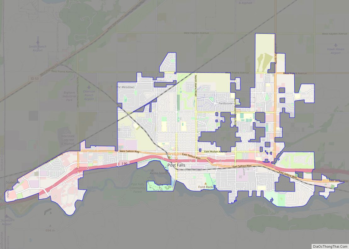
Post Falls is a city in Kootenai County, Idaho, between Coeur d’Alene and Spokane, Washington. It is a suburb of Coeur d’Alene, to the east, and a bedroom community to Spokane, to the west. The population was 38,485 at the time of the 2020 census, up from 17,247 in the 2000 census, making it Idaho’s … Read more

Map of Ponderay city

Map of Ponderay city

Ponderay (/ˌpɒndəˈreɪ/ POND-ə-RAY) is a city in Bonner County, Idaho. The population was 1,137 at the 2010 census, up from 638 in 2000. Ponderay’s city motto is “Little City with the Big Future”. Its name is an English phonetic spelling of the French words “Pend Oreille”, the name of the lake the city sits upon. … Read more

Map of Pocatello city

Map of Pocatello city

Pocatello (/ˈpoʊkəˈtɛloʊ/ (listen)) is the county seat and largest city of Bannock County, with a small portion on the Fort Hall Indian Reservation in neighboring Power County, in the southeastern part of the U.S. state of Idaho. It is the principal city of the Pocatello metropolitan area, which encompasses all of Bannock County. As of … Read more

Map of Rexburg city

Map of Rexburg city

Rexburg is a city in Madison County, Idaho, United States. The population was 39,409 at the 2020 census. The city is the county seat of Madison County and its largest city. Rexburg is the principal city of the Rexburg, ID Micropolitan Statistical Area, which includes Fremont and Madison Counties. The city is home to Brigham … Read more

Map of Reubens city

Map of Reubens city

Reubens is a city in Lewis County, Idaho, United States, on the Camas Prairie. The population was 71 at the 2010 census, and 72 in 2000. Reubens city overview: Name: Reubens city LSAD Code: 25 LSAD Description: city (suffix) State: Idaho County: Lewis County Elevation: 3,527 ft (1,075 m) Total Area: 0.17 sq mi (0.44 km²) Land Area: 0.17 sq mi (0.44 km²) … Read more

Map of Rathdrum city

Map of Rathdrum city

Rathdrum is a city in Kootenai County, Idaho, United States. The population was 6,826 at the 2010 census, up from 4,816 in 2000. It is part of the Coeur d’Alene Metropolitan Statistical Area, which includes the entire county. It is named after Rathdrum in Ireland. Rathdrum city overview: Name: Rathdrum city LSAD Code: 25 LSAD … Read more

Map of Princeton CDP, Idaho

Map of Princeton CDP, Idaho

Princeton is a census-designated place in Latah County, Idaho, United States. Princeton CDP overview: Name: Princeton CDP LSAD Code: 57 LSAD Description: CDP (suffix) State: Idaho County: Latah County Elevation: 2,516 ft (767 m) Total Area: 0.640 sq mi (1.66 km²) Land Area: 0.637 sq mi (1.65 km²) Water Area: 0.003 sq mi (0.008 km²) Total Population: 148 Population Density: 230/sq mi (89/km²) ZIP code: 83857 Area … Read more

Map of Priest River city

Map of Priest River city

Priest River is a city in Bonner County, Idaho. The population was 1,751 at the 2010 census. Located in the Idaho Panhandle region of the state, the city is at the mouth of the Priest River on the Pend Oreille River. Priest River city overview: Name: Priest River city LSAD Code: 25 LSAD Description: city … Read more

Map of Riverside CDP, Idaho

Map of Riverside CDP, Idaho

Riverside is a census-designated place in Bingham County, Idaho, United States. Its population was 838 as of the 2010 census. Riverside CDP overview: Name: Riverside CDP LSAD Code: 57 LSAD Description: CDP (suffix) State: Idaho County: Bingham County Elevation: 4,459 ft (1,359 m) Total Area: 2.145 sq mi (5.56 km²) Land Area: 2.145 sq mi (5.56 km²) Water Area: 0 sq mi (0 km²) Total Population: … Read more

Map of Ririe city

Map of Ririe city

Ririe is a city in Bonneville and Jefferson counties in the eastern part of the U.S. state of Idaho. It is part of the Idaho Falls metropolitan area. The population was 656 at the time of the 2010 census. Ririe city overview: Name: Ririe city LSAD Code: 25 LSAD Description: city (suffix) State: Idaho County: … Read more

Map of Riggins city

Map of Riggins city

Riggins is a city in the western United States in Idaho County, Idaho. Nestled deep in a canyon at the confluence of the Salmon and Little Salmon rivers in west central Idaho, it is approximately 150 highway miles (240 km) north of Boise, and 120 highway miles (190 km) south-southeast of Lewiston. The elevation is 1,821 feet … Read more

Map of Rigby city

Map of Rigby city

Rigby is a city in and the county seat of Jefferson County, Idaho, United States. The population was 3,945 at the 2010 census, up from 2,998 in 2000. Rigby city overview: Name: Rigby city LSAD Code: 25 LSAD Description: city (suffix) State: Idaho County: Jefferson County Elevation: 4,856 ft (1,480 m) Total Area: 2.37 sq mi (6.13 km²) Land Area: … Read more