Map of Payne Gap CDP

Map of Payne Gap CDP

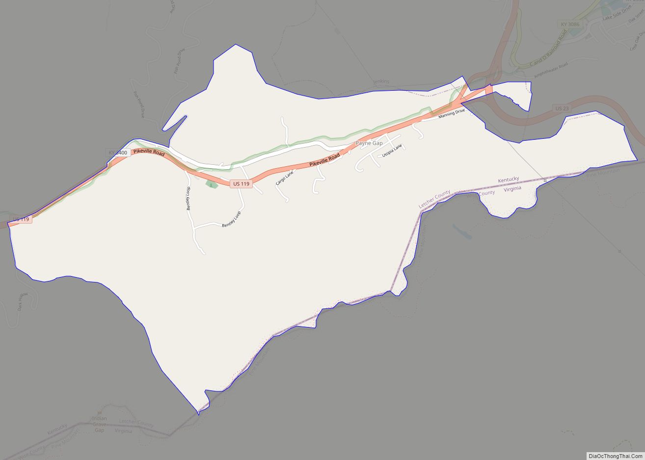
Payne Gap is an unincorporated community and census-designated place in Letcher County, Kentucky, United States. Its population was 329 as of the 2010 census. U.S. Route 119 passes through the community. Payne Gap CDP overview: Name: Payne Gap CDP LSAD Code: 57 LSAD Description: CDP (suffix) State: Kentucky County: Letcher County Elevation: 1,762 ft (537 m) Total … Read more

Map of Phelps CDP

Map of Phelps CDP, Kentucky

Phelps is a census-designated place (CDP) in Pike County, Kentucky, United States. The population was 1,053 at the 2000 census. It is the easternmost census-designated community in Kentucky. Phelps CDP overview: Name: Phelps CDP LSAD Code: 57 LSAD Description: CDP (suffix) State: Kentucky County: Pike County Elevation: 837 ft (255 m) Total Area: 7.99 sq mi (20.70 km²) Land Area: … Read more

Map of Pewee Valley city

Map of Pewee Valley city

Pewee Valley is a home rule-class city in Oldham County, Kentucky, United States. The population was 1,456 at the 2010 census. Pewee Valley city overview: Name: Pewee Valley city LSAD Code: 25 LSAD Description: city (suffix) State: Kentucky County: Oldham County Incorporated: 1870 Elevation: 781 ft (238 m) Total Area: 1.94 sq mi (5.03 km²) Land Area: 1.93 sq mi (5.00 km²) Water … Read more

Map of Petersburg CDP, Kentucky

Map of Petersburg CDP, Kentucky

Petersburg is a rural unincorporated community and census-designated place (CDP) in Boone County, Kentucky, United States. As of the 2010 census Petersburg, along with its surrounding areas that use the 41080 zip code, had a population of 620. It is located 25 miles away from Cincinnati, Ohio. Archaeological evidence reveals an ancient Indian settlement was … Read more

Map of Pineville city, Kentucky

Map of Pineville city, Kentucky

Pineville (locally /ˈpaɪnvəl, -vɪl/) is a home rule-class city in Bell County, Kentucky, United States. It is the seat of its county. The population was 1,732 as of the 2010 census. It is located on a small strip of land between the Cumberland River and Pine Mountain. Pineville city overview: Name: Pineville city LSAD Code: … Read more

Map of Pine Knot CDP

Map of Pine Knot CDP

Pine Knot is an unincorporated community and census-designated place (CDP) in McCreary County, Kentucky, United States. The population was 1,380 at the 2020 census, down from 1,621 in 2010. Pine Knot CDP overview: Name: Pine Knot CDP LSAD Code: 57 LSAD Description: CDP (suffix) State: Kentucky County: McCreary County Elevation: 1,421 ft (433 m) Total Area: 6.47 sq mi … Read more

Map of Pikeville city

Map of Pikeville city, Kentucky

Pikeville (/ˈpaɪkvəl/) is a city in and the county seat of Pike County, Kentucky, United States. During the 2020 U.S. Census, the population within Pikeville’s city limits was 7,754. In Kentucky’s current city classification system, Pikeville is a home rule-class city, a category that includes all of the state’s more than 400 cities except for … Read more

Map of Plano CDP, Kentucky

Map of Plano CDP, Kentucky

Plano is a CDP in Warren County, Kentucky, United States. The population at the 2020 census was 1,223. The elevation is 610 feet. Plano CDP overview: Name: Plano CDP LSAD Code: 57 LSAD Description: CDP (suffix) State: Kentucky County: Warren County Total Area: 1.03 sq mi (2.67 km²) Land Area: 1.03 sq mi (2.67 km²) Water Area: 0.00 sq mi (0.00 km²) Total Population: … Read more

Map of Pippa Passes city

Map of Pippa Passes city

Pippa Passes is a home rule-class city located along Caney Fork in Knott County, eastern Kentucky, United States. Its formal name was chosen to honor benefactors of Alice Lloyd College. Residents commonly call the community “Caney” or “Caney Creek”. The population was 533 at the 2010 census, up from 297 at the 2000 census. The … Read more

Map of Pioneer Village city

Map of Pioneer Village city

Pioneer Village is a home rule-class city in Bullitt County, Kentucky, in the United States. The population was 2,030 at the time of the 2010 census. Pioneer Village was struck by a tornado in 1996. Pioneer Village city overview: Name: Pioneer Village city LSAD Code: 25 LSAD Description: city (suffix) State: Kentucky County: Bullitt County … Read more

Map of Pleasureville city

Map of Pleasureville city

Pleasureville is a home rule-class city in Henry and Shelby counties, Kentucky, United States. The population was 834 at the time of the 2010 U.S. Census. Pleasureville city overview: Name: Pleasureville city LSAD Code: 25 LSAD Description: city (suffix) State: Kentucky County: Henry County, Shelby County Incorporated: 1842 Elevation: 892 ft (272 m) Total Area: 0.49 sq mi (1.26 km²) … Read more

Map of Pleasant View CDP

Map of Pleasant View CDP, Kentucky

Pleasant View is a census-designated place, unincorporated community and coal town in Whitley County, Kentucky, United States. Their post office closed in 1965. Pleasant View CDP overview: Name: Pleasant View CDP LSAD Code: 57 LSAD Description: CDP (suffix) State: Kentucky County: Whitley County Elevation: 997 ft (304 m) Total Area: 0.82 sq mi (2.13 km²) Land Area: 0.79 sq mi (2.05 km²) Water … Read more