Map of Plantation city, Kentucky

Map of Plantation city, Kentucky

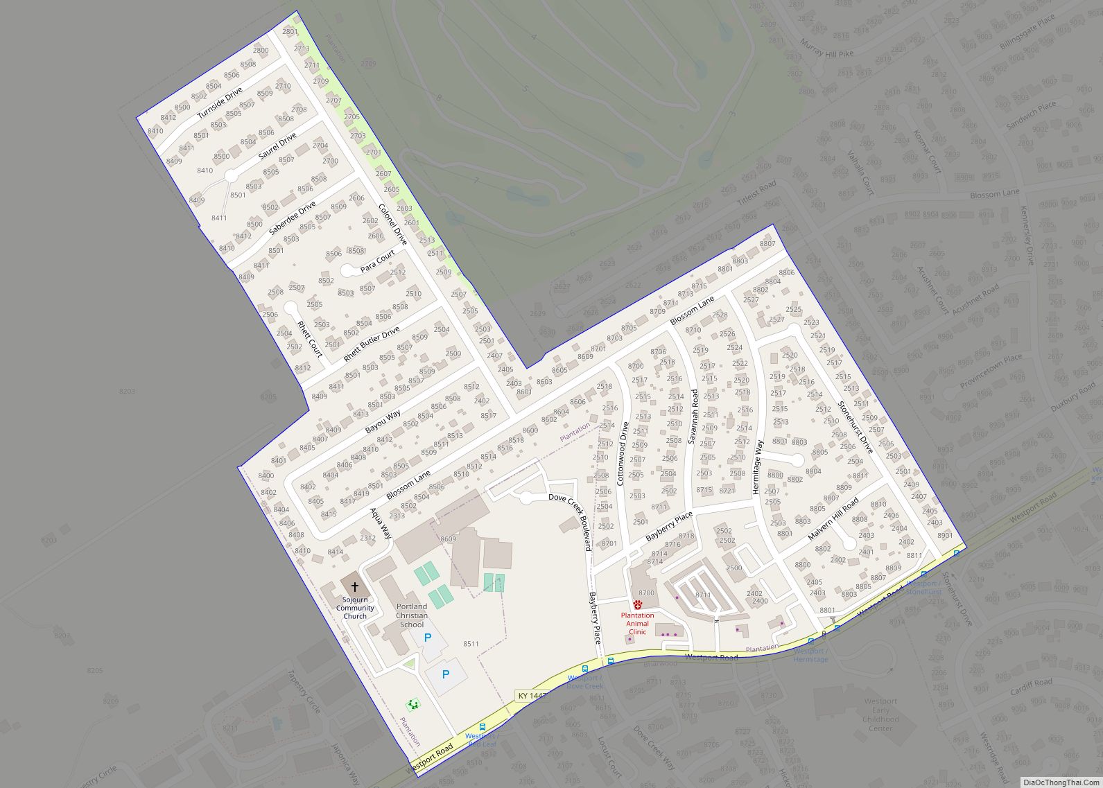
Plantation is a home rule-class city in Jefferson County, Kentucky, United States, and a part of the Louisville Metro government. The population was 832 at the 2010 census, down from 902 at the 2000 census. Plantation city overview: Name: Plantation city LSAD Code: 25 LSAD Description: city (suffix) State: Kentucky County: Jefferson County Incorporated: 1960 … Read more

Map of Poplar Hills city

Map of Poplar Hills city

Poplar Hills is a home rule-class city in Jefferson County, Kentucky, United States. It is a part of the Louisville Metro government, but operates as a city under the Mayor to Commissioner form of government. Per the 2020 census, the population was 380, but the city administration has made several annexation ordinances that have passed … Read more

Map of Poole CDP

Map of Poole CDP, Kentucky

Poole is an unincorporated community and census-designated place (CDP) in Webster and Henderson counties, Kentucky, United States. The community is on U.S. Route 41A, 15 miles (24 km) south of Henderson and 20 miles (32 km) north of Providence. The center of Poole is in northern Webster County, and the community extends north into southern Henderson County. … Read more

Map of Plum Springs city

Map of Plum Springs city

Plum Springs is a home rule-class city in Warren County, Kentucky, in the United States. The population was 453 at the time of the year 2010 U.S. Census. It is included in the Bowling Green metropolitan area. It is named for its location on Plum Springs Road (Ky. 957). Plum Springs city overview: Name: Plum … Read more

Map of Prestonville city

Map of Prestonville city

Prestonville is a home rule-class city located at the confluence of the Ohio and Kentucky rivers in Carroll County, Kentucky, in the United States. It lies across the Kentucky River from Carrollton. The population was 161 at the 2010 U.S. Census. Prestonville city overview: Name: Prestonville city LSAD Code: 25 LSAD Description: city (suffix) State: … Read more

Map of Prestonsburg city

Map of Prestonsburg city

Prestonsburg is a small home rule-class city in and the county seat of Floyd County, Kentucky, United States. It is in the eastern part of the state in the valley of the Big Sandy River. The population was 3,255 at the time of the 2010 census, down from 3,612 at the 2000 census. Prestonsburg city … Read more

Map of Powderly city

Map of Powderly city, Kentucky

Powderly is a home rule-class city in Muhlenberg County, Kentucky, in the United States. The population was 745 at the 2010 census. Powderly city overview: Name: Powderly city LSAD Code: 25 LSAD Description: city (suffix) State: Kentucky County: Muhlenberg County Incorporated: 1963 Elevation: 449 ft (137 m) Total Area: 1.60 sq mi (4.15 km²) Land Area: 1.56 sq mi (4.05 km²) Water Area: … Read more

Map of Providence city, Kentucky

Map of Providence city, Kentucky

Providence is a home rule-class city in Webster County, Kentucky, in the United States. The population was 3,193 at the time of the 2010 United States Census, making the most populous community in the county. Providence city overview: Name: Providence city LSAD Code: 25 LSAD Description: city (suffix) State: Kentucky County: Webster County Incorporated: 1860 … Read more

Map of Prospect city

Map of Prospect city, Kentucky

Prospect is a home rule-class city in Jefferson and Oldham counties in the U.S. state of Kentucky. The Jefferson County portion is a part of the Louisville Metro government. The population was 4,698 at the time 2010 census. It is one of the wealthiest communities in Kentucky. Prospect city overview: Name: Prospect city LSAD Code: … Read more

Map of Princeton city, Kentucky

Map of Princeton city, Kentucky

Princeton is a home rule-class city in Caldwell County, Kentucky, in the United States. It is the seat of its county. The population was 6,329 during the 2010 U.S. Census. Princeton is home to several notable attractions such as Adsmore Museum, Champion-Shepherdson House (home of the Princeton Art Guild), University of Kentucky Research and Education … Read more

Map of Raceland city

Map of Raceland city, Kentucky

Raceland is a home rule-class city in Greenup County, Kentucky, United States, in the Ohio River valley. As of the 2010 census, the population was 2,424. It is part of the Huntington–Ashland metropolitan area. Raceland city overview: Name: Raceland city LSAD Code: 25 LSAD Description: city (suffix) State: Kentucky County: Greenup County Elevation: 545 ft (166 m) … Read more

Map of Rabbit Hash CDP

Map of Rabbit Hash CDP

Rabbit Hash is an unincorporated community and census-designated place (CDP) in Boone County, Kentucky, United States, with a population of 315 (2010 census). It is listed on the National Register of Historic Places. The town is notable for its name, its string of canine mayors, and its historic general store (c. 1831) which was largely … Read more