Map of Glen Burnie CDP

Map of Glen Burnie CDP

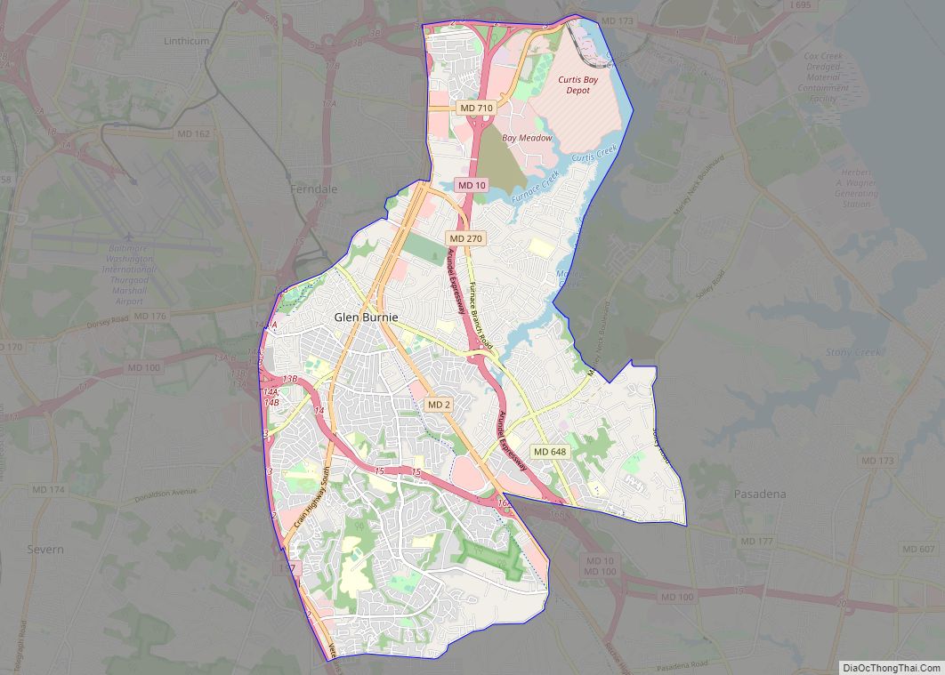
Glen Burnie is an unincorporated town and census-designated place (CDP) in Anne Arundel County, Maryland, United States. It is a suburb of Baltimore. The population was 72,891 at the 2020 census. Glen Burnie CDP overview: Name: Glen Burnie CDP LSAD Code: 57 LSAD Description: CDP (suffix) State: Maryland County: Anne Arundel County Founded: 1812 Elevation: … Read more

Map of Glassmanor CDP

Map of Glassmanor CDP

Glassmanor is an unincorporated community and census-designated place in Prince George’s County, Maryland, United States. As of the 2020 census, it had a population of 18,430. In the 1990 and 2000 censuses, the United States Census Bureau had placed Glassmanor and the adjacent community of Oxon Hill in the “Oxon Hill-Glassmanor” census-designated place for statistical … Read more

Map of Girdletree CDP

Map of Girdletree CDP

Girdletree is a census-designated place in Worcester County, Maryland, United States. The population was 149 at the 2010 census. It is part of the Salisbury, Maryland-Delaware Metropolitan Statistical Area. Girdletree CDP overview: Name: Girdletree CDP LSAD Code: 57 LSAD Description: CDP (suffix) State: Maryland County: Worcester County Elevation: 36 ft (11 m) Total Area: 0.68 sq mi (1.77 km²) Land … Read more

Map of Glenmont CDP

Map of Glenmont CDP, Maryland

Glenmont is an unincorporated community and census-designated place in Montgomery County, Maryland, United States. The United States Census Bureau had combined Glenmont with nearby Wheaton to create the census-designated place of Wheaton-Glenmont, from 2000 to 2010. It had a population of 16,710 in 2020. Glenmont CDP overview: Name: Glenmont CDP LSAD Code: 57 LSAD Description: … Read more

Map of Glenarden city

Map of Glenarden city

Glenarden is a city in Prince George’s County, Maryland, United States. Per the 2020 census, the population was 6,402. Glenarden city overview: Name: Glenarden city LSAD Code: 25 LSAD Description: city (suffix) State: Maryland County: Prince George’s County Founded: 1919 Incorporated: March 30, 1939 Elevation: 102 ft (31 m) Total Area: 1.20 sq mi (3.10 km²) Land Area: 1.20 sq mi (3.10 km²) … Read more

Map of Glen Echo town

Map of Glen Echo town

Glen Echo is a town in Montgomery County, Maryland, United States, that was chartered in 1904. The population was 255 at the 2010 census. Glen Echo town overview: Name: Glen Echo town LSAD Code: 43 LSAD Description: town (suffix) State: Maryland County: Montgomery County Incorporated: 1904 Elevation: 135 ft (41 m) Total Area: 0.10 sq mi (0.27 km²) Land Area: … Read more

Map of Goldsboro town

Map of Goldsboro town, Maryland

Goldsboro is a town in Caroline County, Maryland, United States. Robin Cahall is the current mayor. The population was 246 at the 2010 United States Census. The zip code is 21636. First known as Oldtown, it was renamed in 1870 for the prominent Goldsborough family who owned land in the area. Castle Hall was listed … Read more

Map of Golden Beach CDP, Maryland

Map of Golden Beach CDP, Maryland

Golden Beach is an upscale census-designated place (CDP) in St. Mary’s County, Maryland, United States. The population was 3,796 at the 2010 census. It consists of a small housing development with a private beach, located within the larger postal designation of Mechanicsville. One resident is popular 1960s romantic recording artist Ronnie Dove. Golden Beach CDP … Read more

Map of Glenn Dale CDP

Map of Glenn Dale CDP

Glenn Dale is an unincorporated area and census-designated place (CDP) in Prince George’s County, Maryland, United States. The population was 14,698 at the 2020 census. Glenn Dale is home to the Glenn Dale Hospital, an abandoned sanatorium, and the USDA Plant Introduction Station. Glenn Dale CDP overview: Name: Glenn Dale CDP LSAD Code: 57 LSAD … Read more

Map of Grantsville town

Map of Grantsville town, Maryland

Grantsville is a town in the northern part of Garrett County, Maryland, United States, near the Pennsylvania border. The population was 968 as of the 2020 census. Grantsville town overview: Name: Grantsville town LSAD Code: 43 LSAD Description: town (suffix) State: Maryland County: Garrett County Incorporated: 1864 Elevation: 2,303 ft (702 m) Total Area: 1.04 sq mi (2.69 km²) Land … Read more

Map of Grahamtown CDP

Map of Grahamtown CDP

Grahamtown is an unincorporated community and census-designated place (CDP) in Allegany County, Maryland, United States, located at the southeast edge of Frostburg. As of the 2010 census it had a population of 364. It is part of the Cumberland, MD-WV Metropolitan Statistical Area. Grahamtown CDP overview: Name: Grahamtown CDP LSAD Code: 57 LSAD Description: CDP … Read more

Map of Gorman CDP

Map of Gorman CDP, Maryland

Gorman is a census-designated place (CDP) along the North Branch Potomac River in southern Garrett County, Maryland, United States. As of the 2010 census, Gorman’s population was 106. Gorman lies on Gorman Road (Maryland Route 560) off the Northwestern Turnpike (U.S. Route 50), which crosses the North Branch into Gormania, West Virginia, via Gormania Bridge. … Read more