Map of Stevensville CDP

Map of Stevensville CDP, Maryland

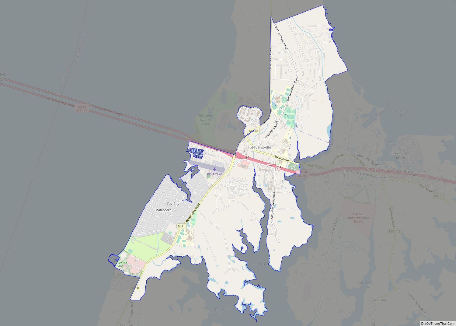
Stevensville is a census-designated place (CDP) in Queen Anne’s County, Maryland, United States, and is the county’s most populous place among both CDPs and municipalities. The community is the eastern terminus of the Chesapeake Bay Bridge. The Stevensville Historic District is one of two registered historic districts in the county, the other being the Centreville … Read more

Map of St. Michaels town, Maryland

Map of St. Michaels town, Maryland

Saint Michaels, also known as St. Michaels, is a town in Talbot County, Maryland, United States. The population was 1,029 at the 2010 census. Saint Michaels derives its name from the Episcopal Parish established there in 1677. The church attracted settlers who engaged in tobacco growing and ship building. St. Michaels town overview: Name: St. … Read more

Map of St. Leonard CDP

Map of St. Leonard CDP

St. Leonard CDP overview: Name: St. Leonard CDP LSAD Code: 57 LSAD Description: CDP (suffix) State: Maryland County: Calvert County FIPS code: 2469675 Online Interactive Map St. Leonard online map. Source: Basemap layers from Google Map, Open Street Map (OSM), Arcgisonline, Wmflabs. Boundary Data from Database of Global Administrative Areas. St. Leonard location map. Where … Read more

Map of Suitland CDP

Map of Suitland CDP

Suitland is an unincorporated community and census designated place (CDP) in Prince George’s County, Maryland, approximately one mile (1.6 km) southeast of Washington, D.C. As of the 2020 census, its population was 25,839. Prior to 2010, it was part of the Suitland-Silver Hill census-designated place. Suitland CDP overview: Name: Suitland CDP LSAD Code: 57 LSAD Description: … Read more

Map of Sudlersville town

Map of Sudlersville town

Sudlersville is a town in the far northeastern corner of Queen Anne’s County, Maryland, United States. The ZIP code is 21668 and the area code is 410. The population was 497 at the 2010 census. It is perhaps best known as the hometown of Baseball Hall Of Fame slugger Jimmie Foxx. Other famous residents include … Read more

Map of Stockton CDP, Maryland

Map of Stockton CDP, Maryland

Stockton is a census-designated place (CDP) in Worcester County, Maryland, United States. The population was 92 at the 2010 census. It is part of the Salisbury, Maryland-Delaware Metropolitan Statistical Area. Stockton CDP overview: Name: Stockton CDP LSAD Code: 57 LSAD Description: CDP (suffix) State: Maryland County: Worcester County Elevation: 33 ft (10 m) Total Area: 1.71 sq mi (4.42 km²) … Read more

Map of Summerfield CDP, Maryland

Map of Summerfield CDP, Maryland

Summerfield is a census-designated place near Landover in Prince George’s County, Maryland. As of the 2020 census, the population was 14,758. It is a suburb of Washington, D.C. FedExField is located in Summerfield CDP, as is the Prince George’s County Sports and Learning Complex. Prior to the 2010 Census, the area was not covered by … Read more

Map of Sykesville town

Map of Sykesville town, Maryland

Sykesville is a small town in Carroll County, Maryland, United States. The town lies 20 miles (32 km) west of Baltimore and 40 miles (64 km) north of Washington D.C. The population was 4,436 at the 2010 census. BudgetTravel.com named Sykesville ‘Coolest Small Town in America’ in June 2016. Sykesville town overview: Name: Sykesville town LSAD Code: … Read more

Map of Swanton CDP

Map of Swanton CDP, Maryland

Swanton is an unincorporated area and census-designated place (CDP) in Garrett County, Maryland, United States. Swanton is close to several recreation areas, such as Deep Creek Lake State Park and Jennings Randolph Lake. A church and a post office are located in the downtown area. The population was 58 at the 2010 census. Anderson Chapel … Read more

Map of Taneytown city

Map of Taneytown city

Taneytown (/ˈtɔːnitaʊn/ TAW-nee-town, locally also /ˈtænitaʊn/) is a city in Carroll County, Maryland, United States. The population was 6,728 at the 2010 census. Taneytown was founded in 1754. Of the city, George Washington once wrote, “Tan-nee town is but a small place with only the Street through wch.(sic) the road passes, built on. The buildings … Read more

Map of Tall Timbers CDP

Map of Tall Timbers CDP

Tall Timbers is an unincorporated community and census-designated place in St. Mary’s County, Maryland, United States. Tall Timbers CDP overview: Name: Tall Timbers CDP LSAD Code: 57 LSAD Description: CDP (suffix) State: Maryland County: St. Mary’s County Total Area: 1.52 sq mi (3.94 km²) Land Area: 1.38 sq mi (3.56 km²) Water Area: 0.15 sq mi (0.38 km²) Total Population: 451 Population Density: 328.00/sq mi … Read more

Map of Takoma Park city

Map of Takoma Park city

Takoma Park is a city in Montgomery County, Maryland, United States. It is a suburb of Washington, and part of the Washington metropolitan area. Founded in 1883 and incorporated in 1890, Takoma Park, informally called “Azalea City”, is a Tree City USA and a nuclear-free zone. A planned commuter suburb, it is situated along the … Read more