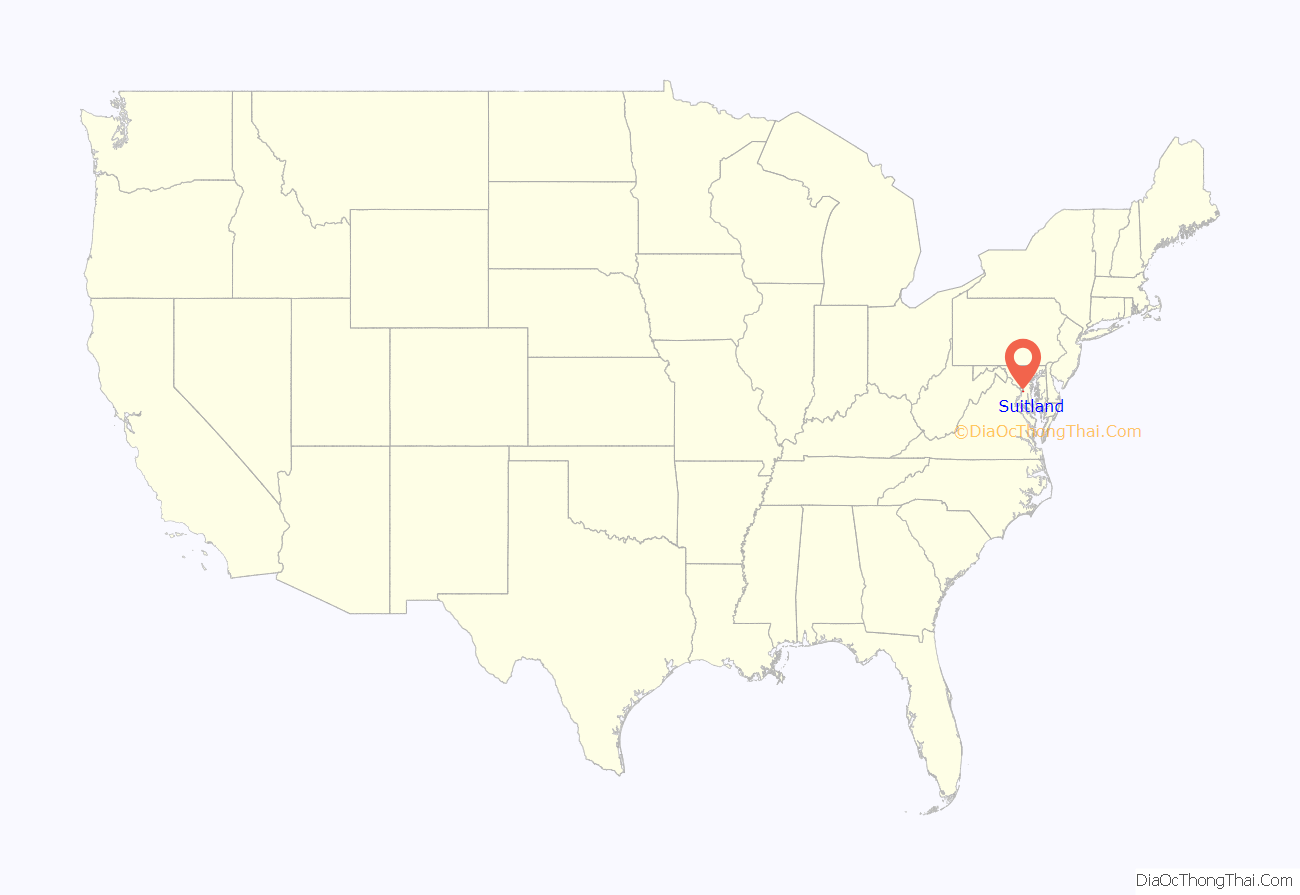
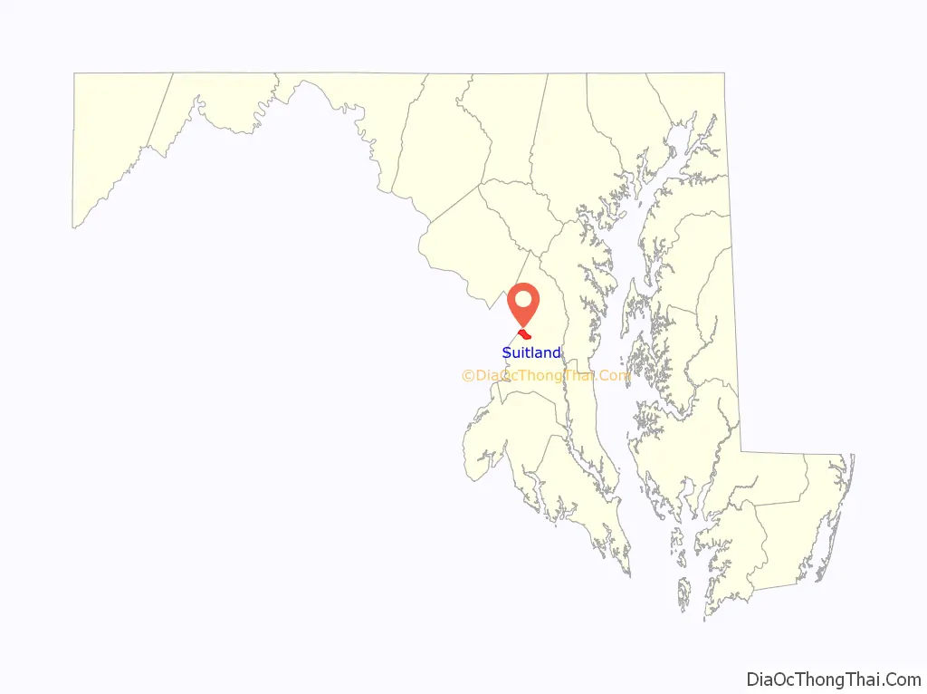
Suitland is an unincorporated community and census designated place (CDP) in Prince George’s County, Maryland, approximately one mile (1.6 km) southeast of Washington, D.C. As of the 2020 census, its population was 25,839. Prior to 2010, it was part of the Suitland-Silver Hill census-designated place.
| Name: | Suitland CDP |
|---|---|
| LSAD Code: | 57 |
| LSAD Description: | CDP (suffix) |
| State: | Maryland |
| County: | Prince George’s County |
| Elevation: | 290 ft (90 m) |
| Total Area: | 4.25 sq mi (11.01 km²) |
| Land Area: | 4.25 sq mi (11.00 km²) |
| Water Area: | 0.00 sq mi (0.01 km²) |
| Total Population: | 25,839 |
| Population Density: | 6,085.49/sq mi (2,349.49/km²) |
| Area code: | 301, 240 |
| FIPS code: | 2475725 |
Online Interactive Map
Click on ![]() to view map in "full screen" mode.
to view map in "full screen" mode.
Suitland location map. Where is Suitland CDP?
History
Suitland is named after 19th century landowner and businessman Senator Samuel Taylor Suit, whose estate, “Suitland,” was located near the present-day intersection of Suitland and Silver Hill Roads.
17th and 18th centuries
In the 1600s, the Piscataway tribe inhabited the lands in southern Maryland. European settlers first visited Saint Clement’s Island on the Potomac River and then established their first Maryland colony downriver at Saint Mary’s City in 1634, and by the 1660s through the 1680s, settlers had moved into what is now known as Prince George’s County. Faced with this encroachment, the Piscataways left the area in 1697, and moved north to what is now known as Coney Island. They eventually moved further north into Pennsylvania and Michigan. The sole export of the European settlers was tobacco, and slaves were first brought to the county in the 1700s.
19th century
Prior to the Civil War, tobacco production had made Prince George’s County one of the wealthiest counties in Maryland, and half of the county’s population was enslaved. After the war, old plantations were broken up and replaced by communities centered on small farming and country villages.
In 1867, Samuel Taylor Suit moved to Maryland and purchased more than 800 acres (320 ha) near Washington, D.C. In the 1870s and 1880s, such prominent guests as U.S. Presidents Ulysses S. Grant and Rutherford B. Hayes visited the Suitland estate. It was the 1871 site of negotiations preliminary to the international tribunal in Geneva that arbitrated the Alabama Claims. After Suit’s death in 1888, portions of the estate were sold (circa 1892 to 1903) to William A. Harrison, and the land was subsequently subdivided and sold over the years. Suit’s son, Arthur B. Suit, retained three acres (1.2 ha) of land near the corner of Suitland and Silver Hill Roads, where he maintained a general store, a bar, a bowling alley, and the community’s one-room jailhouse.
20th century
By the turn of the century, the village of Suitland had added a post office, churches, and several houses. On August 10, 1909, local residents met at the home of George J. Hess and organized the Suitland Improvement Association of Maryland to raise funds for a community meeting hall. Three officers were elected to serve one-year posts: President, Dr. C. M. Emmons; Vice President, C. L. Jenkins; and Secretary and Treasurer, George J. Hess. The Association was incorporated on November 17, 1950 and is now known as the Suitland Civic Association.
There are two historic cemeteries in Suitland: Cedar Hill and Lincoln Memorial. Cedar Hill Cemetery was founded in 1895 and built on the former Nonesuch Plantation. Prior to 1913, it was known as Forest Lake Cemetery and was likely renamed after the cedar trees that lined both sides of Suitland Road from the D.C. line to Silver Hill Road. Early churches performed baptisms at this location and it is also the burial site for victims of the 1906 Terra Cotta Railroad wreck. Lincoln Memorial Cemetery was founded in 1927 on the former Landon dairy farm and is the site where many prominent African-Americans are buried. Individuals include Dr. Charles Richard Drew, who established improved techniques for blood storage and developed large scale blood banks early in World War II, and Nannie Helen Burroughs, educator and civil rights activist.
The first one-room schoolhouse was built in 1891 on land purchased by the community. A two-room schoolhouse was later built in 1915 on Silver Hill Road, expanded to four rooms in 1922, and saw additions to the building in 1928, 1941, and 1957.
Property owned by James West and Joseph Friday, located near the current intersection of Swann and Silver Hill Roads, was used as an airfield from 1938 to 1941. Named “Skyhaven” by a local student who won the naming contest sponsored by West and Friday, Skyhaven Airfield hosted a flying club that served 20 small planes, including Wacos, Great Lakes, and Pipers.
Suitland remained a rural farming community until the onset of World War II. To meet the need for additional office space to support the war effort, in September 1941, the Public Buildings Administration awarded a $2,749,000 contract to McCloskey and Co. of Philadelphia to develop a new federal office building in Prince George’s County, Maryland. Later that year, 437 acres (177 ha) of farm and dairy land were purchased in Suitland to build the Suitland Federal Center. The 12 existing residences on this property included the former dairy and summer home of Albert Carry, the German-American founder of the National Capital Brewing Company and the Carry Ice Cream Co. The Suitland House, built by Lowell O. Minear, a pioneer designer of memorial parks, is the sole remaining residence on the Federal Center property. A colonial-revival style home, it now serves as office space for the U.S. Census Bureau and is included in the Prince George’s County Planning Department’s 2010 Approved Historic Sites and Districts Plan.
In 1942, the Suitland Manor apartments were built in anticipation of new federal workers. Parkway Terrace, Whitehall Square, and Marlborough House developments soon followed to accommodate the influx of Census Bureau and other federal employees. In 1943, the Census Bureau turned 14 acres (5.7 ha) of land at the Federal Center site into the largest Victory Garden in the Washington metropolitan area. The land was a parceled into 616 plots and plowed, fertilized, and tended by census employees. As late as 1989, 110 garden plots were still available for summer rental on a first-come, first-served basis for $7.00 each. These gardens were located at the site of the current Naval Intelligence Building.
In 1944, the Suitland Parkway was opened to connect the Army’s Bolling Air Force Base (Bolling Field) to the Camp Springs Army Military Reservation, later named Andrews Air Force Base and now known as Joint Base Andrews. The 9.35 miles (15.05 km) of highway, originally named the Fighter Command Station Access Parkway, was initially limited to military use only and came under the jurisdiction of the National Park Service in 1949.
Suitland Junior-Senior High School, was the first high school in Suitland. The building was dedicated on November 15, 1951 to the high ideal of freedom of education, with John W. McNamara presiding as master-of-ceremonies and principal Thomas Warthen accepting the dedication on behalf of the students and faculty. Nearby was also LaReine High School, offering a Roman Catholic education for girls. LaReine was eventually closed, and its students transferred to nearby Bishop McNamara High School which became co-educational.
The 1950s and 1960s were a period of major growth for Suitland, as new middle and working-class families settled into the newly built residential communities. However, this population boom came to an end around 1970 due to several converging factors. These included the availability of cheaper land and lower taxes in neighboring county jurisdictions; the ending of the postwar baby boom; the slowdown in the rate of federal government growth; and migration patterns spurred by school busing mandates leading to regional demographic shifts.
The 1970s were both the beginning of a period of population adjustment and a recognition of Suitland’s unique local history. Beginning in 1973, Prince George’s County became the largest school district to adopt a busing plan after the Supreme Court’s ruling on Brown v. Board of Education. The demographic changes caused by desegregation busing changed the county, transforming a great number of neighborhoods that were formerly white and middle-class to majority black and middle-class, and these shifts are reflected in the current population demographic of the Suitland CDP.
In 1975, local historian Darlie Norton was elected to draft a local history of the township in preparation for Suitland’s centennial celebration. A History of Suitland, Maryland, 1867–1976 (1976) includes a detailed history of early residents, businesses, land purchases, and the development of Suitland civic, public, and private enterprises. That same year, local resident Walter Coley organized a committee within the Suitland Civic Association to preserve the Suitland Bog, which led to the purchase of 20 acres (8.1 ha) of woods and wetland by the Maryland National Capitol Park and Planning Commission.
In the 1980s, crime associated with vandalism, property violations, landlord absenteeism, and drugs were seen as a threat to the federal workers who were now commuting into Suitland from outside the community, and in 1983, a razor wired fence was erected around the Federal Center complex. Through most of this decade, neighborhoods near the Federal Center remained distressed and in need of a plan for positive change and growth.
In the mid-1990s, county executive Wayne Curry conceived a plan to revitalize Suitland as part of a greater county-wide effort to improve townships located inside the Beltway. In 1997, as the first stage of the Prince George’s County Redevelopment Authority project to reduce local crime rates and revitalize the site, the Manchester Square housing development was turned over to the county. Two years later, the fence surrounding the Federal Center was replaced with a regular wrought iron fence. Notoriously in 2003, two business women in their 70s were murdered during a robbery at their retail flower shop on Suitland Road. As of Spring 2019, most of the retail district along Suitland Road across from the Census Bureau has been torn down, with plans for building new residential/retail ventures finally moving forward.
21st century
The Suitland station on the Washington Metro’s Green Line opened to the public January 13, 2001.
In 2004, Windsor Crossing, a $45 million multifamily condominium complex built by Stavrou Associates in partnership with the Prince George’s Redevelopment Authority, was completed on the former Manchester Square development. In 2005, the $15.7 million Suitland Elementary School was opened to the public as part of the revitalization plan. The defense departments Base Realignment Commission initiatives resulted in major changes at Andrews Air Force Base with hundreds of new employment positions anticipated over the coming decades.
In 2006, multi-million-dollar federal renovations of the U.S. Census Building and National Oceanic and Atmospheric headquarters were completed. On October 1, 2009, Andrews Air Force Base, along with Naval Air Facility Washington, became a joint base known as Joint Base Andrews Naval Air Facility Washington, or Joint Base Andrews. Renovations were completed at the Spauldings Branch Library in 2012, which while located in District Heights, MD also serves Suitland and surrounding communities.
Recent developments in Suitland include a double-digit fall in crime rates and increased development in the surrounding county. These include National Harbor to the south, Konterra to the north, Joint Base Andrews to the east of town, and the continuing development and/or gentrification of southeast Washington D.C. to the west. Several currently under-utilized Metro Stations in or around Suitland promise further development, as does recent legislation permitting gaming/casinos to be located in National Harbor. Two more revitalization projects were announced to the public in 2012: the “Buy Suitland” initiative and the Green Suitland Neighborhood Stabilization Project.
The “Buy Suitland” initiative offers up to 5% purchase price to first time home buyers, up to 7% purchase price to local civic workers, or 35% of purchase price or $40,000 to debt-to-income candidates for properties located in 11 census tracts. Green Suitland NSP is allocating over $2 million for the purchase of foreclosed and abandoned homes to be rehabilitated with enviro-friendly, cost-saving upgrades before they are resold.
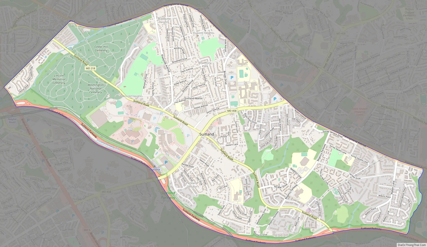
Suitland Road Map
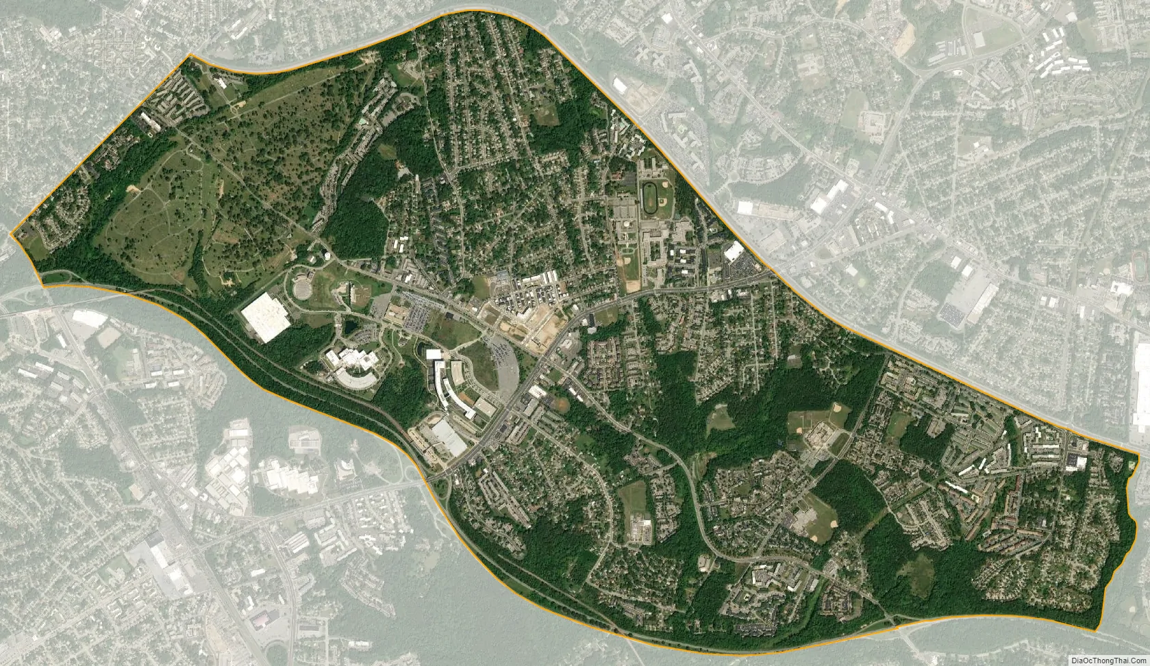
Suitland city Satellite Map
Geography
As an unincorporated area, Suitland’s boundaries are not officially defined. The U.S. Geological Survey locates the center of Suitland at 38°50’49″N 76°55’33″W. This area is roughly bounded by Southern Avenue (D.C. Line) to the north, Branch Avenue (MD 5) to the west, Pennsylvania Avenue (MD 4) to the east, and Donnell Drive/Suitland Parkway/Meadowbrook Drive (Henson Creek) to the south. Within the northeastern section of these boundaries lies the township of Morningside, MD and a small portion of another unincorporated area known as Forestville, MD.
According to the U.S. Census Bureau, Suitland has a total area of 4.2 square miles (11.0 km), a 25% reduction from the 2.2 square miles (5.6 km) used in previous years. While the Census Bureau defines the CDP as all land, the Suitland Bog and portions of Henson Creek, a tributary of the Potomac, are located off Suitland Parkway near the southern border of the CDP.
Suitland Bog is one of the last of the natural bogs in the D.C. region, which numbered approximately thirty before the onset of suburban development. This wetland ecosystem features sweet bay magnolias and other rare species of plants, including northern pitcher-plants, lady slipper orchids, sundews, and sphagnum moss.
Parks and recreation
There are two community recreation centers (Bradbury Heights Recreation Center and William Beanes Community Center) and 4 parks (Auth Village Neighborhood Park, Douglas Patterson Community Park, Dupont Heights Neighborhood Park, and Michael J. Polley Neighborhood Park) maintained by the Prince George’s County Department of Parks and Recreation.
See also
Map of Maryland State and its subdivision: Map of other states:- Alabama
- Alaska
- Arizona
- Arkansas
- California
- Colorado
- Connecticut
- Delaware
- District of Columbia
- Florida
- Georgia
- Hawaii
- Idaho
- Illinois
- Indiana
- Iowa
- Kansas
- Kentucky
- Louisiana
- Maine
- Maryland
- Massachusetts
- Michigan
- Minnesota
- Mississippi
- Missouri
- Montana
- Nebraska
- Nevada
- New Hampshire
- New Jersey
- New Mexico
- New York
- North Carolina
- North Dakota
- Ohio
- Oklahoma
- Oregon
- Pennsylvania
- Rhode Island
- South Carolina
- South Dakota
- Tennessee
- Texas
- Utah
- Vermont
- Virginia
- Washington
- West Virginia
- Wisconsin
- Wyoming


