Map of West Pocomoke CDP

Map of West Pocomoke CDP

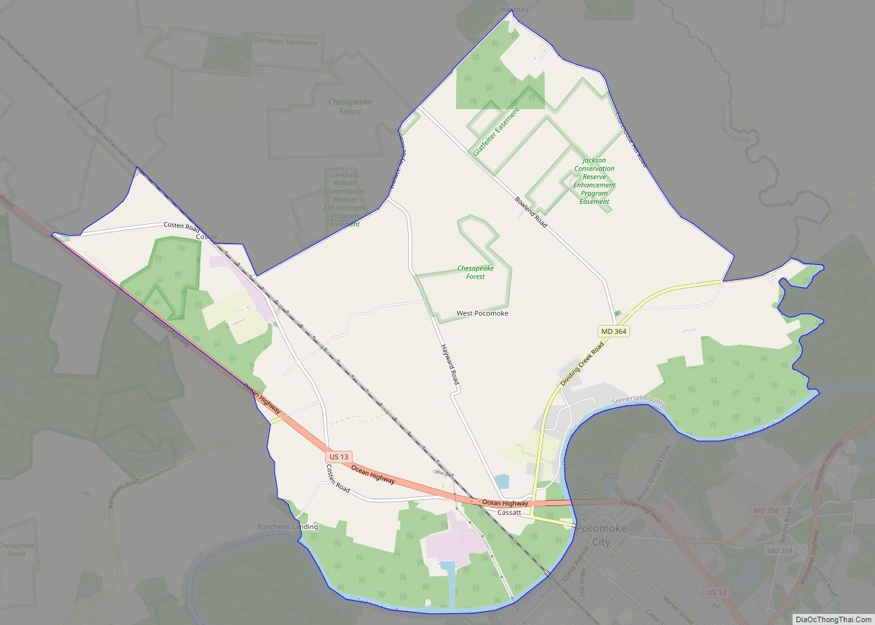
West Pocomoke is a census-designated place (CDP) in Somerset County, Maryland, United States. The population was 498 at the 2000 census. It is included in the Salisbury, Maryland-Delaware Metropolitan Statistical Area. West Pocomoke CDP overview: Name: West Pocomoke CDP LSAD Code: 57 LSAD Description: CDP (suffix) State: Maryland County: Somerset County Elevation: 20 ft (6 m) Total … Read more

Map of West Ocean City CDP

Map of West Ocean City CDP

West Ocean City CDP overview: Name: West Ocean City CDP LSAD Code: 57 LSAD Description: CDP (suffix) State: Maryland County: Worcester County FIPS code: 2483225 Online Interactive Map West Ocean City online map. Source: Basemap layers from Google Map, Open Street Map (OSM), Arcgisonline, Wmflabs. Boundary Data from Database of Global Administrative Areas. West Ocean … Read more

Map of West Laurel CDP

Map of West Laurel CDP

West Laurel is an unincorporated area and census-designated place (CDP) in Prince George’s County, Maryland, United States. Per the 2020 census, the population was 4,428. West Laurel CDP overview: Name: West Laurel CDP LSAD Code: 57 LSAD Description: CDP (suffix) State: Maryland County: Prince George’s County Elevation: 351 ft (107 m) Total Area: 2.36 sq mi (6.13 km²) Land Area: … Read more

Map of Westminster city, Maryland

Map of Westminster city, Maryland

Westminster is a city in northern Maryland, United States. It is the seat of Carroll County. The city’s population was 19,960 at the 2020 census. Westminster is an outlying community within the Baltimore-Towson, MD MSA, which is part of a greater Washington-Baltimore-Northern Virginia, DC-MD-VA-WV CSA. Westminster city overview: Name: Westminster city LSAD Code: 25 LSAD … Read more

Map of Westernport town

Map of Westernport town

Westernport is a town in Allegany County, Maryland, United States, along the Georges Creek Valley. It is part of the Cumberland, MD-WV Metropolitan Statistical Area. The population was 1,888 at the 2010 census. Westernport town overview: Name: Westernport town LSAD Code: 43 LSAD Description: town (suffix) State: Maryland County: Allegany County Incorporated: 1859 Elevation: 922 ft … Read more

Map of Westphalia CDP, Maryland

Map of Westphalia CDP, Maryland

Westphalia is a census-designated place in southern Prince George’s County, Maryland, United States. The population of the CDP was 11,770 at the 2020 census. Westphalia CDP overview: Name: Westphalia CDP LSAD Code: 57 LSAD Description: CDP (suffix) State: Maryland County: Prince George’s County Elevation: 180 ft (50 m) Total Area: 9.91 sq mi (25.68 km²) Land Area: 9.91 sq mi (25.66 km²) Water … Read more

Map of White Marsh CDP

Map of White Marsh CDP

White Marsh is an unincorporated community and census-designated place in Baltimore County, Maryland, United States. The population was 9,513 at the 2010 census. White Marsh is a northeast suburb of Baltimore. White Marsh CDP overview: Name: White Marsh CDP LSAD Code: 57 LSAD Description: CDP (suffix) State: Maryland County: Baltimore County Founded: 1965 Elevation: 52 ft … Read more

Map of Wheaton CDP, Maryland

Map of Wheaton CDP, Maryland

Wheaton is a census-designated place in Montgomery County, Maryland, United States, situated north of Washington, D.C., and northwest of downtown Silver Spring. Wheaton takes its name from Frank Wheaton (1833–1903), a career officer in the United States Army and volunteer from Rhode Island in the Union Army who rose to the rank of major-general while … Read more

Map of Whaleyville CDP

Map of Whaleyville CDP

Whaleyville is a census-designated place in Worcester County, Maryland, United States. The population was 149 at the 2010 census. It is part of the Salisbury, Maryland-Delaware Metropolitan Statistical Area. Whaleyville CDP overview: Name: Whaleyville CDP LSAD Code: 57 LSAD Description: CDP (suffix) State: Maryland County: Worcester County Elevation: 30 ft (9 m) Total Area: 1.01 sq mi (2.63 km²) Land … Read more

Map of Willards town

Map of Willards town

Willards is a town in Wicomico County, Maryland, United States. The population was 958 at the 2010 census. It is included in the Salisbury, Maryland-Delaware Metropolitan Statistical Area. Willards town overview: Name: Willards town LSAD Code: 43 LSAD Description: town (suffix) State: Maryland County: Wicomico County Incorporated: 1906 Elevation: 33 ft (10 m) Total Area: 1.15 sq mi (2.97 km²) … Read more

Map of Whitehaven CDP

Map of Whitehaven CDP

Whitehaven is an unincorporated community and census-designated place in Wicomico County, Maryland, United States. Its population was 43 as of the 2010 census. It is part of the Salisbury, Maryland-Delaware Metropolitan Statistical Area. Whitehaven is home to the Whitehaven Ferry, one of the few remaining public ferries in Maryland, and was once a thriving settlement … Read more

Map of White Oak CDP

Map of White Oak CDP, Maryland

White Oak is a census-designated place and an unincorporated area in Montgomery County, Maryland, United States. It had a population of 16,347 in 2020. White Oak was known for its Naval Ordnance Laboratory, which was closed in 1994. The headquarters of the Food and Drug Administration now occupies the property, which has been renamed the … Read more