Map of Caspian city

Map of Caspian city

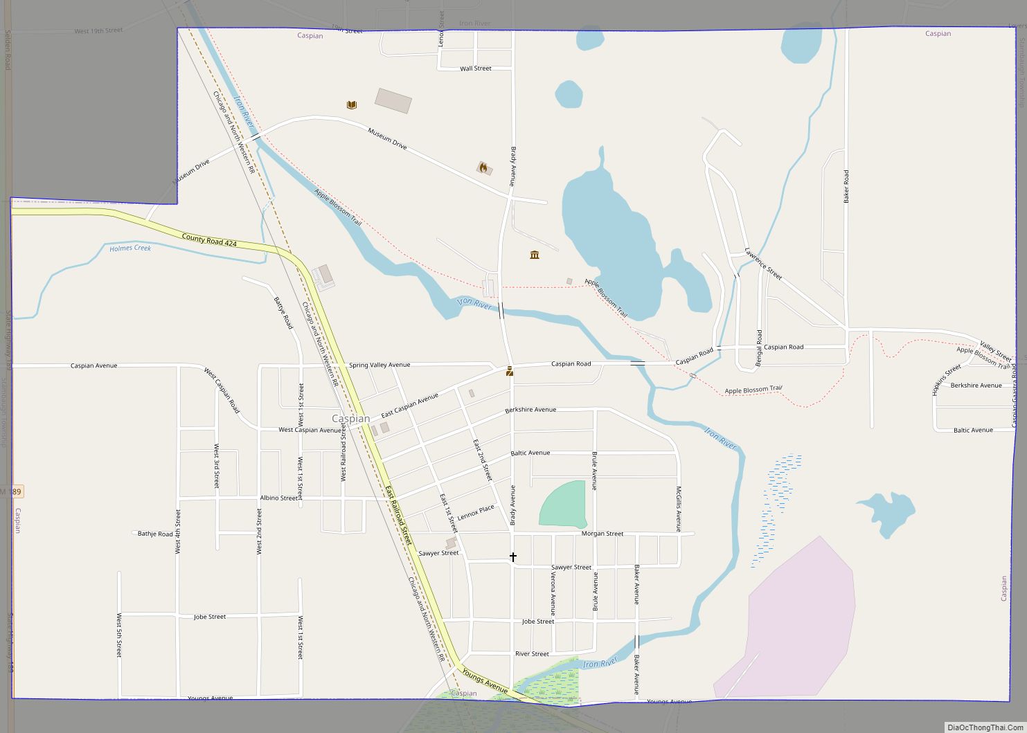
Caspian is a city in Iron County in the U.S. state of Michigan. The population was 906 at the time of the 2010 census. The city has an Italian heritage. Caspian city overview: Name: Caspian city LSAD Code: 25 LSAD Description: city (suffix) State: Michigan County: Iron County Elevation: 1,496 ft (456 m) Total Area: 1.43 sq mi (3.69 km²) … Read more

Map of Casnovia village

Map of Casnovia village

Casnovia is a village in the U.S. state of Michigan. It is situated on the boundary between Muskegon and Kent counties and lies partially within both. The population was 319 at the 2010 census. The village is located partially within Tyrone Township. Casnovia village overview: Name: Casnovia village LSAD Code: 47 LSAD Description: village (suffix) … Read more

Map of Caseville city

Map of Caseville city

Caseville is a city in Huron County in the U.S. state of Michigan, located at the mouth of the Pigeon River on Saginaw Bay of Lake Huron. The population was 652 at the 2020 census. The city is surrounded by Caseville Township. A popular destination for summer tourists, it sponsors the 10-day Cheeseburger in Caseville … Read more

Map of Central Lake village

Map of Central Lake village

Central Lake is a village in Antrim County in the U.S. state of Michigan. The population was 952 at the 2010 census. The village is located within Central Lake Township. Central Lake is situated on a lake which is in the center of a chain of lakes and rivers in the county, hence the name. … Read more

Map of Center Line city

Map of Center Line city

Center Line is a city in Macomb County in the U.S. state of Michigan, surrounded entirely by the city of Warren. The population was 8,257 at the 2010 census. Center Line city overview: Name: Center Line city LSAD Code: 25 LSAD Description: city (suffix) State: Michigan County: Macomb County Incorporated: 1925 (village)1936 (city) Elevation: 620 ft … Read more

Map of Cement City village

Map of Cement City village

Cement City is a village in the U.S. state of Michigan. The village is located within Woodstock Township in Lenawee County, with a small northern portion within Columbia Township in Jackson County. The population was 438 at the 2010 census. Cement City village overview: Name: Cement City village LSAD Code: 47 LSAD Description: village (suffix) … Read more

Map of Cedar CDP, Michigan

Map of Cedar CDP, Michigan

Cedar is an unincorporated community and census-designated place in Leelanau County in the U.S. State of Michigan. The CDP had a population of 102 at the 2020 census. Cedar is located within Solon Township, and lies about 10 miles (16 km) northwest of Traverse City. The town is known for its Polish heritage, and is home … Read more

Map of Cedar Springs city, Michigan

Map of Cedar Springs city, Michigan

Cedar Springs is a city in Kent County in the U.S. state of Michigan. The population was 3,509 at the 2010 census. Cedar Springs is a northern city of the Grand Rapids metropolitan area and is about 20 miles (32.2 km) north of Grand Rapids. Cedar Springs city overview: Name: Cedar Springs city LSAD Code: 25 … Read more

Map of Charlevoix city

Map of Charlevoix city

Charlevoix (/ˈʃɑːrləvɔɪ/ SHAR-lə-voy) is a city in the U.S. state of Michigan. It is the county seat of Charlevoix County. Part of Northern Michigan, Charlevoix is located on an isthmus between Lake Michigan and Lake Charlevoix, bisected by the short Pine River. Charlevoix serves as the main access point for Beaver Island, the largest island … Read more

Map of Centreville village, Michigan

Map of Centreville village, Michigan

Centreville is a village in the U.S. state of Michigan and the county seat of St. Joseph County. The population was 1,425 at the 2010 census. Centreville village overview: Name: Centreville village LSAD Code: 47 LSAD Description: village (suffix) State: Michigan County: St. Joseph County Elevation: 820 ft (250 m) Total Area: 1.49 sq mi (3.87 km²) Land Area: 1.48 sq mi … Read more

Map of Cheboygan city

Map of Cheboygan city

Cheboygan (/ʃəˈbɔɪɡən/ shə-BOY-gən) is a city in the U.S. state of Michigan. It is the county seat and largest settlement of Cheboygan County. At the 2020 census, Cheboygan had a population 4,770. Cheboygan is situated upon Lake Huron, located at the mouth of the eponymous Cheboygan River. Cheboygan is the fourth-largest American city on Lake … Read more

Map of Chatham village, Michigan

Map of Chatham village, Michigan

Chatham is a village in Alger County in the U.S. state of Michigan. It is located within Rock River Township. The population was 220 at the 2010 census. The village is located along M-94 about 15 miles (24 km) southwest of the city of Munising. It was named after Chatham, Ontario, Canada, the town where the … Read more