Map of Greenville city, Michigan

Map of Greenville city, Michigan

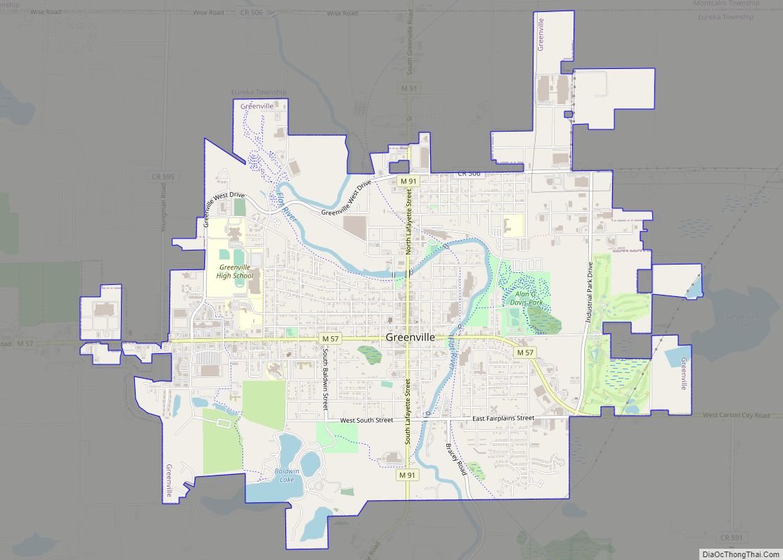
Greenville is a city in Montcalm County of the U.S. state of Michigan. The population was 8,816 at the 2020 census. Greenville city overview: Name: Greenville city LSAD Code: 25 LSAD Description: city (suffix) State: Michigan County: Montcalm County Founded: 1844 Incorporated: 1867 (village)1871 (city) Elevation: 840 ft (260 m) Total Area: 6.65 sq mi (17.23 km²) Land Area: 6.34 sq mi … Read more

Map of Grayling city, Michigan

Map of Grayling city, Michigan

Grayling (/ˈɡreɪlɪŋ/ GRAY-ling) is a city and the county seat of Crawford County in the U.S. state of Michigan. It is the only incorporated community in Crawford County. The population was 1,884 at the 2010 census. The city is surrounded by Grayling Charter Township, but the two are administered autonomously. The city is located in … Read more

Map of Grawn CDP

Map of Grawn CDP

Grawn (/ɡrɔːn/) is an unincorporated community and census-designated place (CDP) in Grand Traverse County in the U.S. state of Michigan. At the 2020 census, the community’s population was 816. The community is located within Blair Township, on the border witih Green Lake Township. Grawn CDP overview: Name: Grawn CDP LSAD Code: 57 LSAD Description: CDP … Read more

Map of Grass Lake village

Map of Grass Lake village

Grass Lake is a village in Jackson County in the U.S. state of Michigan. The population was 1,173 at the 2010 census. The village is located just south of Interstate 94 in Grass Lake Township. Grass Lake village overview: Name: Grass Lake village LSAD Code: 47 LSAD Description: village (suffix) State: Michigan County: Jackson County … Read more

Map of Grosse Pointe Woods city

Map of Grosse Pointe Woods city

Grosse Pointe Woods is a city in Wayne County in the U.S. state of Michigan. The population was 16,135 at the 2010 census. The city is a northeastern suburb of Metro Detroit and shares a small southern border with the city of Detroit. It is part of the Grosse Pointe collection of cities and the … Read more

Map of Grosse Pointe Park city

Map of Grosse Pointe Park city

Grosse Pointe Park is a city in Wayne County in the U.S. state of Michigan. The population was 11,555 at the 2010 census. Bordering on Detroit with frontage on southern Lake St. Clair, it is the southernmost of the Grosse Pointe suburbs. Grosse Pointe Park was incorporated as a village in 1907 and again as … Read more

Map of Grosse Pointe Farms city

Map of Grosse Pointe Farms city

Grosse Pointe Farms is a city in Wayne County in the U.S. state of Michigan. The population was 9,479 at the 2010 census. As part of the Grosse Pointe collection of cities, it is a northeastern city of Metro Detroit and shares a small western border with the city of Detroit. Grosse Pointe Farms was … Read more

Map of Gwinn CDP

Map of Gwinn CDP

Gwinn is an unincorporated community in Marquette County in the U.S. state of Michigan. It is a census-designated place (CDP) for statistical purposes and has no legal status as an incorporated municipality. The population of the CDP was 1,784 at the 2020 census. The community is located within Forsyth Township. The CDP includes the nearby … Read more

Map of Grosse Pointe city

Map of Grosse Pointe city

Grosse Pointe is a city in Wayne County in the U.S. state of Michigan. As of the 2010 census, the city had a population of 5,421. Grosse Pointe is an eastern suburb of Metro Detroit along Lake St. Clair. It is located along East Jefferson Avenue and shares a small northwestern border with the city … Read more

Map of Harbor Springs city

Map of Harbor Springs city

Harbor Springs is a city and resort community in Emmet County, Michigan. The population was 1,194 in the 2010 census. Harbor Springs is in a sheltered bay on the north shore of the Little Traverse Bay on Lake Michigan. The Little Traverse Lighthouse is a historic lighthouse on the Harbor Point peninsula, which shelters the … Read more

Map of Harbor Beach city

Map of Harbor Beach city

Harbor Beach is a city in Huron County in the U.S. state of Michigan. The population was 1,604 at the 2020 census. Harbor Beach city overview: Name: Harbor Beach city LSAD Code: 25 LSAD Description: city (suffix) State: Michigan County: Huron County Incorporated: 1910 (city) Elevation: 600 ft (183 m) Total Area: 2.06 sq mi (5.33 km²) Land Area: 1.72 sq mi … Read more

Map of Hanover village, Michigan

Map of Hanover village, Michigan

Hanover is a village in Jackson County in the U.S. state of Michigan. The population was 441 at the 2010 census. The village is located within Hanover Township. Hanover village overview: Name: Hanover village LSAD Code: 47 LSAD Description: village (suffix) State: Michigan County: Jackson County Elevation: 1,115 ft (340 m) Total Area: 0.44 sq mi (1.13 km²) Land Area: … Read more