Grayling (/ˈɡreɪlɪŋ/ GRAY-ling) is a city and the county seat of Crawford County in the U.S. state of Michigan. It is the only incorporated community in Crawford County. The population was 1,884 at the 2010 census. The city is surrounded by Grayling Charter Township, but the two are administered autonomously.
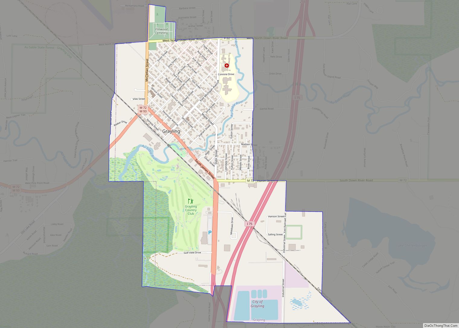
The city is located in the middle of the Northern Michigan region at the junctions of Interstate 75, U.S. Route 127, M-72, and M-93. Grayling is well known for hosting the Au Sable River Canoe Marathon in July of every year since 1947. The city is named after the Grayling species of fish once abundant in the Au Sable River, although the species has long since been extinct in the area. There have been many attempts to bring Grayling back to the area but none have been successful.
| Name: | Grayling city |
|---|---|
| LSAD Code: | 25 |
| LSAD Description: | city (suffix) |
| State: | Michigan |
| County: | Crawford County |
| Founded: | 1872 |
| Elevation: | 1,138 ft (347 m) |
| Total Area: | 2.08 sq mi (5.39 km²) |
| Land Area: | 2.05 sq mi (5.31 km²) |
| Water Area: | 0.03 sq mi (0.08 km²) |
| Total Population: | 1,867 |
| Population Density: | 910.73/sq mi (351.71/km²) |
| Area code: | 989 |
| FIPS code: | 2634640 |
| GNISfeature ID: | 0627264 |
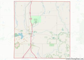
Online Interactive Map
Click on ![]() to view map in "full screen" mode.
to view map in "full screen" mode.
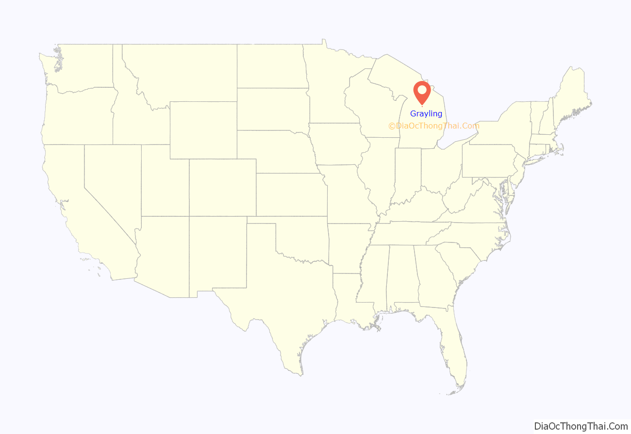
Grayling location map. Where is Grayling city?

History
Michael Shoat Hartwick was Grayling’s first settler. On the west side of the railroad tracks, he built a log hotel. The railroad platted out 40 acres (where Grayling now stands), naming it “Crawford”. Fish swimming in the river were identified as grayling, and it is said that the residents preferred the name “Grayling” to the name “Crawford,” and renamed the area after the fish.
Grayling’s access to two major rivers (Au Sable River and Manistee River), and the presence of the vast forest around it, made it important in the lumber era. Logs were floated down the rivers to the lakes.
Grayling had other names through the years. It was called “AuSable”, “Forest”, “Crawford Station”, and during the lumbering era “Milltown”.
The Arctic grayling that had inhabited much of Northern Michigan was eventually wiped out. The logging practice of using river beds to move logs in the springtime destroyed the breeding grounds for these fish. Before they could recover, non-native sport fish such as brook trout were introduced in the 1890s and competed with the grayling for food.
The Grayling Fish Hatchery was founded in 1914 by timber baron Rasmus Hanson (1846–1927). He hoped to restore the grayling to the Au Sable River system; ironically, its disappearance was caused, at least in part, by the massive habitat destruction caused by logging, which was the source of Mr. Hanson’s and other lumber barons’ immense wealth. Other famous contributors to the initial costs of the hatchery included Henry Ford, Edsel Ford, and Thomas Edison. The grayling became extinct in Michigan. Nevertheless, the hatchery continued to play an important role in natural resource conservation. In 1926, it was sold to the state of Michigan. It continued to be operated as a fish hatchery and tourist attraction until the mid-1960s. In 1995, Michigan sold the property to Crawford County. It is being operated by a privately owned fish farm, although continues to be open to the public during the summer.
An important person in the history of Grayling is Rasmus Hanson. Hanson was born in 1846 in Denmark and immigrated to the United States some time later. At age 16 he began working in the lumber field. Two years later, E. N. Salling, Nelson Michelson, and he organized the first Salling-Hanson Company. After nearly 50 years of service, the Salling Hanson Company had shut down its operation in January 1927. He was a successful entrepreneur and created many businesses in Northern Michigan. Along with being one of three lumber barons of Northern Michigan, Hanson owned the Michigan Sugar Company and the Bay City Sugar Company. In 1916, he donated 13,826 acres of cut-over land in Crawford County to the state of Michigan for use as a forest game preserve and military reservation. This land became the first state-owned game preserve. The area south of Lake Margrethe (named in honor of Hanson’s wife, Margrethe) continues to be used as a National Guard base that serves Michigan, Ohio, and Indiana guards. Since 1947, Grayling has been the starting point of the Au Sable River Canoe Marathon, which is held every year on the last weekend of July. This is the longest nonstop canoe race in North America.
Grayling Road Map

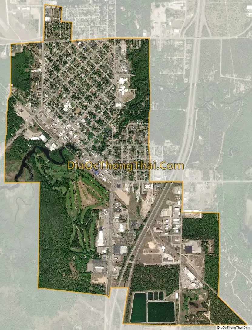
Grayling city Satellite Map
Geography
According to the United States Census Bureau, the city has a total area of 2.04 square miles (5.28 km), of which 2.01 square miles (5.21 km) is land and 0.03 square miles (0.08 km) (1.47%) is water.
- The middle branch of the Au Sable River passes through the city.
- According to the United States Census Bureau, the city has a total area of 2.04 square miles (5.28 km), of which 2.01 square miles (5.21 km) is land and 0.03 square miles (0.08 km) is water.
- Nearby Camp Grayling (donated by Rasmus Hanson) is the nation’s largest National Guard training site and the largest military installation east of the Mississippi River. 147,000 acres (590 km) are used for year-round training conducted by the U.S. National Guard, as well as active and reserve components of the Army, Air Force, Marine Corps and Navy.
- The city is near Lake Margrethe.
- Hartwick Pines State Park is just 7 miles (11 km) north and northeast of Grayling.
- The Huron portion of the Huron-Manistee National Forests is about the same distance due east.
- North Down River Road is east of the city along the Au Sable River, which runs parallel to it. It is a designated National Scenic Byway for the 23 miles (37 km) that go into Oscoda. The Lumberman’s Monument is located along the byway.
- An oilfield is located about 4 miles (6.4 km) south of M-93 on Military Road.
Geographic features
- Much of the area sits on the “Grayling outwash plain”, a unique habitat named for the city.
Climate
This climatic region has large seasonal temperature differences, with warm to hot (and often humid) summers and cold (sometimes severely cold) winters. According to the Köppen climate classification system, Grayling has a humid continental climate, Dfb on climate maps.
See also
Map of Michigan State and its subdivision:- Alcona
- Alger
- Allegan
- Alpena
- Antrim
- Arenac
- Baraga
- Barry
- Bay
- Benzie
- Berrien
- Branch
- Calhoun
- Cass
- Charlevoix
- Cheboygan
- Chippewa
- Clare
- Clinton
- Crawford
- Delta
- Dickinson
- Eaton
- Emmet
- Genesee
- Gladwin
- Gogebic
- Grand Traverse
- Gratiot
- Hillsdale
- Houghton
- Huron
- Ingham
- Ionia
- Iosco
- Iron
- Isabella
- Jackson
- Kalamazoo
- Kalkaska
- Kent
- Keweenaw
- Lake
- Lake Hurron
- Lake Michigan
- Lake St. Clair
- Lake Superior
- Lapeer
- Leelanau
- Lenawee
- Livingston
- Luce
- Mackinac
- Macomb
- Manistee
- Marquette
- Mason
- Mecosta
- Menominee
- Midland
- Missaukee
- Monroe
- Montcalm
- Montmorency
- Muskegon
- Newaygo
- Oakland
- Oceana
- Ogemaw
- Ontonagon
- Osceola
- Oscoda
- Otsego
- Ottawa
- Presque Isle
- Roscommon
- Saginaw
- Saint Clair
- Saint Joseph
- Sanilac
- Schoolcraft
- Shiawassee
- Tuscola
- Van Buren
- Washtenaw
- Wayne
- Wexford
- Alabama
- Alaska
- Arizona
- Arkansas
- California
- Colorado
- Connecticut
- Delaware
- District of Columbia
- Florida
- Georgia
- Hawaii
- Idaho
- Illinois
- Indiana
- Iowa
- Kansas
- Kentucky
- Louisiana
- Maine
- Maryland
- Massachusetts
- Michigan
- Minnesota
- Mississippi
- Missouri
- Montana
- Nebraska
- Nevada
- New Hampshire
- New Jersey
- New Mexico
- New York
- North Carolina
- North Dakota
- Ohio
- Oklahoma
- Oregon
- Pennsylvania
- Rhode Island
- South Carolina
- South Dakota
- Tennessee
- Texas
- Utah
- Vermont
- Virginia
- Washington
- West Virginia
- Wisconsin
- Wyoming