Map of Amasa CDP

Map of Amasa CDP

Amasa is an unincorporated community and census-designated place (CDP) in southern Hematite Township, Iron County, Michigan, in the United States. As of the 2010 census it had a population of 283. Amasa CDP overview: Name: Amasa CDP LSAD Code: 57 LSAD Description: CDP (suffix) State: Michigan County: Iron County Elevation: 1,441 ft (439 m) Total Area: 4.04 sq mi … Read more

Map of Alpha village, Michigan

Map of Alpha village, Michigan

Alpha is a village in Mastodon Township, Iron County of the U.S. state of Michigan. The population was 126 at the 2020 census. Alpha is the only village of Iron County. Alpha village overview: Name: Alpha village LSAD Code: 47 LSAD Description: village (suffix) State: Michigan County: Iron County Elevation: 1,424 ft (434 m) Total Area: 0.99 sq mi … Read more

Map of Alpena city, Michigan

Map of Alpena city, Michigan

Alpena (/ælˈpiːnə/ al-PEE-nə) is a city in the U.S. state of Michigan. It is the county seat of Alpena County, and is the only city within the county. The population was 10,197 at the 2020 census, making it the third most populated city in the Northern Michigan region, after Traverse City and Cadillac. The city … Read more

Map of Arcadia CDP, Michigan

Map of Arcadia CDP, Michigan

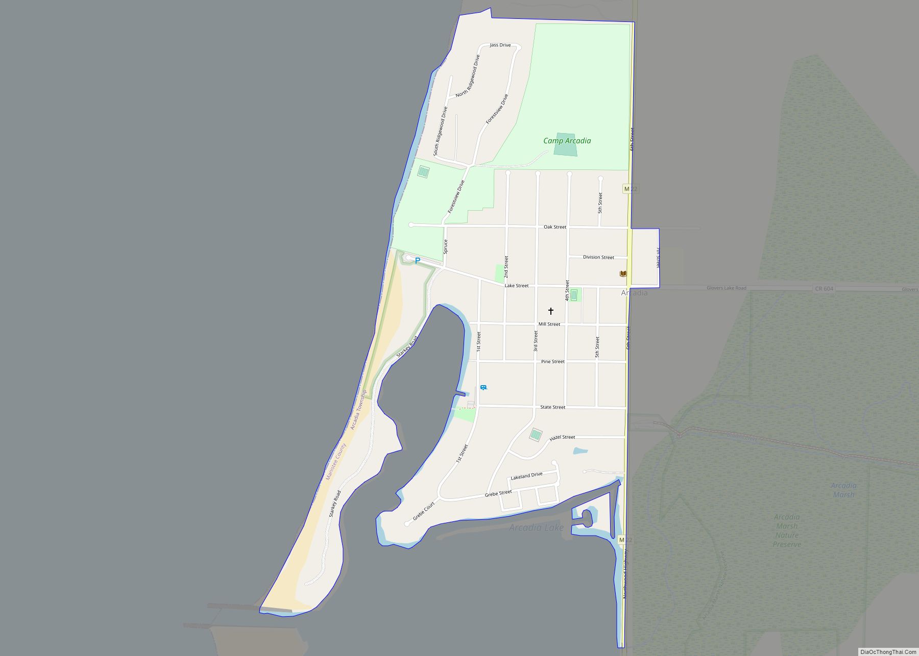
Arcadia is an unincorporated community and census-designated place in Arcadia Township, Manistee County, Michigan, United States. Its population was 291 as of the 2010 census. The community is located along M-22 and the Lake Michigan shore. Arcadia has a post office with ZIP code 49613. Arcadia CDP overview: Name: Arcadia CDP LSAD Code: 57 LSAD … Read more

Map of Atlanta CDP, Michigan

Map of Atlanta CDP, Michigan

Atlanta is an unincorporated community in the U.S. state of Michigan, along the 45th parallel. It is a census-designated place (CDP) for statistical purposes and does not have any legal status as an incorporated municipality. The population was 757 at the 2000 census. It is the county seat of Montmorency County. The community is centered … Read more

Map of Athens village, Michigan

Map of Athens village, Michigan

Athens is a village in Calhoun County in the U.S. state of Michigan. The population was 936 at the 2020 census. The village is located in southern Athens Township, and is part of the Battle Creek, Michigan Metropolitan Statistical Area. It was settled in 1831. Athens village overview: Name: Athens village LSAD Code: 47 LSAD … Read more

Map of Ashley village, Michigan

Map of Ashley village, Michigan

Ashley is a village in Gratiot County in the U.S. state of Michigan. The population was 508 at the 2020 census. The village is located in the northwest corner of Elba Township. No major state trunkline runs through the village, although M-57 passes within one mile to the south. Ashley was platted in 1884. Ashley … Read more

Map of Armada village

Map of Armada village

Armada (/ɑːrˈmeɪdə/ ar-MAY-duh) is a village in Macomb County in the U.S. state of Michigan. The population was 1,684 at the 2020 census. The village is located within Armada Township. It is best known for its annual Armada Fair. Armada village overview: Name: Armada village LSAD Code: 47 LSAD Description: village (suffix) State: Michigan County: … Read more

Map of Argentine CDP

Map of Argentine CDP

Argentine is an unincorporated community and census-designated place (CDP) in Argentine Township, Genesee County, in the U.S. state of Michigan. The population was 2,685 as of the 2020 census, up from 2,525 at the 2010 census. It was first settled in 1836. The area included in the CDP is the southeast corner of Argentine Township. … Read more

Map of Auburn city, Michigan

Map of Auburn city, Michigan

Auburn is a city in Bay County, Michigan, United States. The city’s population was 2,068 at the 2020 Census. It is included in the Saginaw, Midland, and Bay City metropolitan area. Auburn city overview: Name: Auburn city LSAD Code: 25 LSAD Description: city (suffix) State: Michigan County: Bay County Incorporated: 1947 Elevation: 617 ft (188 m) Total … Read more

Map of Auburn Hills city

Map of Auburn Hills city

Auburn Hills is a city in Oakland County in the U.S. state of Michigan. The population was 24,360 at the 2020 census. Before incorporating as a city in 1983, the area was part of the now-defunct Pontiac Township. It is home to Oakland University and the U.S. headquarters of Stellantis, BorgWarner and Volkswagen. The city … Read more

Map of Au Sable CDP

Map of Au Sable CDP

Au Sable (/ɔː ˈsɑːbəl/ aw SAH-bəl) is an unincorporated community and census-designated place (CDP) in the U.S. state of Michigan. The population of the CDP was 1,453 at the 2020 census. The community is located within Au Sable Township at the mouth of the Au Sable River along Lake Huron. Au Sable CDP overview: Name: … Read more