Map of Pinckney village

Map of Pinckney village

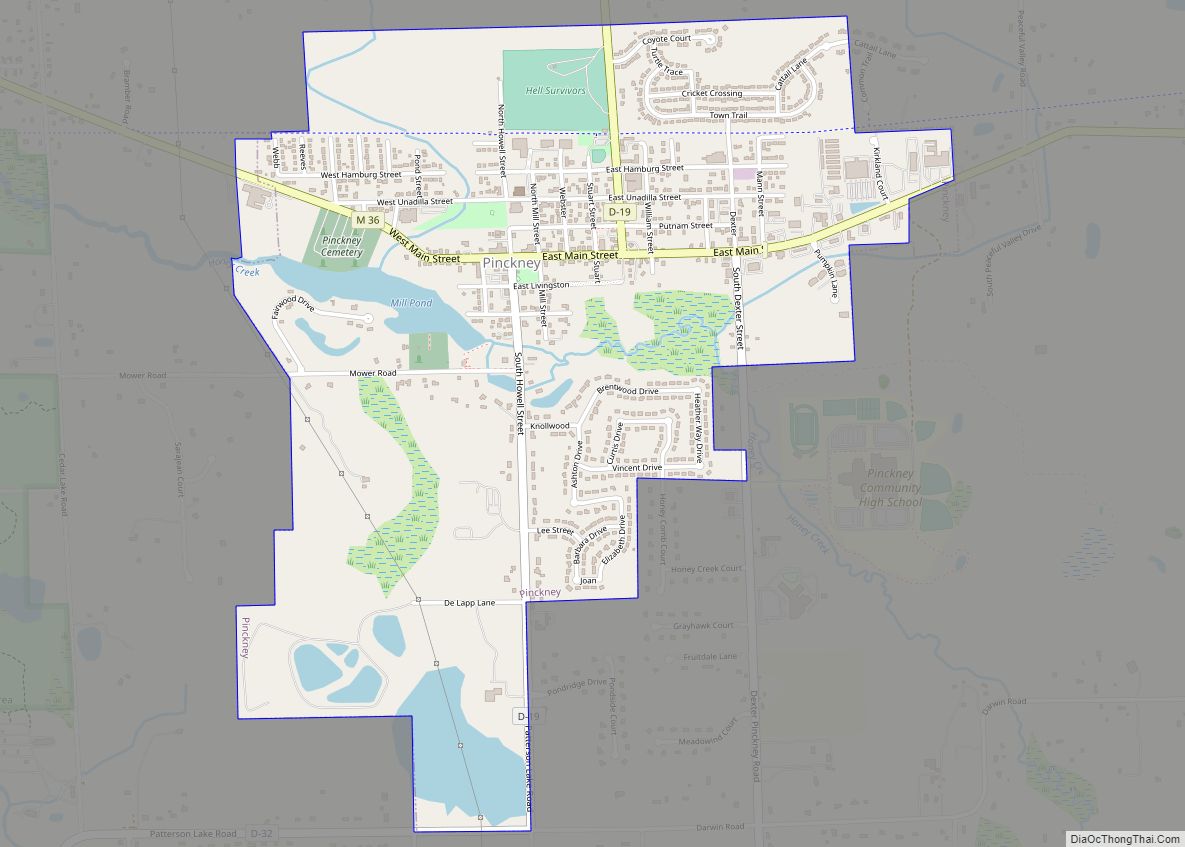
Pinckney is a village in Putnam Township, Livingston County in the U.S. state of Michigan. The population was 2,427 at the 2010 census. Among the first American pioneers in the area around Pinckney were William Kirkland and his family, who moved from New York in the late 1820s. Kirkland named the community after his brother, … Read more

Map of Pilgrim CDP

Map of Pilgrim CDP

Pilgrim is an unincorporated community and census-designated place (CDP) in Benzie County in the U.S. state of Michigan. At the 2010 census, the CDP had a permanent population of 11. Pilgrim is located within Crystal Lake Township. Pilgrim CDP overview: Name: Pilgrim CDP LSAD Code: 57 LSAD Description: CDP (suffix) State: Michigan County: Benzie County … Read more

Map of Port Hope village

Map of Port Hope village

Port Hope is a village in Huron County of the U.S. state of Michigan. The population was 267 at the 2010 census. The village is within Rubicon Township. Port Hope village overview: Name: Port Hope village LSAD Code: 47 LSAD Description: village (suffix) State: Michigan County: Huron County Elevation: 607 ft (185 m) Total Area: 1.01 sq mi (2.62 km²) … Read more

Map of Port Austin village

Map of Port Austin village

Port Austin is a village in Huron County in the U.S. state of Michigan. The population was 664 at the 2010 census. The village is within Port Austin Township. Port Austin village overview: Name: Port Austin village LSAD Code: 47 LSAD Description: village (suffix) State: Michigan County: Huron County Elevation: 597 ft (182 m) Total Area: 1.00 sq mi … Read more

Map of Pontiac city, Michigan

Map of Pontiac city, Michigan

Pontiac (/ˈpɒn(t)iæk/ POHN-(t)ee-ack) is a city in and the county seat of Oakland County in the U.S. state of Michigan. As of the 2020 census, the city had a total population of 61,606. A part of Metro Detroit, Pontiac is about 20 miles (32.2 km) northwest of Detroit. Founded in 1818, Pontiac was the second European-American … Read more

Map of Ponshewaing CDP

Map of Ponshewaing CDP

Ponshewaing (/ˈpɑːnʃəwæŋ/ PON-shə-WANG) is an unincorporated community and census-designated place (CDP) in Emmet County in the U.S. state of Michigan. As of the 2010 census, the CDP had a population of 69. It is located within Littlefield Township. Ponshewaing CDP overview: Name: Ponshewaing CDP LSAD Code: 57 LSAD Description: CDP (suffix) State: Michigan County: Emmet … Read more

Map of Plymouth city, Michigan

Map of Plymouth city, Michigan

Plymouth is a city in Wayne County, Michigan, United States. The population was 9,370 at the 2020 census. The city of Plymouth is surrounded by Plymouth Township, but the two are administered autonomously. Plymouth is a western suburb of Metro Detroit and is located about 10 miles (16.1 km) west of the city of Detroit. Plymouth … Read more

Map of Posen village, Michigan

Map of Posen village, Michigan

Posen is a village in Presque Isle County of the U.S. state of Michigan. The population was 234 at the 2010 census. The village is in Posen Township. Posen has a strong Polish background as 78.8% of its inhabitants are reported to have Polish ancestry. It is home to the Posen Potato Festival, held every … Read more

Map of Portland city, Michigan

Map of Portland city, Michigan

Portland is a city in Ionia County of the U.S. state of Michigan. The population was 3,883 at the 2010 census. The city is situated in the south central portion of Portland Township and is known as the “City of Two Rivers” since it is the confluence of the Grand River and the Looking Glass … Read more

Map of Portage city, Michigan

Map of Portage city, Michigan

Portage is a city in Kalamazoo County in the U.S. state of Michigan. The population was 46,292 in the 2010 census. It is the smaller of the two main cities included in the Kalamazoo-Portage Metropolitan Statistical Area, which has a population of 326,589 as of 2010. Portage is known for its Pharmaceutical manufacturing and celery … Read more

Map of Port Sanilac village

Map of Port Sanilac village

Port Sanilac is a village in Sanilac Township, Sanilac County in the U.S. state of Michigan. The population was 567 at the 2020 census. Port Sanilac village overview: Name: Port Sanilac village LSAD Code: 47 LSAD Description: village (suffix) State: Michigan County: Sanilac County Elevation: 610 ft (186 m) Total Area: 0.85 sq mi (2.20 km²) Land Area: 0.85 sq mi (2.20 km²) … Read more

Map of Port Huron city

Map of Port Huron city

Port Huron is a city in the U.S. state of Michigan. It is the county seat of and largest city within St. Clair County. The population was 28,983 at the 2020 census. The city is adjacent to Port Huron Township, although the two are administered separately. Port Huron is located at the southern end of … Read more