Pontiac (/ˈpɒn(t)iæk/ POHN-(t)ee-ack) is a city in and the county seat of Oakland County in the U.S. state of Michigan. As of the 2020 census, the city had a total population of 61,606. A part of Metro Detroit, Pontiac is about 20 miles (32.2 km) northwest of Detroit.
Founded in 1818, Pontiac was the second European-American organized settlement in Michigan near Detroit, after Dearborn. It was named after Pontiac, a war chief of the Ottawa Tribe, who occupied the area before the European settlers. The city was best known for its General Motors automobile manufacturing plants of the 20th century, which were the basis of its economy and contributed to the wealth of the region. These included Fisher Body, Pontiac East Assembly (a.k.a. Truck & Coach/Bus), which manufactured GMC products, and the Pontiac Motor Division. In the city’s heyday, it was the site of the primary automobile assembly plant for the production of the famed Pontiac cars, a brand that was named after the city. The Pontiac brand itself was discontinued in 2010 by General Motors. The City of Pontiac also was home to Oakland Motor Car Company, which was acquired by General Motors in 1909.
In 1975, the city built the Pontiac Silverdome, the stadium that hosted the Detroit Lions of the National Football League from 1975 to 2001, when the team returned to Downtown Detroit at Ford Field. Super Bowl XVI was played at the Silverdome in 1982. After 2001, the stadium continued to be used for concerts and other events until it was demolished in 2018. It is now the site of an Amazon Fulfillment and Distribution facility.
| Name: | Pontiac city |
|---|---|
| LSAD Code: | 25 |
| LSAD Description: | city (suffix) |
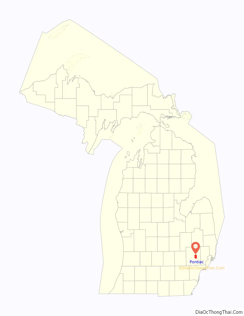
| State: | Michigan |
| County: | Oakland County |
| Incorporated: | 1837 (village) 1861 (city) |
| Elevation: | 922 ft (281 m) |
| Land Area: | 19.89 sq mi (51.50 km²) |
| Water Area: | 0.37 sq mi (0.95 km²) |
| Population Density: | 3,098.11/sq mi (1,196.16/km²) |
| Area code: | 248 and 947 |
| FIPS code: | 2665440 |
| GNISfeature ID: | 0635224 |
Online Interactive Map
Click on ![]() to view map in "full screen" mode.
to view map in "full screen" mode.
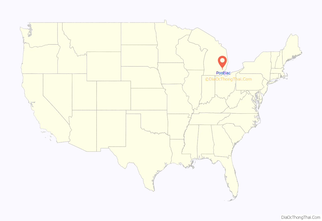
Pontiac location map. Where is Pontiac city?
History
Present-day Pontiac, Michigan was traversed for thousands of years by indigenous peoples due to the confluence of the Saginaw Trail and the Nottawassippi River; the river’s indigenous name was replaced with the Clinton River name by settlers coming from New York State where DeWitt Clinton served as Governor. The Saginaw Trail was an important land trail route for indigenous peoples that ran from the Saginaw Bay in Michigan to the Detroit River in present-day Detroit.
Early European expeditions into the land north of Detroit described the area as having “extreme sterility and barrenness”. Developments and exploration were soon to prove that report false.
The first European-American settlers arrived in what is now the city of Pontiac in 1818. They followed the Saginaw Trail north from Detroit and determined the settlement should be where the trail and the river crossed. Two years later the fledgling settlement was designated as the county seat for Oakland County, due in part to the Michigan Territorial Governor Lewis Cass being receptive to the lobbying of The Pontiac Company’s members that their recently acquired property was ideal for the county seat location.
The Pontiac Company, consisting of 15 members and chaired by Solomon Sibley of Detroit, comprised the first landowners in Pontiac. Sibley, along with Stephen Mack and Shubael Conant, Pontiac Company members, also formed the partnership Mack, Conant & Sibley to develop a town. Solomon and his wife Sarah Sibley largely financed construction of the first buildings. While Solomon was the first chair of the Pontiac Company, for two years Sarah Sibley was the most active as the go-between with settlers at Pontiac. Solomon Sibley was constantly traveling as a Territorial Congressman and later a Territorial Supreme Court judge. The Sibley-Hoyt house, thought to be one of the first structures in Pontiac, is preserved by its private owner.
In the 1820s Elizabeth Denison, an unmarried, free black woman, worked for the Sibleys. They helped her buy land in Pontiac in 1825. Stephen Mack, agent for the Pontiac Company, signed the deed at the request of the Sibleys, conveying 48.5 acres to Elizabeth Denison. She is believed to be the first black woman to purchase land in the new territory of Michigan.
In 1837 Pontiac became a village, the same year that Michigan gained statehood. The town had been named after the noted Ottawa Indian war chief who had his headquarters in the area decades before, during the resistance to European-American encroachment. Founded on the Clinton River, Pontiac was Michigan’s first inland settlement. Rivers were critical to settlements as transportation ways, in addition to providing water and, later, power.
The village was incorporated by the legislature as a city in 1861. From the beginning, Pontiac’s central location served it well. It attracted professional people, including doctors and lawyers, and soon became a center of industry. Woolen and grist mills made use of the Clinton River as a power source.
Abundant natural resources led to the establishment of several carriage manufacturing companies, all of which were thriving at the turn of the 20th century. One of the largest carriage manufacturing companies in Pontiac of that era was the O.J. Beaudette Wagon Works, which made bodies for carriages and then transitioned to manufacturing bodies for automobiles. At that time, the first self-propelled vehicles were introduced. Pontiac quickly became a capital of the new automotive industry.
Throughout the 1910s and 1920s, Pontiac had tremendous growth in its population and size as tens of thousands of prospective autoworkers moved here from the South to work in its GM auto assembly plants at Pontiac Assembly. African Americans came in the Great Migration, seeking work, education, and the chance to vote and escape the oppression of Jim Crow in the South.
As the small “horseless carriage” manufacturers became consolidated under the mantle of the General Motors Corporation, Pontiac grew as the industry grew. It also suffered the same setbacks as other cities during the Great Depression years of the 1930s. The buildup of the defense industry and conversion of the automotive industry to war demands increased the need for labor. Pontiac was a pivotal concentration of wartime production for the United States in World War II. Among many other vehicles and weapons, Pontiac facilities produced thousands of GMC trucks, Oerlikon anti-aircraft guns, naval torpedoes, tank axles, amphibious vehicles, and munitions.
The first postwar years after World War II were a time of prosperity, and continued migration of African Americans to the city in the second wave of the Great Migration, but the city changed as suburbs were developed and people commuted by car to work. The more established residents moved out to buy newer housing being built in the suburbs, draining off business and resulting in vacancies downtown. Racist policies and racial animus toward the growing African American population was also an important factor, and until the mid-1960s with the enactment of Fair Housing ordinances, most of the properties in Pontiac neighborhoods contained racially restrictive covenants in the deeds.
In order to prevent flooding, Pontiac confined the Clinton River in concrete through the downtown in 1963. Changing ideas about urban living in the early 21st century prompted the city to study uncovering the river to create a waterfront community in the city.
In late 1966, Pontiac-born real estate developer A. Alfred Taubman tried to build a large-scale shopping mall on vacant downtown land (where the Phoenix Center now stands). It was unsuccessful. Pontiac resident C. Don Davidson and his University of Detroit architectural class created a more comprehensive plan for development to benefit the city and the entire region around it. In 1969, the city of Pontiac adopted the Pontiac Plan as the official plan for rebuilding the vacant area of the downtown district.
In 1965, Davidson overheard news that the Detroit Lions were seeking a new football stadium in Southeast Michigan. Professor Davidson and city leaders made a push to develop a new multi-purpose stadium, which was built and became known as the Silverdome. Construction began on the 80,000-seat stadium in 1972 and it opened in 1975 as the Pontiac Metropolitan Stadium.
This was a part of Davidson’s vision for Pontiac. Besides becoming the new home stadium of the NFL’s Detroit Lions, NBA’s Detroit Pistons and USFL’s Michigan Panthers, the arena hosted such events as the 1979 NBA All-Star Game, the 1982 Super Bowl XVI game between the San Francisco 49ers and Cincinnati Bengals, and four matches of soccer’s 1994 World Cup.
On August 30, 1971, ten school buses were destroyed in a bombing during white resistance to a federal court order to desegregate the city’s public schools.
Construction began in the 1970s on an urban renewal project known as the “Pontiac Plan”. The initial phase of this plan included the Phoenix Center, three office buildings, a transportation center, and a high-rise residential complex. The remainder of the plan was never completed. The city has struggled with declining population since 1980, due to industrial restructuring and the loss of jobs, especially in the automotive industry.
Emergency financial manager
From 2009 through 2013, Pontiac was under the oversight of an Emergency Financial Manager appointed by the state government. The Emergency Manager was authorized to make day-to-day executive and financial municipal decisions. The position was not subject to the usual checks and balances, nor to election. The first and second managers, Fred Leeb and Michael Stampfler, were appointed by Michigan Governor Jennifer Granholm. The third manager was Louis Schimmel, who was appointed by Governor Rick Snyder.
In order to balance the budget, state-appointed emergency managers drastically revised labor union contracts with the city, sold off city assets such as parking meters, and privatized most public services. The Oakland County Sheriff’s Office handles all police (saving $2 million a year) and nearby Waterford township has responsibility for fire protection (saving $3 million). Pontiac sold its water treatment plant for $55 million, and outsources garbage collection, animal control, vital records and street maintenance. Many people working in City Hall are employed by contractors. The city payroll has declined from 600 to 50 employees. The Silverdome Stadium, once valued at $22 million, was sold for $583,000 (it would end up being demolished in December 2017). The emergency managers reduced the city’s annual spending to $36 million from $57 million, and erased almost all of its long-term debt.
In August 2013, Schimmel resigned as Emergency Financial Manager. Schimmel now serves as part of the four-member Transition Advisory Board for the city. Other members of the board include Deputy Oakland County Executive Bob Daddow, Rochester Hills Finance Director Keith Sawdon, and Ed Karyzno, administrator of the Michigan Department of Treasury’s Office of Financial Responsibility.
In July 2012, Mayor Leon Jukowski and Emergency Financial Manager Louis Schimmel announced plans to demolish the Phoenix Center. Its vacancy rates were high, and the city did not want to continue the high maintenance costs. New thinking about downtown was to re-emphasize the street grid; the city wanted to reconnect Saginaw Street to the downtown area. Owners of the connecting Ottawa Towers filed an injunction, claiming the demolition would devalue their property and result in lost parking. In December 2012, a judge granted an injunction for the Ottawa Towers on an “expedited calendar”, which prevented the demolition of the Phoenix Center for the time being.
In 2010, city leaders and business owners had launched “The Rise of The Phoenix” initiative. This plan was intended to attract businesses interested in downtown retail space. The applicants selected would be given free rent in exchange for multi-year leases (two years or more) as well as one year of free parking in city lots. Some 52 new businesses were recruited to locate in downtown Pontiac, bringing new life to the city. Plans for the development of mixed-use and loft flats in downtown were announced in September 2011 by the Michigan Economic Growth Authority (MEGA). MEGA estimates the development could generate $20.4 million in new investment and create up to 107 permanent full-time jobs in downtown. The development was to be supported by a state tax break.
On January 26, 2012, West Construction Services began the renovation and restoration of the former Sears building for the Lafayette Place Lofts, the largest construction investment in Downtown Pontiac in approximately 30 years. The 80,000-square-foot (7,400 m) project is a Leadership in Energy and Environmental Design (LEED) certified residential and commercial mixed-use development: it will have 46 new urban rental lofts, a fresh food grocery store and café, and an Anytime Fitness center. Construction was completed during 2012, and the lofts and market opened in December of that year. 10 West Lofts, another development in the area, will bring more residents to downtown Pontiac.
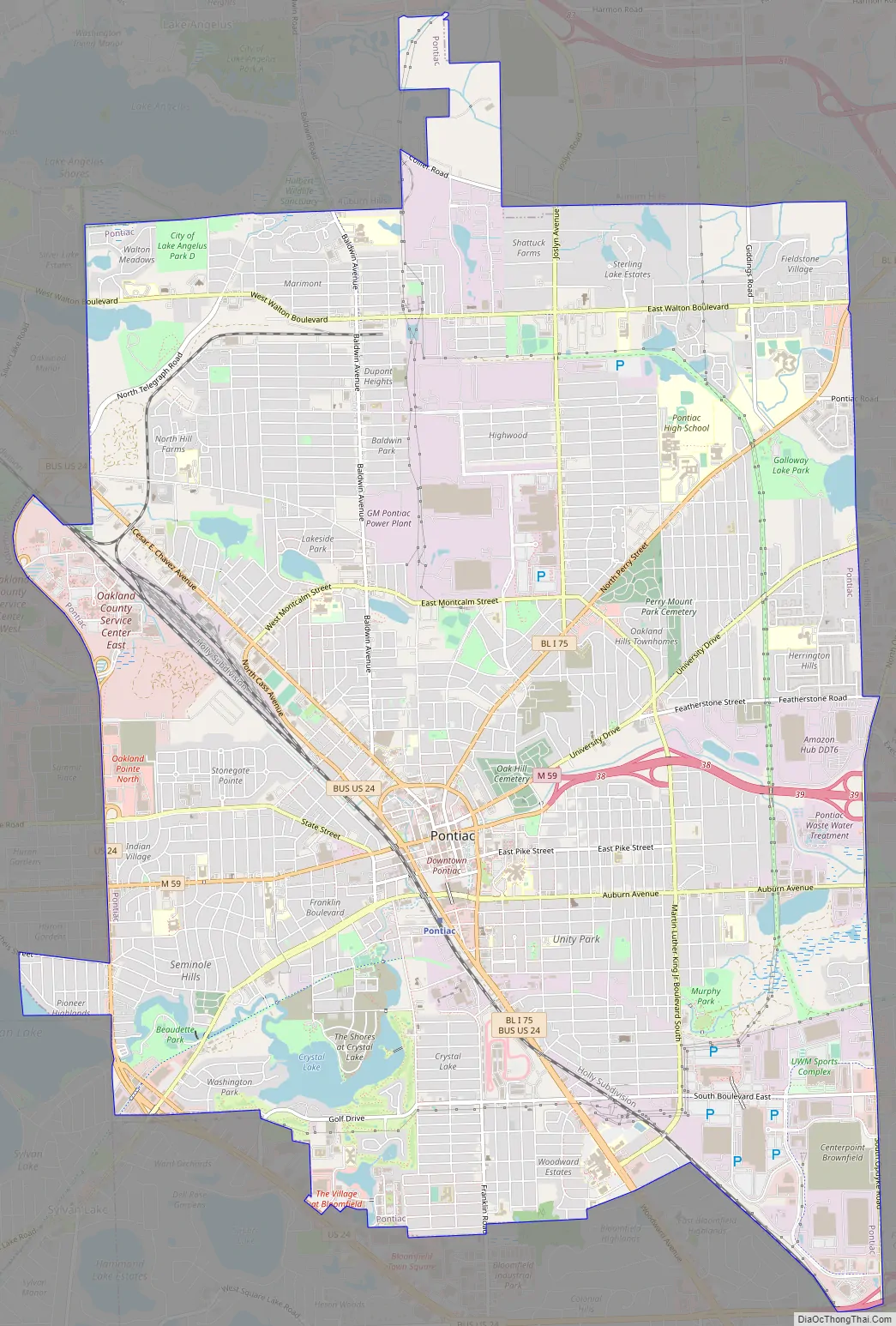
Pontiac Road Map
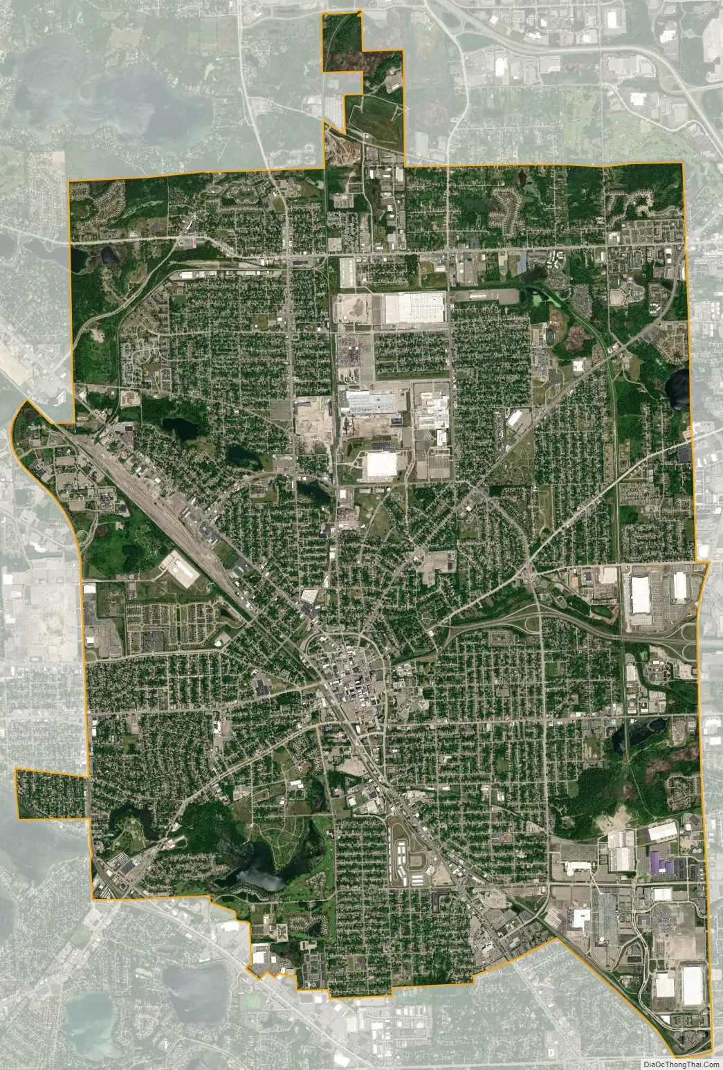
Pontiac city Satellite Map
Geography
According to the United States Census Bureau, the city has a total area of 20.29 square miles (52.55 km), of which 19.97 square miles (51.72 km) is land and 0.32 square miles (0.83 km) (1.58%) is water.
Pontiac is bounded by the city of Auburn Hills to the east and north, the city of Lake Angelus to the north, Waterford Township to the west, and Bloomfield Township to the south.
The former Pontiac Township included what are now the cities of Pontiac, Lake Angelus, and Auburn Hills. The last remaining portion of the township incorporated as the city of Auburn Hills in 1983. Although the township no longer exists as a civil entity, it is still used as a survey township for land use purposes.
See also
Map of Michigan State and its subdivision:- Alcona
- Alger
- Allegan
- Alpena
- Antrim
- Arenac
- Baraga
- Barry
- Bay
- Benzie
- Berrien
- Branch
- Calhoun
- Cass
- Charlevoix
- Cheboygan
- Chippewa
- Clare
- Clinton
- Crawford
- Delta
- Dickinson
- Eaton
- Emmet
- Genesee
- Gladwin
- Gogebic
- Grand Traverse
- Gratiot
- Hillsdale
- Houghton
- Huron
- Ingham
- Ionia
- Iosco
- Iron
- Isabella
- Jackson
- Kalamazoo
- Kalkaska
- Kent
- Keweenaw
- Lake
- Lake Hurron
- Lake Michigan
- Lake St. Clair
- Lake Superior
- Lapeer
- Leelanau
- Lenawee
- Livingston
- Luce
- Mackinac
- Macomb
- Manistee
- Marquette
- Mason
- Mecosta
- Menominee
- Midland
- Missaukee
- Monroe
- Montcalm
- Montmorency
- Muskegon
- Newaygo
- Oakland
- Oceana
- Ogemaw
- Ontonagon
- Osceola
- Oscoda
- Otsego
- Ottawa
- Presque Isle
- Roscommon
- Saginaw
- Saint Clair
- Saint Joseph
- Sanilac
- Schoolcraft
- Shiawassee
- Tuscola
- Van Buren
- Washtenaw
- Wayne
- Wexford
- Alabama
- Alaska
- Arizona
- Arkansas
- California
- Colorado
- Connecticut
- Delaware
- District of Columbia
- Florida
- Georgia
- Hawaii
- Idaho
- Illinois
- Indiana
- Iowa
- Kansas
- Kentucky
- Louisiana
- Maine
- Maryland
- Massachusetts
- Michigan
- Minnesota
- Mississippi
- Missouri
- Montana
- Nebraska
- Nevada
- New Hampshire
- New Jersey
- New Mexico
- New York
- North Carolina
- North Dakota
- Ohio
- Oklahoma
- Oregon
- Pennsylvania
- Rhode Island
- South Carolina
- South Dakota
- Tennessee
- Texas
- Utah
- Vermont
- Virginia
- Washington
- West Virginia
- Wisconsin
- Wyoming


