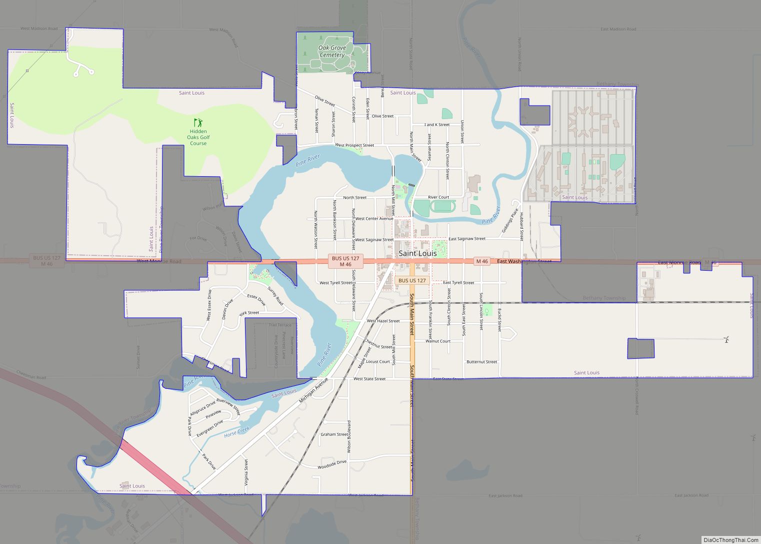
Map of St. Johns city, Michigan

Map of St. Johns city, Michigan

St. Johns or Saint Johns is the largest city and county seat of Clinton County in the U.S. state of Michigan. The population was 7,698 at the 2020 census. St. Johns is located in the north of Clinton County, surrounded by Bingham Township (although the two are administered independently). St. Johns is about 18 miles … Read more

Map of St. James CDP, Michigan

Map of St. James CDP, Michigan

St. James is an unincorporated community and census-designated place (CDP) in Charlevoix County in the U.S. state of Michigan. The population of the CDP was 145 at the 2020 census. The community is located within St. James Township. Located on the northern coast of Beaver Island in Lake Michigan, St. James was the county seat … Read more

Map of St. Ignace city

Map of St. Ignace city

St. Ignace (/ˈɪɡnəs/ IHG-nəss) is a city in the U.S. state of Michigan and the county seat of Mackinac County. The city had a population of 2,452 at the 2010 census. St. Ignace Township is located just to the north of the city, but the two are administered autonomously. St. Ignace is located along Lake … Read more

Map of Sterling village, Michigan

Map of Sterling village, Michigan

Sterling is a village in Arenac County in the U.S. state of Michigan. The population was 530 at the 2010 census. The village is located within Deep River Township. Sterling village overview: Name: Sterling village LSAD Code: 47 LSAD Description: village (suffix) State: Michigan County: Arenac County Elevation: 748 ft (228 m) Total Area: 0.98 sq mi (2.54 km²) Land … Read more

Map of Stephenson city

Map of Stephenson city

Stephenson is a city in Menominee County in the U.S. state of Michigan. The population was 862 at the 2010 census. The city is surrounded by Stephenson Township but is administered autonomously. It is part of the Marinette, WI–MI Micropolitan Statistical Area. Stephenson city overview: Name: Stephenson city LSAD Code: 25 LSAD Description: city (suffix) … Read more

Map of Stanwood village, Michigan

Map of Stanwood village, Michigan

Stanwood is a village in Mecosta County of the U.S. state of Michigan. The population was 211 at the 2010 census. The village is within Mecosta Township. Stanwood holds the record for the hottest recorded temperature in the state of Michigan along with Mio when it reached 112 °F (44 °C) on July 13, 1936. … Read more

Map of Stanton city, Michigan

Map of Stanton city, Michigan

Stanton is a city in the U.S. state of Michigan. The population was 1,417 at the 2010 census. It is the county seat of Montcalm County. It is located at the corners of four townships and incorporates land from each: Day Township to the northeast, Evergreen Township to the southeast, Sidney Township to the southwest, … Read more

Map of Standish city, Michigan

Map of Standish city, Michigan

Standish is a city in the U.S. state of Michigan. The population was 1,458 at the 2020 census. It is the county seat of Arenac County. Standish city overview: Name: Standish city LSAD Code: 25 LSAD Description: city (suffix) State: Michigan County: Arenac County Incorporated: 1893 (village)1903 (city) Elevation: 623 ft (190 m) Total Area: 2.18 sq mi (5.64 km²) … Read more

Map of Sturgis city, Michigan

Map of Sturgis city, Michigan

Sturgis is a city in St. Joseph County in the U.S. state of Michigan. The population was 10,994 at the 2010 census. The city is located at the northeast corner of Sturgis Township and at the intersection of US 12 and M-66. Sturgis is just north of the Michigan–Indiana border and the I-80/90 Indiana Toll … Read more

Map of Stronach CDP

Map of Stronach CDP

Stronach is an unincorporated community and census-designated place in Stronach Township, Manistee County, Michigan, United States. Its population was 162 as of the 2010 census. The community is located at the southeast end of Lake Manistee. Stronach CDP overview: Name: Stronach CDP LSAD Code: 57 LSAD Description: CDP (suffix) State: Michigan County: Manistee County Elevation: … Read more

Map of Stony Point CDP

Map of Stony Point CDP, Michigan

Stony Point is an unincorporated community and census-designated place (CDP) in Monroe County in the U.S. state of Michigan. The population was 1,784 at the 2020 census. The CDP is located within Frenchtown Charter Township. Stony Point CDP overview: Name: Stony Point CDP LSAD Code: 57 LSAD Description: CDP (suffix) State: Michigan County: Monroe County … Read more

Map of Stockbridge village, Michigan

Map of Stockbridge village, Michigan

Stockbridge is a village in Ingham County in the U.S. state of Michigan. It is located within Stockbridge Township about 36 miles (58 km) southeast from downtown Lansing. The population was 1,218 at the 2010 census. Stockbridge village overview: Name: Stockbridge village LSAD Code: 47 LSAD Description: village (suffix) State: Michigan County: Ingham County Elevation: 932 ft … Read more