Map of Westport city, Minnesota

Map of Westport city, Minnesota

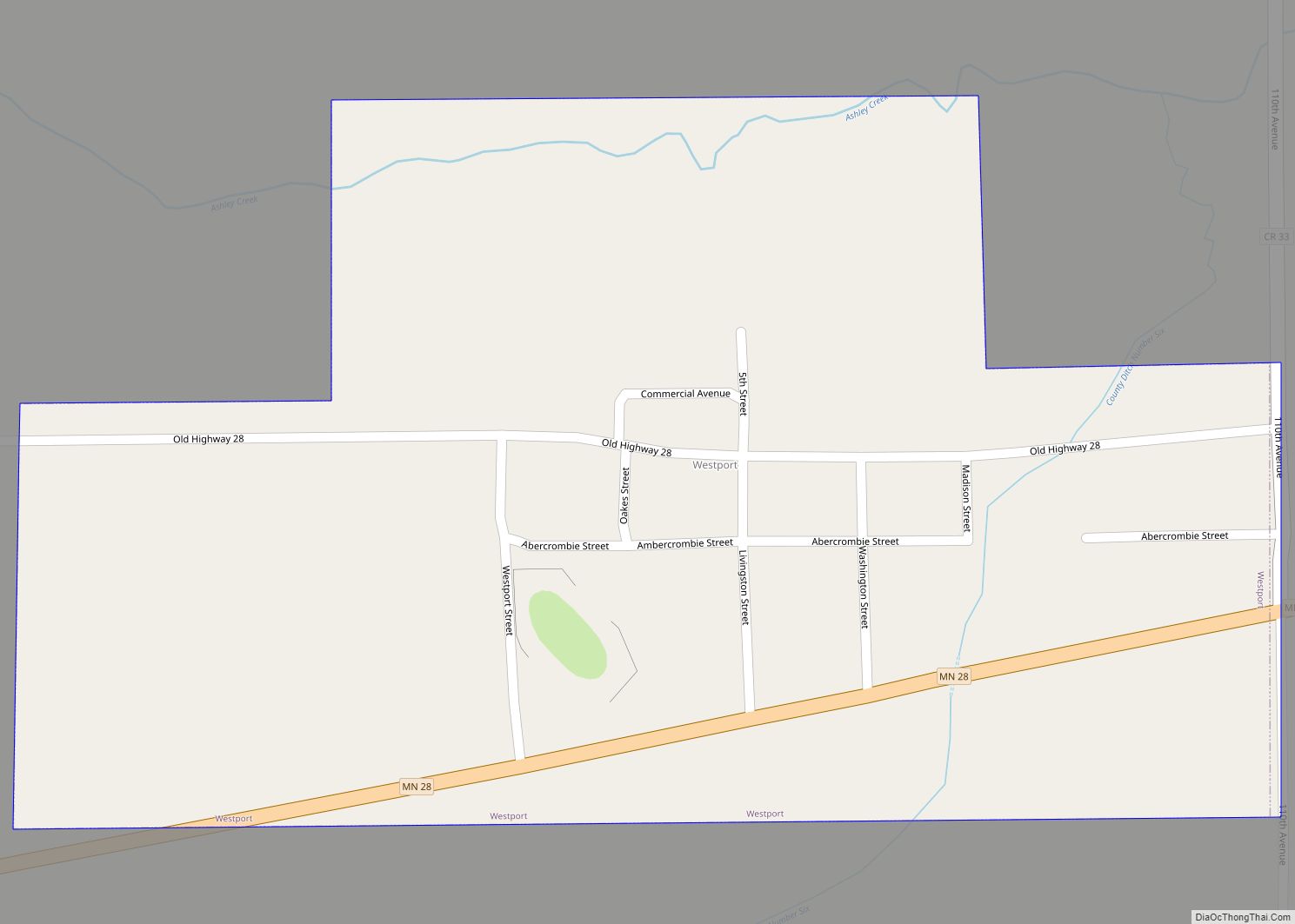
Westport is a city in Pope County, Minnesota, United States. The population was 44 at the 2020 census. Westport city overview: Name: Westport city LSAD Code: 25 LSAD Description: city (suffix) State: Minnesota County: Pope County Founded: 1866 Incorporated: March 13, 1926 Elevation: 1,332 ft (406 m) Total Area: 0.26 sq mi (0.68 km²) Land Area: 0.26 sq mi (0.68 km²) Water Area: … Read more

Map of White Earth CDP

Map of White Earth CDP, Minnesota

White Earth is a census-designated place (CDP) in Becker County, Minnesota, United States. The population was 580 at the 2010 census. White Earth was named after the White Earth Indian Reservation, and that took its name from the White Earth Lake. White Earth CDP overview: Name: White Earth CDP LSAD Code: 57 LSAD Description: CDP … Read more

Map of White Bear Lake city

Map of White Bear Lake city

White Bear Lake is a city in Ramsey County in the state of Minnesota, United States. A small portion of the city also extends into Washington County. The population was 23,769 at the 2010 census. The city is located on White Bear Lake, one of the largest lakes in the Minneapolis–Saint Paul metropolitan area. White … Read more

Map of Whipholt CDP

Map of Whipholt CDP

Whipholt is an unincorporated community and census-designated place (CDP) in Pine Lake Township, Cass County, Minnesota, United States, along Leech Lake. Its population was 99 as of the 2010 census. The community is located along State Highway 200 (MN 200) near Pine Lake Road. Whipholt is 13 miles east of Walker. Whipholt CDP overview: Name: … Read more

Map of Williams city, Minnesota

Map of Williams city, Minnesota

Williams is a city in Lake of the Woods County, Minnesota, United States. The population was 191 at the 2010 census. Williams city overview: Name: Williams city LSAD Code: 25 LSAD Description: city (suffix) State: Minnesota County: Lake of the Woods County Elevation: 1,152 ft (351 m) Total Area: 0.98 sq mi (2.53 km²) Land Area: 0.98 sq mi (2.53 km²) Water Area: … Read more

Map of Willernie city

Map of Willernie city

Willernie is a city in Washington County, Minnesota, United States. It is bordered on all sides by the city of Mahtomedi. The population was 507 at the 2010 census. Willernie city overview: Name: Willernie city LSAD Code: 25 LSAD Description: city (suffix) State: Minnesota County: Washington County Elevation: 968 ft (295 m) Total Area: 0.13 sq mi (0.34 km²) Land … Read more

Map of Wilder city, Minnesota

Map of Wilder city, Minnesota

Wilder is a city in Jackson County, Minnesota, United States. The population was 60 at the 2010 census. Wilder city overview: Name: Wilder city LSAD Code: 25 LSAD Description: city (suffix) State: Minnesota County: Jackson County Elevation: 1,476 ft (450 m) Total Area: 0.79 sq mi (2.04 km²) Land Area: 0.79 sq mi (2.04 km²) Water Area: 0.00 sq mi (0.00 km²) Total Population: 62 Population … Read more

Map of Willmar city

Map of Willmar city

Willmar is a city in, and the county seat of, Kandiyohi County, Minnesota, United States. The population was 21,015 at the 2020 census. Willmar city overview: Name: Willmar city LSAD Code: 25 LSAD Description: city (suffix) State: Minnesota County: Kandiyohi County Founded: 1871 Elevation: 1,145 ft (349 m) Total Area: 15.58 sq mi (40.35 km²) Land Area: 14.23 sq mi (36.86 km²) Water … Read more

Map of Wilmont city

Map of Wilmont city

Wilmont is a city in Nobles County, Minnesota, United States. The population was 339 at the 2010 census. Wilmont city overview: Name: Wilmont city LSAD Code: 25 LSAD Description: city (suffix) State: Minnesota County: Nobles County Elevation: 1,726 ft (526 m) Total Area: 0.69 sq mi (1.80 km²) Land Area: 0.69 sq mi (1.80 km²) Water Area: 0.00 sq mi (0.00 km²) Total Population: 332 Population … Read more

Map of Willow River city

Map of Willow River city

Willow River is a city in Pine County, Minnesota, United States, at the confluence of the Kettle and Willow Rivers. The population was 415 at the 2010 census. Interstate 35, County Road 43, and County 61 (Cross Street) are three of the main routes in the community. Willow River city overview: Name: Willow River city … Read more

Map of Winger city

Map of Winger city

Winger is a city in Polk County, Minnesota, United States. It is part of the Grand Forks, ND–MN Metropolitan Statistical Area. The population was 174 at the 2020 census. Winger city overview: Name: Winger city LSAD Code: 25 LSAD Description: city (suffix) State: Minnesota County: Polk County Elevation: 1,234 ft (376 m) Total Area: 0.32 sq mi (0.84 km²) Land … Read more

Map of Windom city, Minnesota

Map of Windom city, Minnesota

Windom is a city in Cottonwood County, Minnesota, United States. The population was 4,646 at the 2010 census. It is the county seat of Cottonwood County and is situated in the Coteau des Prairies. Although it is a small, rural farming community, Windom is host to several parks including a disc golf course at Mayflower … Read more