Map of Foxworth CDP

Map of Foxworth CDP

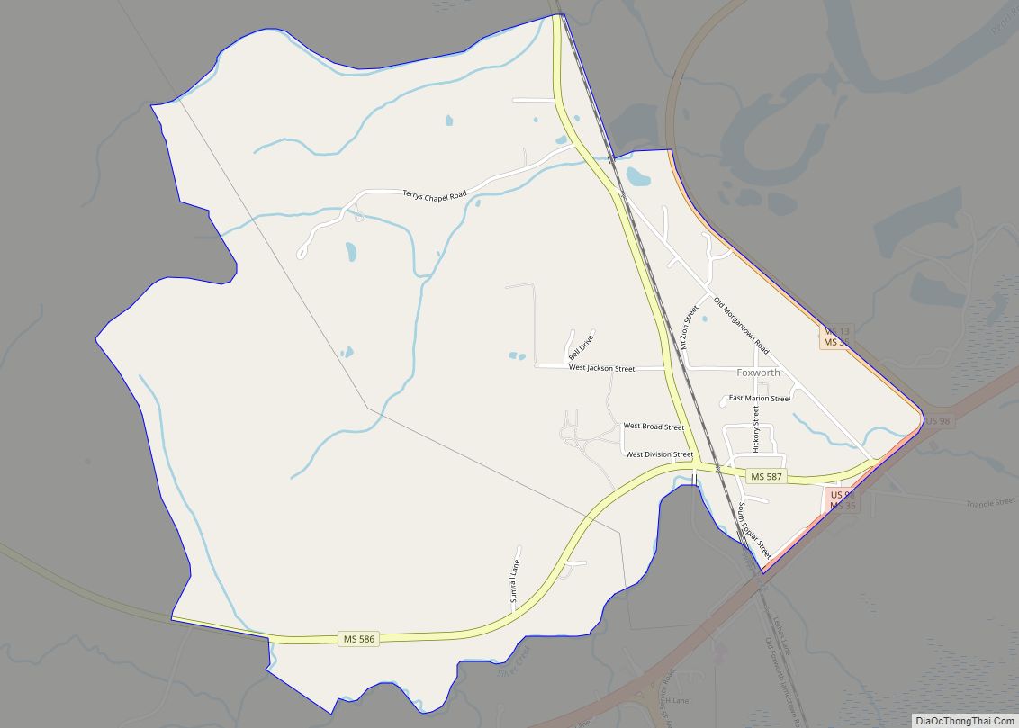
Foxworth is an unincorporated community and Census-designated place in Marion County, Mississippi. It is located near the intersection of U.S. Route 98 and Mississippi Highway 35, approximately three miles southwest of Columbia along the west bank of the Pearl River. The community is named after Frank A. Foxworth, one of the first white settlers in … Read more

Map of Glendora village, Mississippi

Map of Glendora village, Mississippi

Glendora is a village in Tallahatchie County, Mississippi. The population was 285 at the 2000 census. Glendora village overview: Name: Glendora village LSAD Code: 47 LSAD Description: village (suffix) State: Mississippi County: Tallahatchie County Elevation: 148 ft (45 m) Total Area: 0.14 sq mi (0.37 km²) Land Area: 0.14 sq mi (0.37 km²) Water Area: 0.00 sq mi (0.00 km²) Total Population: 154 Population Density: 1,069.44/sq mi … Read more

Map of Glendale CDP, Mississippi

Map of Glendale CDP, Mississippi

Glendale is an unincorporated community and census-designated place (CDP) located in Forrest County, Mississippi, United States. Glendale is approximately 3.5 miles (5.6 km) north of Hattiesburg on Mississippi Highway 42 and a part of the Hattiesburg, Mississippi Metropolitan Statistical Area. As of the 2020 census, Glendale had a population of 1,681. Glendale CDP overview: Name: Glendale … Read more

Map of Glen town

Map of Glen town

Glen is a town in Alcorn County, Mississippi. The population was 382 at the 2020 census, down from 412 at the 2010 census. Glen town overview: Name: Glen town LSAD Code: 43 LSAD Description: town (suffix) State: Mississippi County: Alcorn County Total Area: 4.67 sq mi (12.09 km²) Land Area: 4.66 sq mi (12.07 km²) Water Area: 0.01 sq mi (0.02 km²) Total Population: … Read more

Map of Georgetown town, Mississippi

Map of Georgetown town, Mississippi

Georgetown is a town in Copiah County, Mississippi, United States. The population was 286 at the 2010 census. With its eastern border formed by the Pearl River, it is part of the Jackson Metropolitan Statistical Area. Two sites near Georgetown are listed on the National Register of Historic Places: the Highway 28 bridge over the … Read more

Map of Gautier city

Map of Gautier city

Gautier (/ˈɡoʊʃeɪ/ GOH-SHAY) is a city in Jackson County, Mississippi, United States, along the Gulf of Mexico west of Pascagoula. It is part of the Pascagoula Metropolitan Statistical Area. The population was 18,572 at the 2010 census, up from 11,681 at the 2000 census. In 2002, Gautier had annexed land more than doubling its area. … Read more

Map of Gloster town, Mississippi

Map of Gloster town, Mississippi

Gloster is a town in central Amite County, Mississippi, United States. The population was 897 at the 2020 census. Gloster town overview: Name: Gloster town LSAD Code: 43 LSAD Description: town (suffix) State: Mississippi County: Amite County Elevation: 423 ft (129 m) Total Area: 1.82 sq mi (4.72 km²) Land Area: 1.82 sq mi (4.72 km²) Water Area: 0.00 sq mi (0.00 km²) Total Population: 897 … Read more

Map of Greenwood city, Mississippi

Map of Greenwood city, Mississippi

Greenwood is a city in and the county seat of Leflore County, Mississippi, United States, located at the eastern edge of the Mississippi Delta region, approximately 96 miles north of the state capital, Jackson, and 130 miles south of the riverport of Memphis, Tennessee. It was a center of cotton planter culture in the 19th … Read more

Map of Greenville city, Mississippi

Map of Greenville city, Mississippi

Greenville is a city in and the county seat of Washington County, Mississippi, United States. The population was 34,400 at the 2010 census. It is located in the area of historic cotton plantations and culture known as the Mississippi Delta. Greenville city overview: Name: Greenville city LSAD Code: 25 LSAD Description: city (suffix) State: Mississippi … Read more

Map of Goodman town, Mississippi

Map of Goodman town, Mississippi

Goodman is a town in southeastern Holmes County, Mississippi, United States. Per the 2020 census, the population was 1,258. Goodman town overview: Name: Goodman town LSAD Code: 43 LSAD Description: town (suffix) State: Mississippi County: Holmes County Elevation: 266 ft (81 m) Total Area: 0.83 sq mi (2.15 km²) Land Area: 0.82 sq mi (2.13 km²) Water Area: 0.01 sq mi (0.02 km²) Total Population: 1,258 … Read more

Map of Golden town, Mississippi

Map of Golden town, Mississippi

Golden is a town in Tishomingo County, Mississippi, United States. The population was 191 at the 2010 census. The village’s current mayor is Davy Ginn. Golden town overview: Name: Golden town LSAD Code: 43 LSAD Description: town (suffix) State: Mississippi County: Tishomingo County Elevation: 554 ft (169 m) Total Area: 0.58 sq mi (1.50 km²) Land Area: 0.58 sq mi (1.50 km²) Water … Read more

Map of Guntown town

Map of Guntown town

Guntown is a city in Lee County, Mississippi, located in the northern part of the Tupelo micropolitan area. The population was 2,410 at the 2020 Census. Guntown town overview: Name: Guntown town LSAD Code: 43 LSAD Description: town (suffix) State: Mississippi County: Lee County Founded: April 13, 1866 (1866-04-13) Incorporated: February 16, 1867 (1867-02-16) Elevation: 400 ft (122 m) Total Area: 4.67 sq mi (12.10 km²) … Read more