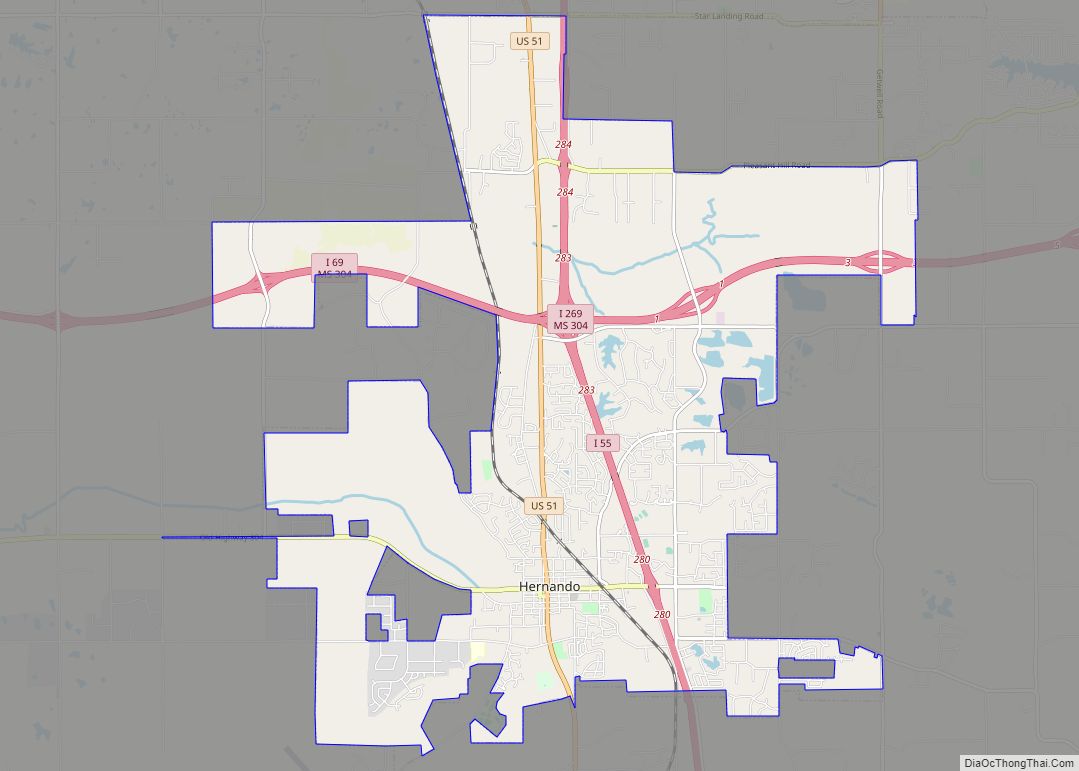
Map of Hide-A-Way Lake CDP
Hide-A-Way Lake is an unincorporated community and census-designated place in Pearl River County, Mississippi, United States. Its population was 2,065 as of the 2020 census. Hide-A-Way Lake CDP overview: Name: Hide-A-Way Lake CDP LSAD Code: 57 LSAD Description: CDP (suffix) State: Mississippi County: Pearl River County Elevation: 102 ft (31 m) Total Area: 1.825 sq mi (4.73 km²) Land Area: ... Read more
Map of Hide-A-Way Lake CDP
Map of Hickory town, Mississippi
Hickory is a town in Newton County, Mississippi. The population was 530 at the 2010 census. The town is named after Andrew Jackson, nicknamed “Old Hickory,” who passed through the area on his way to fight the Battle of New Orleans during the War of 1812. Hickory town overview: Name: Hickory town LSAD Code: 43 ... Read more
Map of Hickory town, Mississippi
Map of Horn Lake city
Horn Lake is a city in DeSoto County, Mississippi, United States. It is located 1.2 mi (1.9 km) south of Memphis, Tennessee. As of the 2010 U.S. Census, the population of Horn Lake was 26,066, up from 14,099 in 2000. Horn Lake city overview: Name: Horn Lake city LSAD Code: 25 LSAD Description: city (suffix) State: Mississippi ... Read more
Map of Horn Lake city
Map of Holly Springs city, Mississippi
Holly Springs is a city in, and the county seat of, Marshall County, Mississippi, United States, near the border with Tennessee to the north. Along with the Mississippi Delta, in the 19th century, the area was developed by European Americans for cotton plantations. After the Civil War, many freedmen continued to work in agriculture as ... Read more
Map of Holly Springs city, Mississippi
Map of Hollandale city, Mississippi
Hollandale is a city in Washington County, Mississippi, United States. The population was 2,323 at the 2020 census. Deer Creek flows through Hollandale, and the Leroy Percy State Park is west of the city along Mississippi Highway 12. The Hollandale Municipal Airport is northeast of the city. A 2008 study by the University of North ... Read more
Map of Hollandale city, Mississippi
Map of Holcomb CDP, Mississippi
Holcomb is an unincorporated community and census-designated place (CDP) in Grenada County, Mississippi, United States. It is part of the Grenada Micropolitan Statistical Area. As of the 2010 census the community had a population of 600. Holcomb has a post office with the ZIP Code of 38940. Holcomb CDP overview: Name: Holcomb CDP LSAD Code: ... Read more
Map of Holcomb CDP, Mississippi
Map of Hillsboro CDP, Mississippi
Hillsboro is an unincorporated community and census-designated place (CDP) in Scott County, Mississippi, United States. Its population was 1,130 as of the 2010 census. Hillsboro has a post office with ZIP code 39087. Hillsboro CDP overview: Name: Hillsboro CDP LSAD Code: 57 LSAD Description: CDP (suffix) State: Mississippi County: Scott County Elevation: 436 ft (133 m) Total ... Read more
Map of Hillsboro CDP, Mississippi
Map of Isola town
Isola is a town in Humphreys County, Mississippi, United States, on the banks of Lake Dawson. The population was 713 at the 2010 census, down from 768 at the 2000 census. The name is derived from “isolation”, due to the town’s remote location when it was founded. Isola town overview: Name: Isola town LSAD Code: ... Read more
Map of Isola town
Map of Inverness town, Mississippi
Inverness is a town in Sunflower County, Mississippi, United States. The population was 1,019 at the 2010 census. As the town had the largest cotton gin in the Delta, it served as a gathering place for farmers from the region when they brought their cotton for processing. The town was heavily damaged by a tornado ... Read more
Map of Inverness town, Mississippi
Map of Indianola city, Mississippi
Indianola is a U.S. city in Sunflower County, Mississippi, in the Mississippi Delta. The population was 10,683 at the 2010 census. It is the county seat of Sunflower County. Indianola city overview: Name: Indianola city LSAD Code: 25 LSAD Description: city (suffix) State: Mississippi County: Sunflower County Total Area: 8.66 sq mi (22.42 km²) Land Area: 8.57 sq mi (22.20 km²) ... Read more
Map of Indianola city, Mississippi
Map of Hurley CDP, Mississippi
Hurley is an unincorporated community and census-designated place (CDP) in Jackson County, Mississippi, United States. It is part of the Pascagoula Metropolitan Statistical Area. The population was 1,551 at the 2010 census, up from 985 at the 2000 census. Hurley CDP overview: Name: Hurley CDP LSAD Code: 57 LSAD Description: CDP (suffix) State: Mississippi County: ... Read more
Map of Hurley CDP, Mississippi
Map of Houston city, Mississippi
Houston is a city in and one of two county seats of Chickasaw County, in northern Mississippi, United States. The population was 3,623 at the 2010 census. Houston city overview: Name: Houston city LSAD Code: 25 LSAD Description: city (suffix) State: Mississippi County: Chickasaw County Elevation: 354 ft (108 m) Total Area: 7.40 sq mi (19.15 km²) Land Area: 7.38 sq mi ... Read more
Map of Houston city, Mississippi