Map of Canalou city

Map of Canalou city

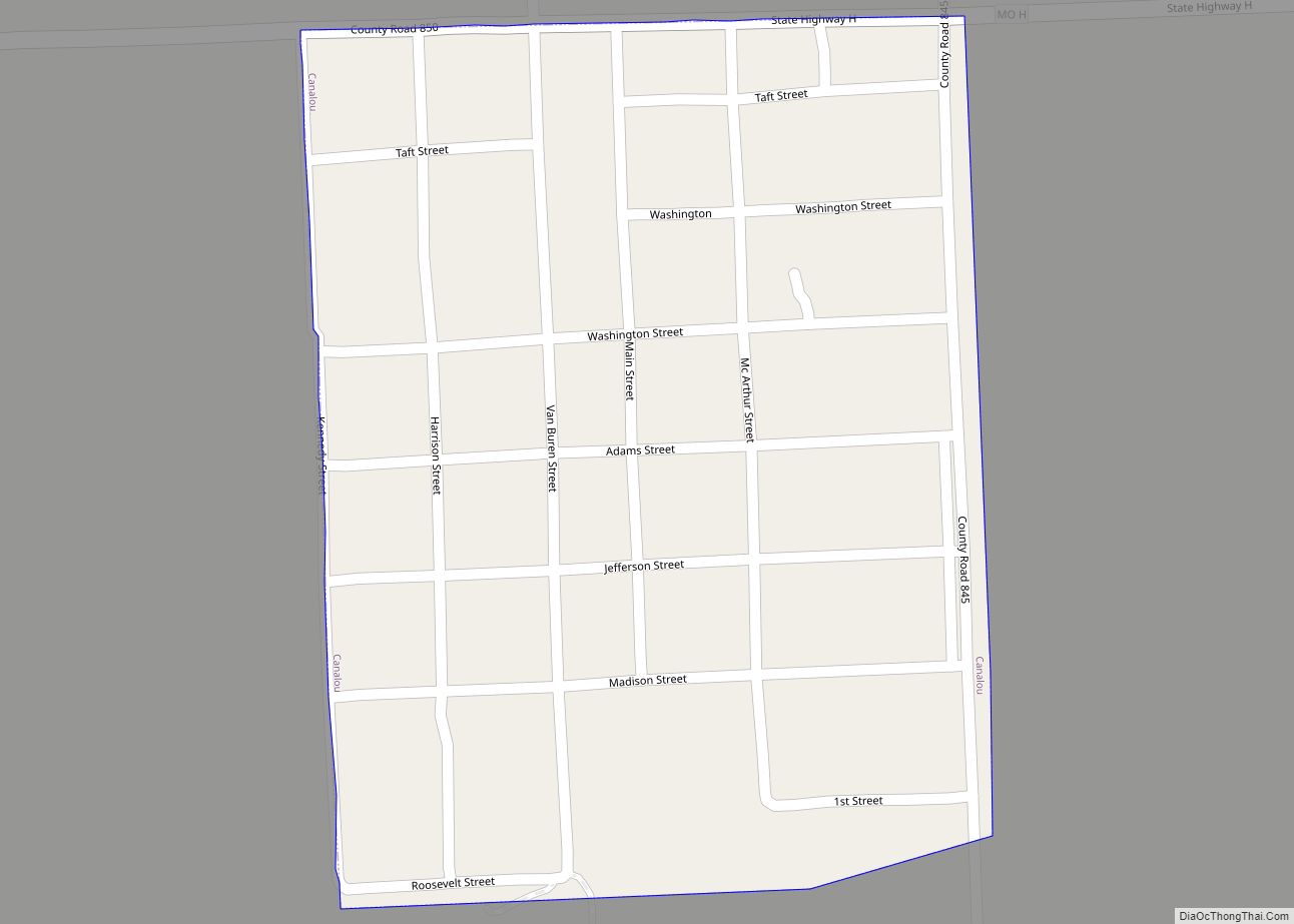
Canalou is a city in New Madrid County, Missouri, United States. The population was 338 at the 2010 census. The ZIP code is 63828. Canalou city overview: Name: Canalou city LSAD Code: 25 LSAD Description: city (suffix) State: Missouri County: New Madrid County Elevation: 289 ft (88 m) Total Area: 0.20 sq mi (0.52 km²) Land Area: 0.20 sq mi (0.52 km²) Water … Read more

Map of Campbell city, Missouri

Map of Campbell city, Missouri

Campbell is a city in northern Dunklin County, Missouri, United States. The population was 1,992 at the 2010 census. Campbell city overview: Name: Campbell city LSAD Code: 25 LSAD Description: city (suffix) State: Missouri County: Dunklin County Elevation: 315 ft (96 m) Total Area: 1.40 sq mi (3.64 km²) Land Area: 1.40 sq mi (3.64 km²) Water Area: 0.00 sq mi (0.00 km²) Total Population: 1,605 … Read more

Map of Cardwell city

Map of Cardwell city, Missouri

Cardwell is a city in southwest Dunklin County, Missouri, United States. The population was 713 at the 2010 census. The current Mayor of Cardwell is Brandon Cupp and the current aldermen are Harvey Beasley, Mike Clark, and Chuck Walls. Cardwell city overview: Name: Cardwell city LSAD Code: 25 LSAD Description: city (suffix) State: Missouri County: … Read more

Map of Cape Girardeau city

Map of Cape Girardeau city

Cape Girardeau (/dʒɪˈrɑːrdoʊ/ jirr-AR-doh, French: Cap-Girardeau [kap ʒiʁaʁdo] (listen); colloquially referred to as “Cape”) is a city in Cape Girardeau and Scott Counties in the U.S. state of Missouri. At the 2020 census, the population was 39,540. The city is one of two principal cities of the Cape Girardeau-Jackson, MO-IL Metropolitan Statistical Area, which encompasses … Read more

Map of Carl Junction city

Map of Carl Junction city

Carl Junction is a city in Jasper County, Missouri, United States. The population was 8,143 at the 2020 census. Carl Junction city overview: Name: Carl Junction city LSAD Code: 25 LSAD Description: city (suffix) State: Missouri County: Jasper County Elevation: 856 ft (261 m) Total Area: 5.61 sq mi (14.52 km²) Land Area: 5.47 sq mi (14.17 km²) Water Area: 0.13 sq mi (0.34 km²) Total … Read more

Map of Carthage city, Missouri

Map of Carthage city, Missouri

Carthage is a city in Jasper County, Missouri, United States. The population was 15,522 as of the 2020 census. It is the county seat of Jasper County and is nicknamed “America’s Maple Leaf City.” Carthage city overview: Name: Carthage city LSAD Code: 25 LSAD Description: city (suffix) State: Missouri County: Jasper County Elevation: 1,040 ft (320 m) … Read more

Map of Carterville city, Missouri

Map of Carterville city, Missouri

Carterville is a city in Jasper County, Missouri, United States. The population was 1,855 at the 2020 census. It is part of the Joplin, Missouri Metropolitan Statistical Area. Carterville city overview: Name: Carterville city LSAD Code: 25 LSAD Description: city (suffix) State: Missouri County: Jasper County Elevation: 1,001 ft (305 m) Total Area: 2.61 sq mi (6.75 km²) Land Area: … Read more

Map of Carrollton city, Missouri

Map of Carrollton city, Missouri

Carrollton is a city in Carroll County, Missouri, United States. Carrollton won the 2005 All-America City Award, given out annually by the National Civic League. The population was 3,514 at the 2020 census. Carrollton is the county seat of Carroll County. Carrollton city overview: Name: Carrollton city LSAD Code: 25 LSAD Description: city (suffix) State: … Read more

Map of Cassville city

Map of Cassville city, Missouri

Cassville is a city in Flat Creek Township, Barry County, Missouri, United States. According to the 2020 census, the population of Cassville was 3,190. Cassville is one of the primary markets and job centers for an estimated 14,000 people living in the surrounding area. It is the county seat of Barry County. Cassville city overview: … Read more

Map of Carytown city

Map of Carytown city

Carytown is a village in Jasper County, Missouri, United States. The population was 287 at the 2020 census. It is part of the Joplin, Missouri Metropolitan Statistical Area. Carytown city overview: Name: Carytown city LSAD Code: 25 LSAD Description: city (suffix) State: Missouri County: Jasper County Elevation: 951 ft (290 m) Total Area: 14.43 sq mi (37.38 km²) Land Area: … Read more

Map of Caruthersville city

Map of Caruthersville city

Caruthersville is a city in and the county seat of Pemiscot County, Missouri, United States, located along the Mississippi River in the Bootheel region of the state’s far southeast. The population was 5,562, according to the 2020 census. Caruthersville city overview: Name: Caruthersville city LSAD Code: 25 LSAD Description: city (suffix) State: Missouri County: Pemiscot … Read more

Map of Cave town

Map of Cave town

Cave is a populated place in Lincoln County, Missouri, United States. The population was 5 at the 2010 census. With a 2020 population of 5, it is the 939th largest city in Missouri and the 19481st largest city in the United States. Cave is currently declining at a rate of 0.00% annually and its population … Read more