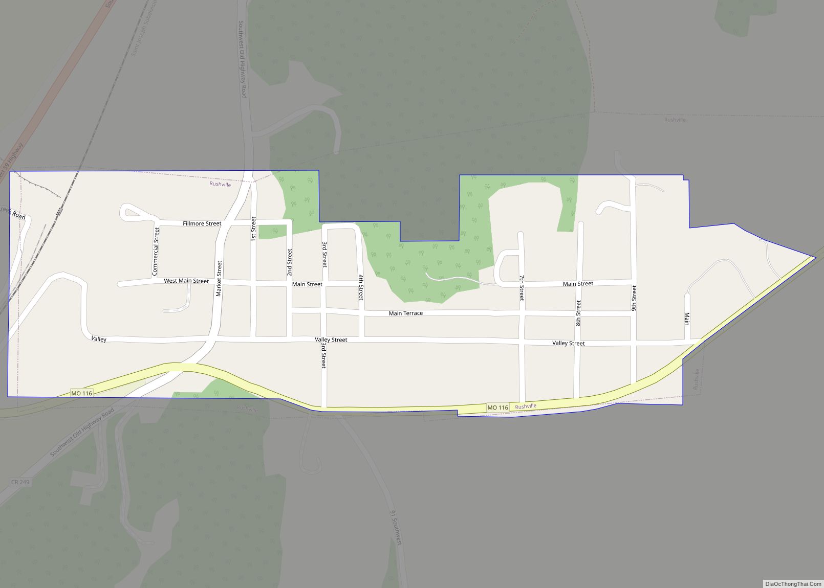
Map of Rush Hill village

Map of Rush Hill village

Rush Hill is a village in Audrain County, Missouri, United States. The population was 151 at the 2010 census. Rush Hill village overview: Name: Rush Hill village LSAD Code: 47 LSAD Description: village (suffix) State: Missouri County: Audrain County Elevation: 787 ft (240 m) Total Area: 0.18 sq mi (0.47 km²) Land Area: 0.18 sq mi (0.46 km²) Water Area: 0.00 sq mi (0.00 km²) Total … Read more

Map of Russellville city, Missouri

Map of Russellville city, Missouri

Russellville is a city in Cole County, Missouri, United States. The population was 778 at the 2020 census. It is part of the Jefferson City, Missouri Metropolitan Statistical Area. Russellville city overview: Name: Russellville city LSAD Code: 25 LSAD Description: city (suffix) State: Missouri County: Cole County Founded: 1838 Incorporated: 1848 Elevation: 873 ft (266 m) Total … Read more

Map of Saginaw village, Missouri

Map of Saginaw village, Missouri

Saginaw is a village in Newton County, Missouri, United States. The population was 297 at the 2010 census. It is part of the Joplin, Missouri Metropolitan Statistical Area. Saginaw village overview: Name: Saginaw village LSAD Code: 47 LSAD Description: village (suffix) State: Missouri County: Newton County Elevation: 1,001 ft (305 m) Total Area: 0.83 sq mi (2.14 km²) Land Area: … Read more

Map of Saddlebrooke village, Missouri

Map of Saddlebrooke village, Missouri

Saddlebrooke is a village located in southern Christian County, Missouri, on U.S. Route 65. A small portion of the village extends into Taney County. It is a master-planned community which incorporated in 2003. The population was 309 at the time of the 2020 census. The Christian County portion of the village is part of the … Read more

Map of Rutledge town, Missouri

Map of Rutledge town, Missouri

Rutledge is a village in Scotland County, Missouri, United States. As of the 2020 census, its population was 86. The surrounding area is also the home to three intentional communities: Dancing Rabbit Ecovillage, a growing ecovillage on 280 acres (1.1 km) of rolling land, Sandhill Farm in unincorporated Sand Hill, Missouri, and Red Earth Farms. A … Read more

Map of Sappington CDP

Map of Sappington CDP

Sappington is an unincorporated census-designated place in St. Louis County, Missouri, United States. The population was 7,995 at the 2020 census. Sappington CDP overview: Name: Sappington CDP LSAD Code: 57 LSAD Description: CDP (suffix) State: Missouri County: St. Louis County Elevation: 617 ft (188 m) Total Area: 2.39 sq mi (6.20 km²) Land Area: 2.39 sq mi (6.20 km²) Water Area: 0.00 sq mi (0.00 km²) … Read more

Map of Salisbury city, Missouri

Map of Salisbury city, Missouri

Salisbury is a city in Chariton County, Missouri, United States. The population was 1,563 at the 2020 census. Salisbury city overview: Name: Salisbury city LSAD Code: 25 LSAD Description: city (suffix) State: Missouri County: Chariton County Founded: April 1, 1867 Elevation: 742 ft (226 m) Total Area: 1.34 sq mi (3.47 km²) Land Area: 1.34 sq mi (3.47 km²) Water Area: 0.00 sq mi (0.00 km²) … Read more

Map of Salem city, Missouri

Map of Salem city, Missouri

Salem is the county seat of Dent County, Missouri, United States. The population was 4,608 at the 2020 census, which allows Salem to become a Class 3 city in Missouri; however, the city has chosen to remain a Class 4 city under Missouri Revised Statutes. Salem is located a few miles north of the Ozark … Read more

Map of Schell City city

Map of Schell City

Schell City is a city in northeast Vernon County, Missouri, United States. The population was 249 at the 2010 census. Schell City overview: Name: Schell City LSAD Code: 25 LSAD Description: city (suffix) State: Missouri County: Vernon County Founded: 1871 Incorporated: 1871 Elevation: 768 ft (234 m) Total Area: 0.63 sq mi (1.63 km²) Land Area: 0.62 sq mi (1.61 km²) Water Area: … Read more

Map of Savannah city, Missouri

Map of Savannah city, Missouri

Savannah is a city and county seat of Andrew County, Missouri, United States. The population was 5,069 at the 2020 census. Savannah city overview: Name: Savannah city LSAD Code: 25 LSAD Description: city (suffix) State: Missouri County: Andrew County Elevation: 1,076 ft (328 m) Total Area: 3.26 sq mi (8.45 km²) Land Area: 3.25 sq mi (8.42 km²) Water Area: 0.01 sq mi (0.04 km²) Total … Read more

Map of Sarcoxie city

Map of Sarcoxie city

Sarcoxie is a city in Jasper County, Missouri, United States. The population was 1,406 at the 2020 census. It is part of the Joplin, Missouri Metropolitan Statistical Area. Sarcoxie city overview: Name: Sarcoxie city LSAD Code: 25 LSAD Description: city (suffix) State: Missouri County: Jasper County Elevation: 1,171 ft (357 m) Total Area: 1.42 sq mi (3.66 km²) Land Area: … Read more

Map of Sedalia city, Missouri

Map of Sedalia city, Missouri

Sedalia is a city located approximately 30 miles (50 kilometers) south of the Missouri River and, as the county seat of Pettis County, Missouri, United States, it is the principal city of the Sedalia Micropolitan Statistical Area. As of the 2010 census, the city had a total population of 21,387. Sedalia is also the location … Read more