Sedalia is a city located approximately 30 miles (50 kilometers) south of the Missouri River and, as the county seat of Pettis County, Missouri, United States, it is the principal city of the Sedalia Micropolitan Statistical Area. As of the 2010 census, the city had a total population of 21,387. Sedalia is also the location of the Missouri State Fair and the Scott Joplin Ragtime Festival. U.S. Routes 50 and 65 intersect in the city.
| Name: | Sedalia city |
|---|---|
| LSAD Code: | 25 |
| LSAD Description: | city (suffix) |
| State: | Missouri |
| County: | Pettis County |
| Founded: | 1857 |
| Elevation: | 899 ft (274 m) |
| Total Area: | 14.32 sq mi (37.09 km²) |
| Land Area: | 14.29 sq mi (37.00 km²) |
| Water Area: | 0.03 sq mi (0.09 km²) |
| Total Population: | 21,725 |
| Population Density: | 1,520.72/sq mi (587.16/km²) |
| ZIP code: | 65301-65302 |
| Area code: | 660 |
| FIPS code: | 2966440 |
| GNISfeature ID: | 2396567 |
| Website: | www.cityofsedalia.com |
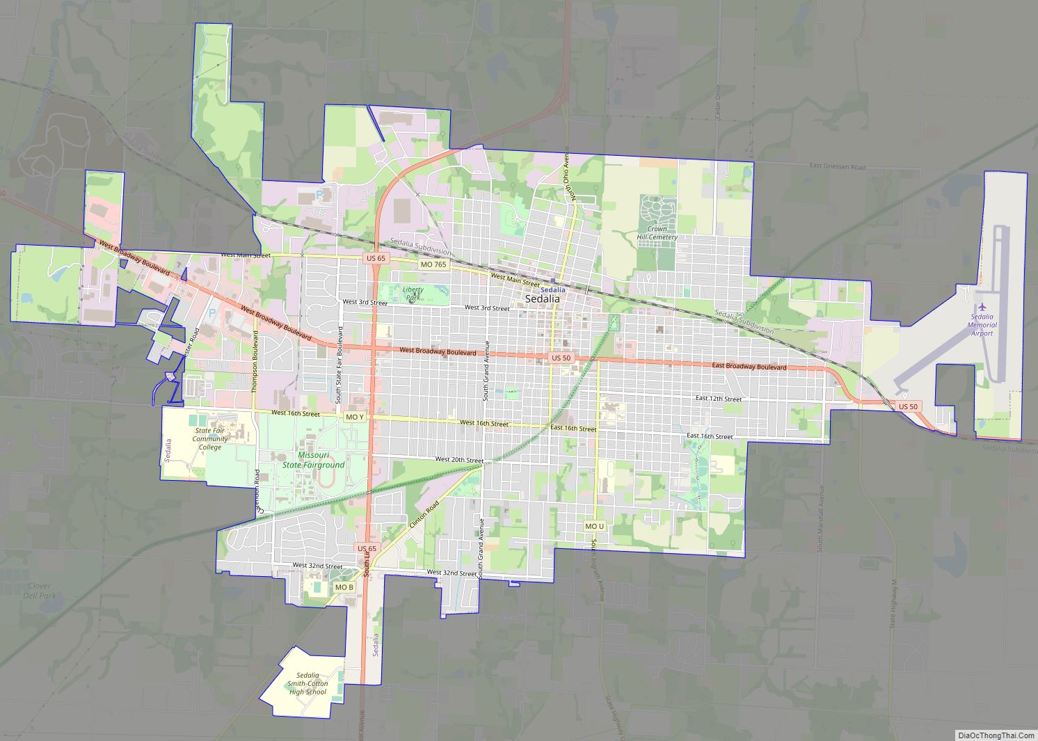
Online Interactive Map
Click on ![]() to view map in "full screen" mode.
to view map in "full screen" mode.
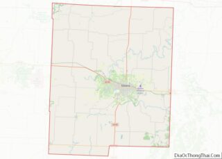
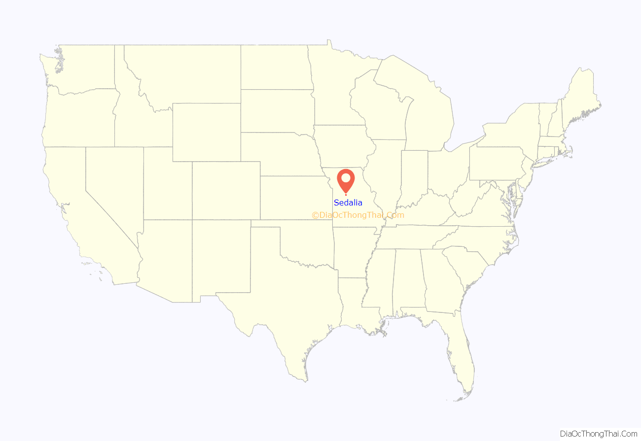
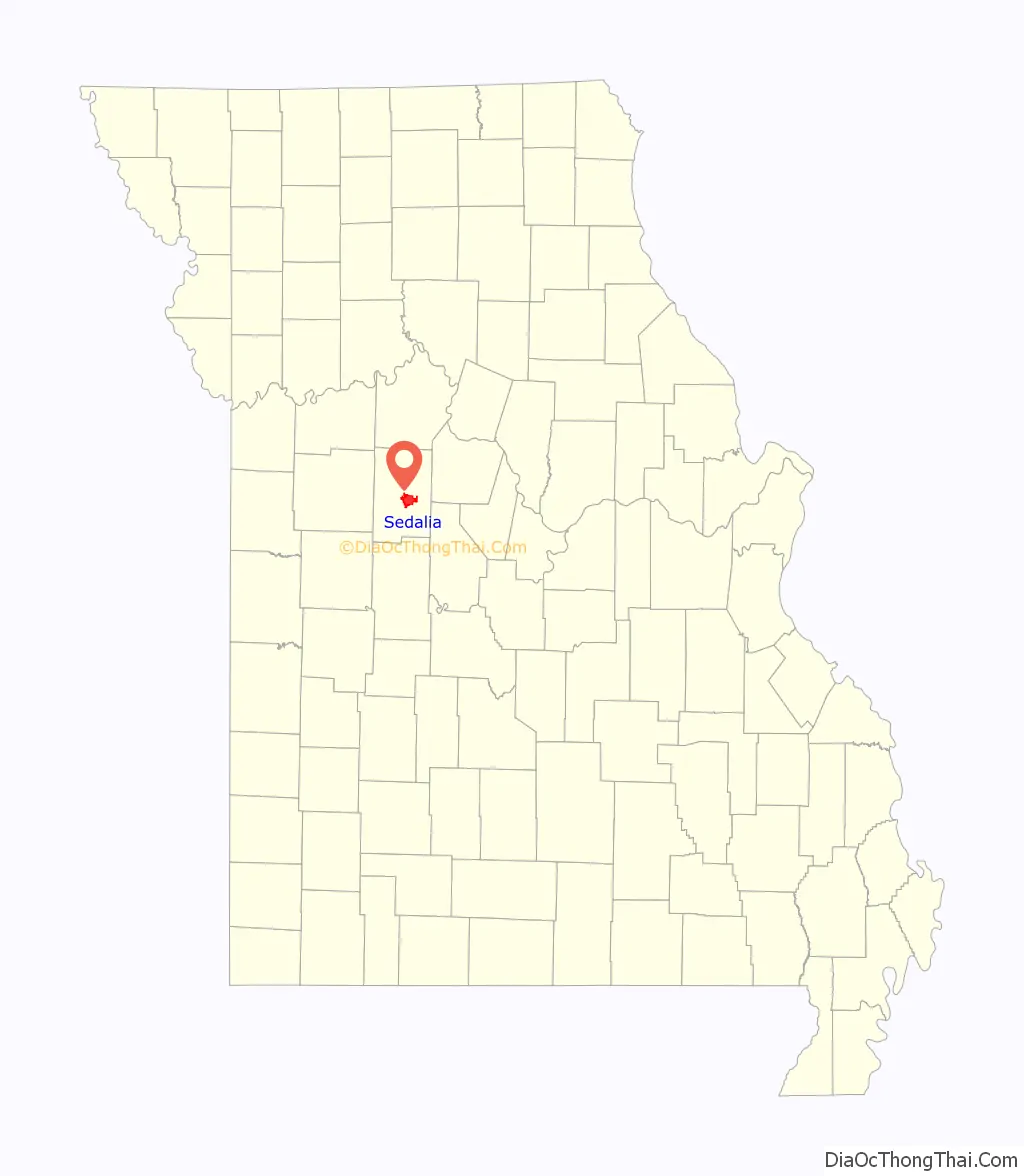
Sedalia location map. Where is Sedalia city?
History
Indigenous peoples lived along the Missouri River and its tributaries for thousands of years before European contact. Historians believe the entire area around Sedalia was long occupied by the Osage (among historical American Indian tribes). When the land was first settled by European Americans, bands of Shawnee, who had migrated from east of the Mississippi River, lived in the vicinity of Sedalia.
Until the city was incorporated in 1860 as Sedalia, it had existed only “on paper” from November 30, 1857, to October 16, 1860. According to local lore, the town council changed the name from Sedville to Sedalia in part because “towns that end in -ville don’t amount to anything.” (Lawrence Ditton Sr.). Here is another account:
The area that became the European-American city of Sedalia was founded by General George Rappeen Smith (1804–1879), who also founded nearby Smithton, Missouri. He filed plans for the official record on November 30, 1857, and gave the area the name Sedville. The original plat included the land from today’s Missouri Pacific Railroad south to Third Street.
The version jointly filed by General Smith and David W. Bouldin on October 16, 1860, displayed the city extending from Clay Street to the north and to Smith Street (today’s Third Street) in the south, and from Missouri Street in the west to Washington Street in the east; and, although Smith and Bouldin predicted that the city would grow to the north, it grew in a southern direction.
Railhead
Following a victory for those proposing the “ridge route” for the railway over those advocating the “river route”, the railway reached Sedalia in January 1861. Sedalia’s early prosperity was directly related to the railroad industry. Many jobs were associated with men maintaining tracks and operating large and varied machine shops run by both the Missouri Pacific and the Missouri-Kansas-Texas Railroad lines. The Missouri-Kansas & Texas Railroad was widely known as the “KATY”, from its “K-T” stock exchange code.
Sedalia was an important railhead for the massive Texas cattle drive of 1866. It maintained stockyards to receive cattle from drives and shipping through much of the 19th century.
For nearly a century, Sedalia’s economy was tied to the railroads. By the end of the 19th century, the MK&T had numerous buildings and a wide variety of workers in the city: the MK&T shops, stockyards, roundhouse, and the hospital for employees working in the Sedalia Division were among the Katy’s properties in Sedalia.
After the KATY reduced its operations in the 20th century, its railroad right-of-way through much of Missouri was converted to a 240-mile multi-use trail. The KATY Trail is used by bikers, walkers and horseback riders. This has been the largest new trail developed in the nation among the late 20th-century federal and state “Rails to Trails” projects.
Civil War
During the Civil War, the U.S. Army had a small garrison in the area, adding to its boomtown atmosphere of accelerated development as merchants and traders attracted to the military business came to the area. In the postbellum period, two railroads were constructed connecting it to other locations, and Sedalia grew at a rapid pace, with the rough energy of travelers and cowboys. From 1866 to 1874, it was a railhead terminus for cattle drives, and stockyards occupied a large area. At the same time, the town established schools (racially segregated for white and black children), churches, and other civic amenities.
On October 15, 1864, Shelby’s Confederate cavalry brigade surrounded the Union post of Sedalia. The post commander, Colonel John D. Crawford, fled. Captain Oscar B. Queen of Company M, 7th Cavalry, Missouri State Militia, surrendered the post shortly thereafter. Missouri State Guard Brigadier-General M. Jeff Thompson subsequently paroled the prisoners of war and moved on, leaving Sedalia to itself.
Late 19th century
While the Civil War delayed development of the town in some respects, Sedalia was the terminus of the railroad for three years. Once the war was over, many of the thousands of Union soldiers who had been stationed more or less permanently at Sedalia and recognized its potential, made the choice to migrate there from their former homes in other areas. The population grew rapidly.
In the late 19th century, Sedalia was well known as a center of vice, especially prostitution, which accompanied its large floating class of railroad workers and commercial travelers. In 1877 the St. Louis Post-Dispatch called Sedalia the “Sodom and Gomorrah of the nineteenth century.” Middle-class businessmen made money off illegal prostitution as building owners and lessees; others did business with people in the industry, who banked, used lawyers, etc., in town. Residents were reluctant to raise taxes and services were provided from the fines charged to prostitutes.
In the 1870s brothels were distributed throughout the city, but in the 1890s, they became more concentrated above businesses on West Main Street, as the middle class tried to isolate less desirable elements in town. These establishments also employed musicians, particularly piano players, contributing to a thriving musical culture. It fostered the development of many artists, including the renowned ragtime composer Scott Joplin.
20th and 21st centuries
While the city attracted many commercial travelers and railroad workers, its population of married couples and families also grew. By 1900 its population of more than 15,000 made it the sixth-largest city in the state. The entrepreneurial middle class created more formal separations between its residential areas and those of working class whites and African Americans.
During World War II, the military built Sedalia Glider Base in Johnson County to the west. After the war, this facility was transferred to the Strategic Air Command. It was converted to a bomber base, the Whiteman Air Force Base, named after 2nd Lt. George A. Whiteman, an Army Air Corps pilot who was killed during the 1941 Japanese attack on Pearl Harbor. After a massive construction program, the base became the center of 150 ICBM silos and administrative offices. These were decommissioned in the 1990s.
Sedalia is home to the nation’s first sheltered workshop, which opened in 1965.
The expansion of the railroad and cattle drives in the late 19th century brought many male laborers to the rough town on the frontier. It sparked the related rise of a notorious “red light district”, with numerous prostitutes who did business with the men in saloons and brothels, which also featured musical entertainments.
As more families settled in the area, they made the culture more stable, creating institutions such as schools and churches. In the late 20th century, structural changes in the railroads meant the loss of many industrial jobs, but the city has held on to a population close to its 1960 peak while developing new bases for the economy. The city is informally known as the “Trailer Capital of the Midwest”, due to the high number of trailer manufacturers and dealers in the area.
Residents have emphasized the colorful history of the town for heritage tourism, and identified many significant historic structures for state and national recognition. Good quality retail and craft items are sold in the historic districts and buildings of the city.
According to The History of the Boy Scouts of America (William D. Murray, 1937), the first Boy Scout Troop in Missouri (and one of the first in the nation) was formed in Sedalia in 1909, a year before the national organization was officially chartered on February 8, 1910.
Tornadoes
On October 24, 2021, a EF0 tornado touched down east of Sedalia. It is the most recent tornado to strike Sedalia.
Sedalia Road Map
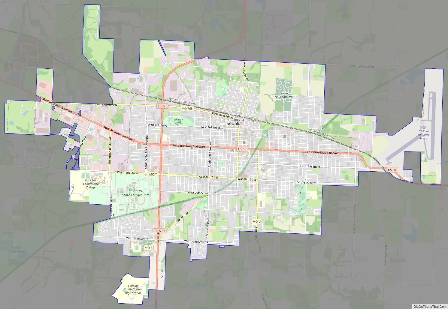
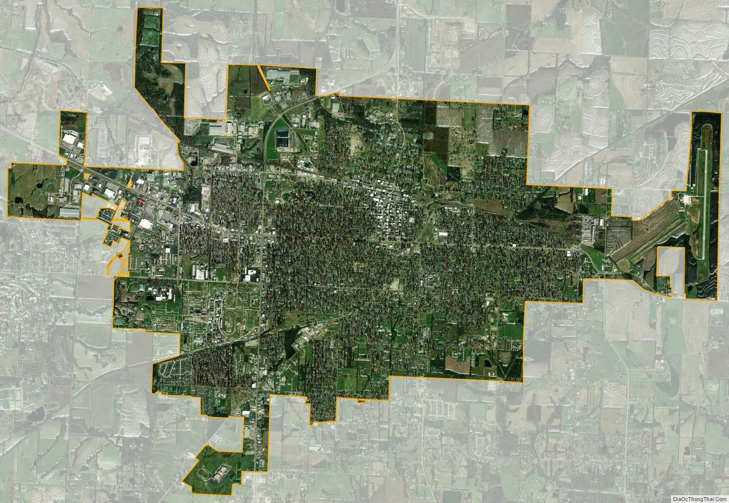
Sedalia city Satellite Map
Geography
According to the United States Census Bureau, the city has a total area of 13.32 square miles (34.50 km), of which 13.29 square miles (34.42 km) is land and 0.03 square miles (0.08 km) is water.
Climate
Sedalia has a typical temperate climate. As with most continental climates, the micropolitan area has four seasons. Springs in Sedalia are noted for their rainy days and variable temperatures. Thunderstorms are common and tornadoes occur during this time of year. Summers are usually hot and humid, with droughts occurring during several summers. Autumns are usually cool and rainy, although several days of warm weather are not uncommon. Winters are generally cold, with snow accumulating several days of the winter season. Although not as common, ice storms occur as well.
See also
Map of Missouri State and its subdivision:- Adair
- Andrew
- Atchison
- Audrain
- Barry
- Barton
- Bates
- Benton
- Bollinger
- Boone
- Buchanan
- Butler
- Caldwell
- Callaway
- Camden
- Cape Girardeau
- Carroll
- Carter
- Cass
- Cedar
- Chariton
- Christian
- Clark
- Clay
- Clinton
- Cole
- Cooper
- Crawford
- Dade
- Dallas
- Daviess
- De Kalb
- Dent
- Douglas
- Dunklin
- Franklin
- Gasconade
- Gentry
- Greene
- Grundy
- Harrison
- Henry
- Hickory
- Holt
- Howard
- Howell
- Iron
- Jackson
- Jasper
- Jefferson
- Johnson
- Knox
- Laclede
- Lafayette
- Lawrence
- Lewis
- Lincoln
- Linn
- Livingston
- Macon
- Madison
- Maries
- Marion
- McDonald
- Mercer
- Miller
- Mississippi
- Moniteau
- Monroe
- Montgomery
- Morgan
- New Madrid
- Newton
- Nodaway
- Oregon
- Osage
- Ozark
- Pemiscot
- Perry
- Pettis
- Phelps
- Pike
- Platte
- Polk
- Pulaski
- Putnam
- Ralls
- Randolph
- Ray
- Reynolds
- Ripley
- Saint Charles
- Saint Clair
- Saint Francois
- Saint Louis
- Sainte Genevieve
- Saline
- Schuyler
- Scotland
- Scott
- Shannon
- Shelby
- Stoddard
- Stone
- Sullivan
- Taney
- Texas
- Vernon
- Warren
- Washington
- Wayne
- Webster
- Worth
- Wright
- Alabama
- Alaska
- Arizona
- Arkansas
- California
- Colorado
- Connecticut
- Delaware
- District of Columbia
- Florida
- Georgia
- Hawaii
- Idaho
- Illinois
- Indiana
- Iowa
- Kansas
- Kentucky
- Louisiana
- Maine
- Maryland
- Massachusetts
- Michigan
- Minnesota
- Mississippi
- Missouri
- Montana
- Nebraska
- Nevada
- New Hampshire
- New Jersey
- New Mexico
- New York
- North Carolina
- North Dakota
- Ohio
- Oklahoma
- Oregon
- Pennsylvania
- Rhode Island
- South Carolina
- South Dakota
- Tennessee
- Texas
- Utah
- Vermont
- Virginia
- Washington
- West Virginia
- Wisconsin
- Wyoming