Map of Prospect Park borough

Map of Prospect Park borough, New Jersey

Prospect Park is a borough in Passaic County, in the U.S. state of New Jersey. As of the 2020 United States census, the borough’s population was 6,372, an increase of 507 (+8.6%) from the 2010 census count of 5,865, which in turn reflected an increase of 86 (+1.5%) from the 5,779 counted in the 2000 … Read more

Map of Ridgefield Park village

Map of Ridgefield Park village

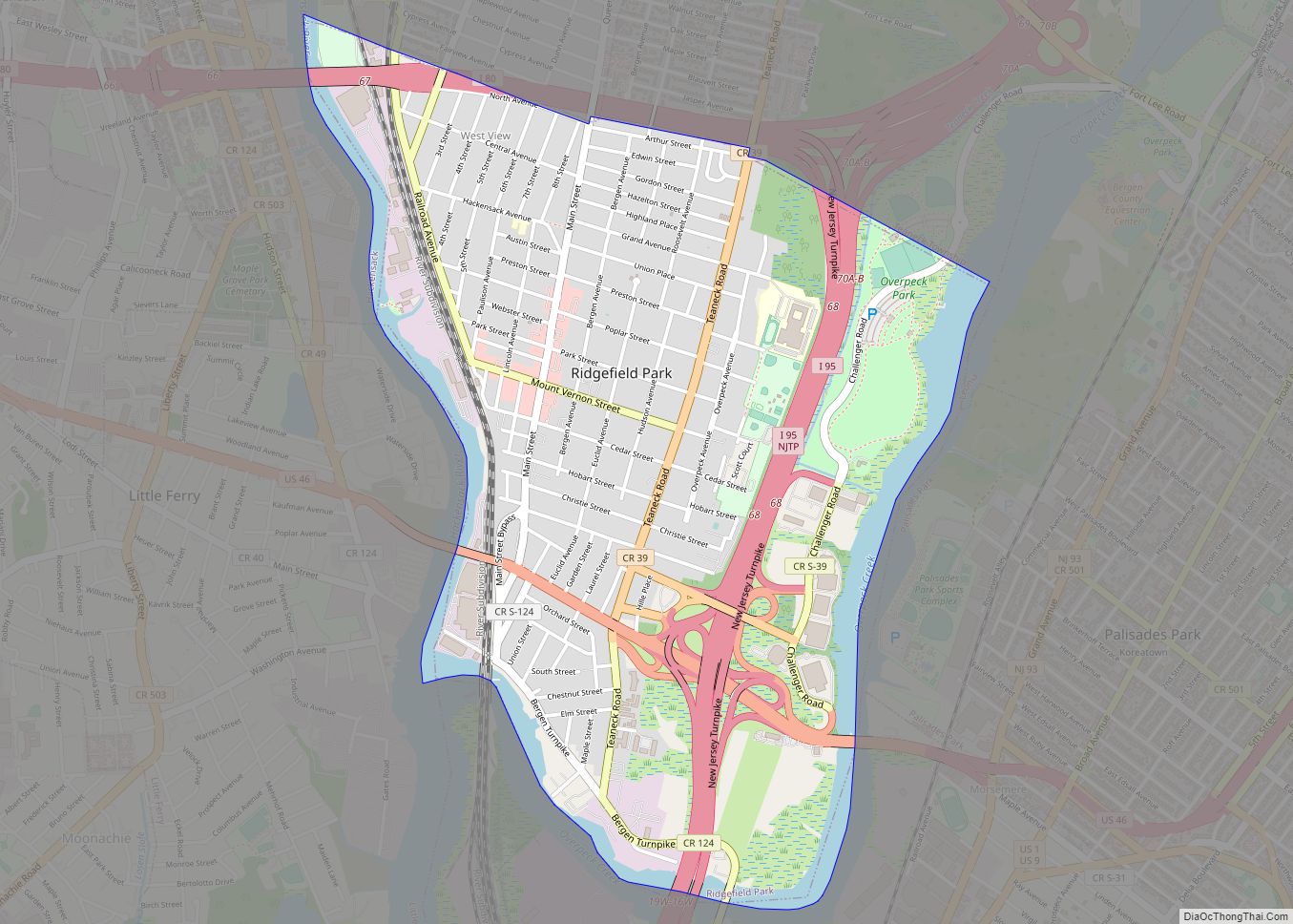
Ridgefield Park is a village in Bergen County, in the U.S. state of New Jersey. As of the 2020 United States census, the village’s population was 13,224, an increase of 495 (+3.9%) from the 2010 census count of 12,729, which in turn reflected a decline of 144 (−1.1%) from the 12,873 counted in the 2000 … Read more

Map of Richwood CDP, New Jersey

Map of Richwood CDP, New Jersey

Richwood is an unincorporated community and census-designated place (CDP) located in Gloucester County, New Jersey, United States, that is split between Harrison Township (with 3,400 of the CDP’s residents) and Mantua Township (with 59 of the total). As of the 2020 United States census, the CDP’s population was 3,577, an increase of 118 (+3.4%) from … Read more

Map of Red Bank borough

Map of Red Bank borough, New Jersey

Red Bank is a borough in Monmouth County, in the U.S. state of New Jersey. Incorporated in 1908, the community is on the Navesink River, the area’s original transportation route to the ocean and other ports. Red Bank is in the New York metropolitan area and is a commuter town of New York City. As … Read more

Map of Raritan borough, New Jersey

Map of Raritan borough, New Jersey

Raritan is a borough in Somerset County, in the U.S. state of New Jersey. As of the 2010 United States Census, the borough’s population was 6,881, reflecting an increase of 543 (+8.6%) from the 6,338 counted in the 2000 census. The borough’s name is derived from the Raritans, a Native American group of Lenape. The … Read more

Map of Ramtown CDP

Map of Ramtown CDP

Ramtown is a census-designated place and unincorporated community located within Howell Township, in Monmouth County, New Jersey, United States. As of the 2010 United States Census, the CDP’s population was 6,242. Ramtown CDP overview: Name: Ramtown CDP LSAD Code: 57 LSAD Description: CDP (suffix) State: New Jersey County: Monmouth County Elevation: 59 ft (18 m) Total Area: … Read more

Map of Ramsey borough, New Jersey

Map of Ramsey borough, New Jersey

Ramsey is a borough in Bergen County, in the U.S. state of New Jersey. It is a suburb of New York City, located 26 miles (42 km) northwest of Midtown Manhattan. As of the 2020 United States census, the borough’s population was 14,798, an increase of 325 (+2.2%) from the 2010 census count of 14,473, which … Read more

Map of Ramblewood CDP

Map of Ramblewood CDP, New Jersey

Ramblewood is an unincorporated community and census-designated place (CDP) located within Mount Laurel Township in Burlington County, New Jersey, United States. As of the 2010 United States Census, the CDP’s population was 5,907. Ramblewood CDP overview: Name: Ramblewood CDP LSAD Code: 57 LSAD Description: CDP (suffix) State: New Jersey County: Burlington County Elevation: 30 ft (9 m) … Read more

Map of Rahway city

Map of Rahway city

Rahway (/ˈrɔːweɪ/) is a city in southern Union County, in the U.S. state of New Jersey. A bedroom community of New York City, it is centrally located in the Rahway Valley region, in the New York metropolitan area. The city is 15 miles (24 km) southwest of Manhattan and 5 miles (8.0 km) west of Staten Island. … Read more

Map of Quinton CDP

Map of Quinton CDP, New Jersey

Quinton is an unincorporated community and census-designated place (CDP) located within Quinton Township, in Salem County, New Jersey, United States. As of the 2010 United States Census, the CDP’s population was 1,402. Quinton CDP and Quinton Township are not coextensive, with the CDP covering 3.7% of the 24.588 miles (39.571 km) of the township as a … Read more

Map of Riverton borough, New Jersey

Map of Riverton borough, New Jersey

Riverton is a borough located in Burlington County, in the U.S. state of New Jersey. As of the 2020 United States census, the borough’s population was 2,764, a decrease of 15 (−.5%) from the 2010 census count of 2,779, which in turn reflected an increase of 20 (+0.7%) from the 2,759 counted in the 2000 … Read more

Map of Riverdale borough, New Jersey

Map of Riverdale borough, New Jersey

Riverdale is a borough in Morris County, in the U.S. state of New Jersey. As of the 2020 United States census, the borough’s population was 4,107, an increase of 548 (+15.4%) from the 2010 census count of 3,559, which in turn reflected an increase of 1,061 (+42.5%) from the 2,498 counted at the 2000 Census. … Read more