Map of Sussex borough, New Jersey
Sussex is a borough in Sussex County, in the U.S. state of New Jersey. As of the 2020 United States census, the borough’s population was 2,024, a decrease of 106 (−5.0%) from the 2010 census count of 2,130, which in turn reflected a decline of 15 (−0.7%) from the 2,145 counted in the 2000 census. ... Read more
Map of Sussex borough, New Jersey
Map of Surf City borough, New Jersey
Surf City is a borough in Ocean County, in the U.S. state of New Jersey. As of the 2020 United States census, the borough’s population was 1,243, an increase of 38 (+3.2%) from the 2010 census count of 1,205, which in turn reflected a decline of 237 (−16.4%) from the 1,442 counted in the 2000 ... Read more
Map of Surf City borough, New Jersey
Map of Summit city, New Jersey
Summit is a city in Union County, in the U.S. state of New Jersey. The city is located on a ridge in northern-central New Jersey, within the Raritan Valley and Rahway Valley regions in the New York metropolitan area. As of the 2020 United States census, the city’s population was 22,719, an increase of 1,262 ... Read more
Map of Summit city, New Jersey
Map of Succasunna CDP
Succasunna is an unincorporated community and census-designated place (CDP) located within Roxbury Township, in Morris County, in the U.S. state of New Jersey, serving as its downtown and population center, having a population of 9,152 people as of the 2010 United States Census. Succasunna CDP overview: Name: Succasunna CDP LSAD Code: 57 LSAD Description: CDP ... Read more
Map of Succasunna CDP
Map of Strathmore CDP, New Jersey
Strathmore is an unincorporated community and census-designated place (CDP) within Aberdeen Township, in Monmouth County, New Jersey, United States. At the 2010 census, the CDP’s population was 7,258. Strathmore CDP overview: Name: Strathmore CDP LSAD Code: 57 LSAD Description: CDP (suffix) State: New Jersey County: Monmouth County Elevation: 49 ft (15 m) Total Area: 2.02 sq mi (5.23 km²) Land ... Read more
Map of Strathmore CDP, New Jersey
Map of Strathmere CDP
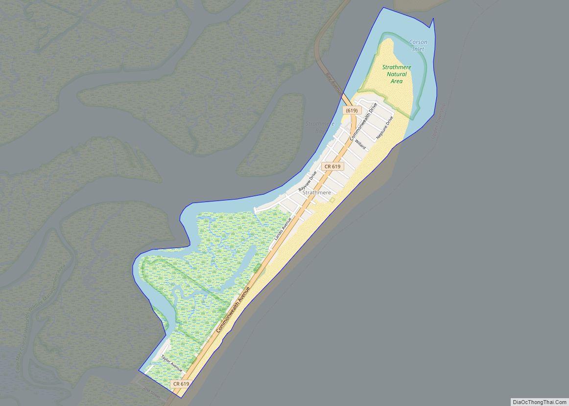
Strathmere is an unincorporated community and census-designated place (CDP) located within Upper Township in Cape May County, New Jersey, United States. As of the 2020 United States census, the CDP’s population was 137, a decrease of 21 (−13.3%) from the 158 counted at the 2010 U.S. census, which reflected a decrease of 17 (−9.7%) from ... Read more
Map of Strathmere CDP
Map of Stratford borough, New Jersey
Stratford is a borough in Camden County, in the U.S. state of New Jersey. As of the 2020 United States census, the borough’s population was 6,981, a decrease of 59 (−0.8%) from the 2010 census count of 7,040, which in turn reflected a decline of 231 (−3.2%) from the 7,271 counted in the 2000 census. ... Read more
Map of Stratford borough, New Jersey
Map of Stone Harbor borough
Stone Harbor is a borough in Cape May County, in the U.S. state of New Jersey. The borough, and all of Cape May County, is part of the South Jersey region of the state and of the Ocean City metropolitan statistical area, which is part of the Philadelphia–Wilmington–Camden, PA-NJ-DE–MD combined statistical area, also known as ... Read more
Map of Stone Harbor borough
Map of Totowa borough
Totowa (pronounced “TO-tuh-wuh” /ˈtoʊtəwə/) is a borough in Passaic County, in the U.S. state of New Jersey. As of the 2020 United States census, the borough’s population was 11,065, an increase of 261 (+2.4%) from the 2010 census count of 10,804, which in turn reflected an increase of 912 (+9.2%) from the 9,892 counted in ... Read more
Map of Totowa borough
Map of Toms River CDP
Toms River is an unincorporated community and census-designated place (CDP) located within and constituting the mainland portion of Toms River Township (formerly Dover Township), in Ocean County, New Jersey, United States. As of the 2020 United States Census, the CDP’s population was 92,830, its highest decennial count ever and an increase of 4,039 (+4.5%) from ... Read more
Map of Toms River CDP
Map of Tinton Falls borough
Tinton Falls is a borough in Monmouth County, in the U.S. state of New Jersey. As of the 2020 United States census, the borough’s population was 19,181, an increase of 1,289 (+7.2%) from the 2010 census count of 17,892, which in turn reflected an increase of 2,839 (+18.9%) from the 15,053 counted in the 2000 ... Read more
Map of Tinton Falls borough
Map of Teterboro borough
Teterboro (/ˈtiːtərbəroʊ/ TEE-tər-bər-oh) is a borough in Bergen County, in the U.S. state of New Jersey. As of the 2020 United States census, the borough’s population was 61, a decrease of 6 (−9.0%) from the 2010 census count of 67, which in turn reflected an increase of 49 (+272.2%) from the 18 counted in the ... Read more
Map of Teterboro borough