Map of Canaseraga village
Canaseraga is a village in Allegany County, New York, United States. The population was 550 at the 2010 census. The name is derived from a creek that flows past the village, which is reportedly a Seneca term for “lying among milkweeds” or “slippery elms”. The village lies in the northern part of the town of ... Read more
Map of Canaseraga village
Map of Carthage village, New York
Carthage is a village in the town of Wilna in Jefferson County, New York, United States. The population was 3,747 at the 2010 census. The village is named after the historic city of Carthage (now Tunisia). The village of Carthage is along the southern border of the town of Wilna and is east of Watertown. ... Read more
Map of Carthage village, New York
Map of Caroga Lake CDP
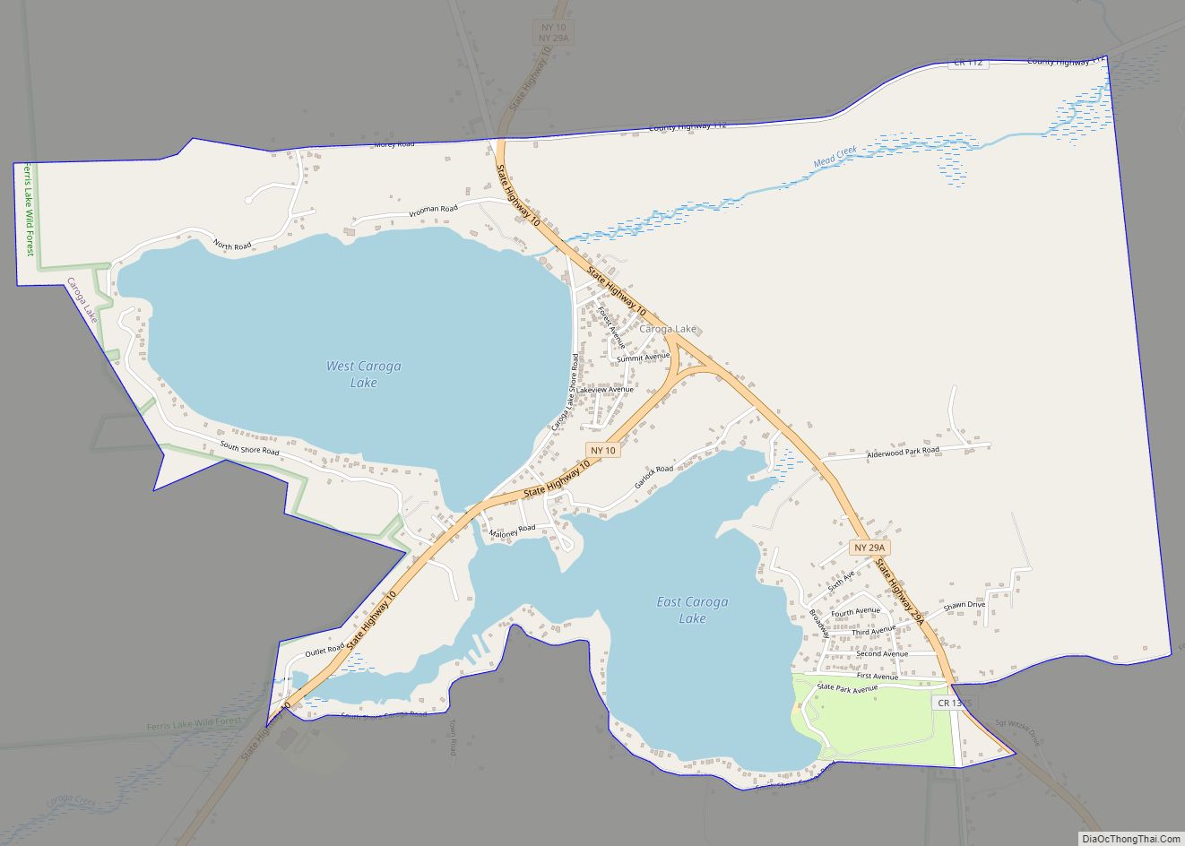
Caroga Lake is an unincorporated community and census-designated place (CDP) in the town of Caroga, Fulton County, New York, United States. The population was 518 at the 2010 census. The hamlet is in the southern part of the town of Caroga and is northwest of Gloversville. Two lakes, West Caroga Lake and East Caroga Lake ... Read more
Map of Caroga Lake CDP
Map of Carmel Hamlet CDP
Carmel Hamlet CDP overview: Name: Carmel Hamlet CDP LSAD Code: 57 LSAD Description: CDP (suffix) State: New York County: Putnam County FIPS code: 3612532 Online Interactive Map Carmel Hamlet online map. Source: Basemap layers from Google Map, Open Street Map (OSM), Arcgisonline, Wmflabs. Boundary Data from Database of Global Administrative Areas. Carmel Hamlet location map. ... Read more
Map of Carmel Hamlet CDP
Map of Carle Place CDP
Carle Place (also known historically as Frog Hollow and Mineola Park) is a hamlet and census-designated place (CDP) in the Town of North Hempstead in Nassau County, on Long Island, in New York, United States. The CDP’s population was 4,981 at the 2010 census. Carle Place CDP overview: Name: Carle Place CDP LSAD Code: 57 ... Read more
Map of Carle Place CDP
Map of Cape Vincent village
Cape Vincent is a village in Jefferson County, New York, United States. The population was 726 at the 2010 census. The village is in the west-central part of the town of Cape Vincent and is northwest of Watertown. Cape Vincent village overview: Name: Cape Vincent village LSAD Code: 47 LSAD Description: village (suffix) State: New ... Read more
Map of Cape Vincent village
Map of Canton village, New York
Canton is a village and county seat of St. Lawrence County, New York, United States. The village is centrally located in both the town of Canton and the county of St. Lawrence. The population was 7,155 at the 2020 census. The name comes from the Chinese city of Canton (now Guangzhou). The village of Canton ... Read more
Map of Canton village, New York
Map of Canisteo village
Canisteo (/ˌkænɪsˈtiːoʊ/) is a village in Steuben County, New York, United States. The population was 2,270 at the 2010 census. The Village of Canisteo is in the northwest corner of the Town of Canisteo and is southeast of Hornell. Canisteo village overview: Name: Canisteo village LSAD Code: 47 LSAD Description: village (suffix) State: New York ... Read more
Map of Canisteo village
Map of Candor village, New York
Candor is a village located in the Town of Candor in Tioga County, New York, United States. The population was 851 at the 2010 census. It is part of the Binghamton Metropolitan Statistical Area. The Village of Candor is centrally located in the town and is south of Ithaca. Candor village overview: Name: Candor village ... Read more
Map of Candor village, New York
Map of Cayuga Heights village
Cayuga Heights is a village in Tompkins County, New York, United States, and an upscale suburb of Ithaca. The population was 4,114 at the 2020 census. The Village of Cayuga Heights is in the Town of Ithaca, directly northeast of the City of Ithaca and the main campus of Cornell University. The village is home ... Read more
Map of Cayuga Heights village
Map of Cattaraugus village
Cattaraugus is a village in Cattaraugus County, New York, United States. The population was 996 at the 2020 census. The village lies in the northeast part of the town of New Albion, north of Salamanca. Cattaraugus village overview: Name: Cattaraugus village LSAD Code: 47 LSAD Description: village (suffix) State: New York County: Cattaraugus County Elevation: ... Read more
Map of Cattaraugus village
Map of Catskill village
Catskill is a village and county seat of Greene County, New York, United States. The population was 4,081 at the 2010 census, down from 4,392 in 2000. The village is in the northeastern part of the town of Catskill. Catskill village overview: Name: Catskill village LSAD Code: 47 LSAD Description: village (suffix) State: New York ... Read more
Map of Catskill village