Map of Scarsdale village
Scarsdale is a town and village in Westchester County, New York, United States. The Town of Scarsdale is coextensive with the Village of Scarsdale, but the community has opted to operate solely with a village government, one of several villages in the state that have a similar governmental situation. As of the 2020 census, Scarsdale’s ... Read more
Map of Scarsdale village
Map of Sayville CDP
Sayville is a hamlet and census-designated place in Suffolk County, New York, United States. Located on the South Shore of Long Island in the Town of Islip, the population of the CDP was 16,853 at the time of the 2010 census. Sayville CDP overview: Name: Sayville CDP LSAD Code: 57 LSAD Description: CDP (suffix) State: ... Read more
Map of Sayville CDP
Map of Savona village
Savona is a village in Steuben County, New York, United States. The population was 827 at the 2010 census. The village is named after Savona in Italy. The Village of Savona is located in the eastern part of the Town of Bath. The village is located at the intersection of Routes 226, 415, and Interstate ... Read more
Map of Savona village
Map of Savannah CDP, New York
Savannah is a hamlet (and census-designated place) located in the Town of Savannah, Wayne County, New York, United States. The population was 558 at the 2010 census. Savannah was incorporated as a village in 1867, but dissolved in 1979. Government offices for the Town of Savannah are located in the hamlet. Savannah CDP overview: Name: ... Read more
Map of Savannah CDP, New York
Map of Saugerties village
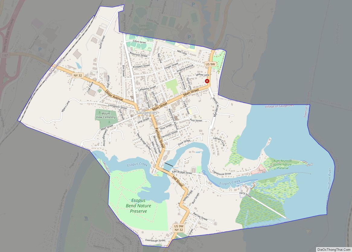
Saugerties (/ˈsɔːɡərtiːz/) is a village in Ulster County, New York, United States. The population was 3,899 at the 2020 census, showing a slight decline from the 3,971 counted at the 2010 census. The Village of Saugerties is located on the west bank of the Hudson River, at the mouth of the Esopus Creek. It is ... Read more
Map of Saugerties village
Map of Saugerties South CDP
Saugerties South is a hamlet (and census-designated place) in Ulster County, New York, United States. The population was 2,442 at the 2020 census. Saugerties South is a community south of the Village of Saugerties and Esopus Creek in the Town of Saugerties. U.S. Route 9W passes through the community. Saugerties South CDP overview: Name: Saugerties ... Read more
Map of Saugerties South CDP
Map of Saratoga Springs city, New York
Saratoga Springs is a city in Saratoga County, New York, United States. The population was 28,491 at the 2020 census. The name reflects the presence of mineral springs in the area, which has made Saratoga a popular resort destination for over 200 years. It is home to the Saratoga Race Course, a thoroughbred horse racing ... Read more
Map of Saratoga Springs city, New York
Map of Sea Cliff village
Sea Cliff is a village located within the Town of Oyster Bay in Nassau County, on Long Island, in New York, United States. As of the 2010 United States census, the village population was 4,995. It is considered part of the greater Glen Cove area, which is anchored by the City of Glen Cove. Sea ... Read more
Map of Sea Cliff village
Map of Scottsville village, New York
Scottsville is a village in southwestern Monroe County, New York, United States, and is in the northeastern part of the Town of Wheatland. The population was 2,001 at the 2010 census. The village is named after an early settler, Isaac Scott. Most Scottsvillians work in and around the city of Rochester—the village of Scottsville is ... Read more
Map of Scottsville village, New York
Map of Scottsburg CDP, New York
Scottsburg is a hamlet and census-designated place (CDP) in Livingston County, New York, United States. Its population was 117 as of the 2010 census. New York State Route 256 passes through the community. Scottsburg CDP overview: Name: Scottsburg CDP LSAD Code: 57 LSAD Description: CDP (suffix) State: New York County: Livingston County Elevation: 925 ft (282 m) ... Read more
Map of Scottsburg CDP, New York
Map of Scotts Corners CDP
Scotts Corners is a hamlet (and census-designated place or CDP) located in the town of Pound Ridge in Westchester County, New York, United States. As of the 2010 census, the CDP population was 711, making Scotts Corners Westchester County’s smallest census-recognized area. Scotts Corners is near the southern town line (the border of Connecticut), east ... Read more
Map of Scotts Corners CDP
Map of Scotia village, New York
Scotia is a village in Schenectady County, New York, United States, incorporated in 1904. The population was 7,729 at the 2010 census. Scotia is part of the town of Glenville, and is connected with the city of Schenectady by the Western Gateway Bridge over the Mohawk River. Scotia village overview: Name: Scotia village LSAD Code: ... Read more
Map of Scotia village, New York