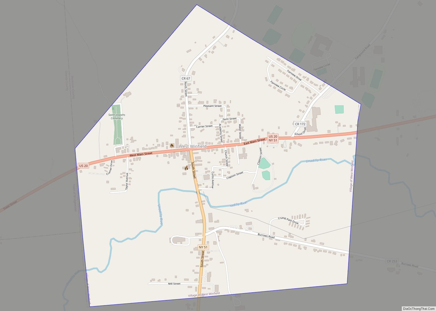
Map of Westmere CDP

Map of Westmere CDP

Westmere is a hamlet in the town of Guilderland, Albany County, New York, United States. Since the 1970 Census, a census-designated place (CDP) has been established with the name of Westmere for tabulating the population of what the census has defined as the boundaries for Westmere. The population was 7,284 at the 2010 census. It … Read more

Map of Wilmington CDP, New York

Map of Wilmington CDP, New York

Wilmington is a hamlet and census-designated place (CDP) in the town of Wilmington in Essex County, New York, United States. The population of the CDP was 937 at the 2010 census, out of a total town population of 1,253. Wilmington CDP overview: Name: Wilmington CDP LSAD Code: 57 LSAD Description: CDP (suffix) State: New York … Read more

Map of Willsboro CDP

Map of Willsboro CDP

Willsboro is a hamlet and census-designated place (CDP) in the town of Willsboro in Essex County, New York, United States. The population of the CDP was 753 at the 2010 census, out of a total town population of 2,025. Willsboro CDP overview: Name: Willsboro CDP LSAD Code: 57 LSAD Description: CDP (suffix) State: New York … Read more

Map of Williston Park village

Map of Williston Park village

Williston Park is an incorporated village in the Town of North Hempstead in Nassau County, on Long Island, in New York, United States. The population was 7,287 at the 2010 census. Williston Park village overview: Name: Williston Park village LSAD Code: 47 LSAD Description: village (suffix) State: New York County: Nassau County Incorporated: 1926 Elevation: … Read more

Map of Williamsville village, New York

Map of Williamsville village, New York

Williamsville is a village in Erie County, New York, United States. The population was 5,423 at the 2020 census. The village is named after Jonas Williams, an early settler. It is part of the Buffalo–Niagara Falls Metropolitan Statistical Area. Williamsville is located mostly within the town of Amherst, but Creek Road and Creek Heights in … Read more

Map of Williamson CDP, New York

Map of Williamson CDP, New York

Williamson is a hamlet (and census-designated place) located in the Town of Williamson, Wayne County, New York, United States. The population was 2,495 at the 2010 census. Government offices for the Town of Williamson are located in the hamlet. Williamson hosts the annual Apple Blossom Festival in the hamlet each May. Williamson CDP overview: Name: … Read more

Map of Whitney Point village

Map of Whitney Point village

Whitney Point is a village in Broome County, New York, United States. The population was 964 at the 2010 census. It is part of the Binghamton Metropolitan Statistical Area. The name comes from Thomas and William Whitney, early developers. The village is in the southwestern corner of the town of Triangle and is north of … Read more

Map of Whitesboro village, New York

Map of Whitesboro village, New York

Whitesboro is a village in Oneida County, New York, United States. The population was 3,772 at the 2010 census. The village is named after Hugh White, an early settler. The Village of Whitesboro is inside the Town of Whitestown. Whitesboro village overview: Name: Whitesboro village LSAD Code: 47 LSAD Description: village (suffix) State: New York … Read more

Map of Whitehall village, New York

Map of Whitehall village, New York

Whitehall is a village located in the town of Whitehall in Washington County, New York, United States. It is part of the Glens Falls Metropolitan Statistical Area. The village population was 2,614 in 2010. The village of Whitehall is located at the point where the Vermont border connects to the southern end of Lake Champlain. … Read more

Map of White Plains city, New York

Map of White Plains city, New York

White Plains is a city in Westchester County, New York, United States. It is the eleventh-largest city in the state of New York, an outer suburb of New York City, and the county seat and commercial hub of Westchester County, a densely populated suburban county that is home to approximately one million people. White Plains … Read more

Map of Wheatley Heights CDP

Map of Wheatley Heights CDP

Wheatley Heights is a census-designated place (CDP) in Suffolk County, New York. The population was 5,130 at the 2010 census. The CDP, located in the Town of Babylon, is named after the hamlet in the same general vicinity. In the past, some or all Wheatley Heights was proposed to become part of the never-realized Incorporated … Read more

Map of Wilson village, New York

Map of Wilson village, New York

Wilson is a town in Niagara County, New York, United States. The population was 5,993 at the 2010 census. The town was named after an early settler, Reuben Wilson, who built and dwelt in a log cabin on the shore of Lake Ontario at the site of what would become the Village of Wilson. The … Read more