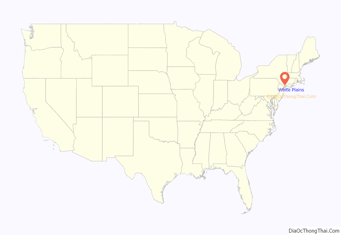
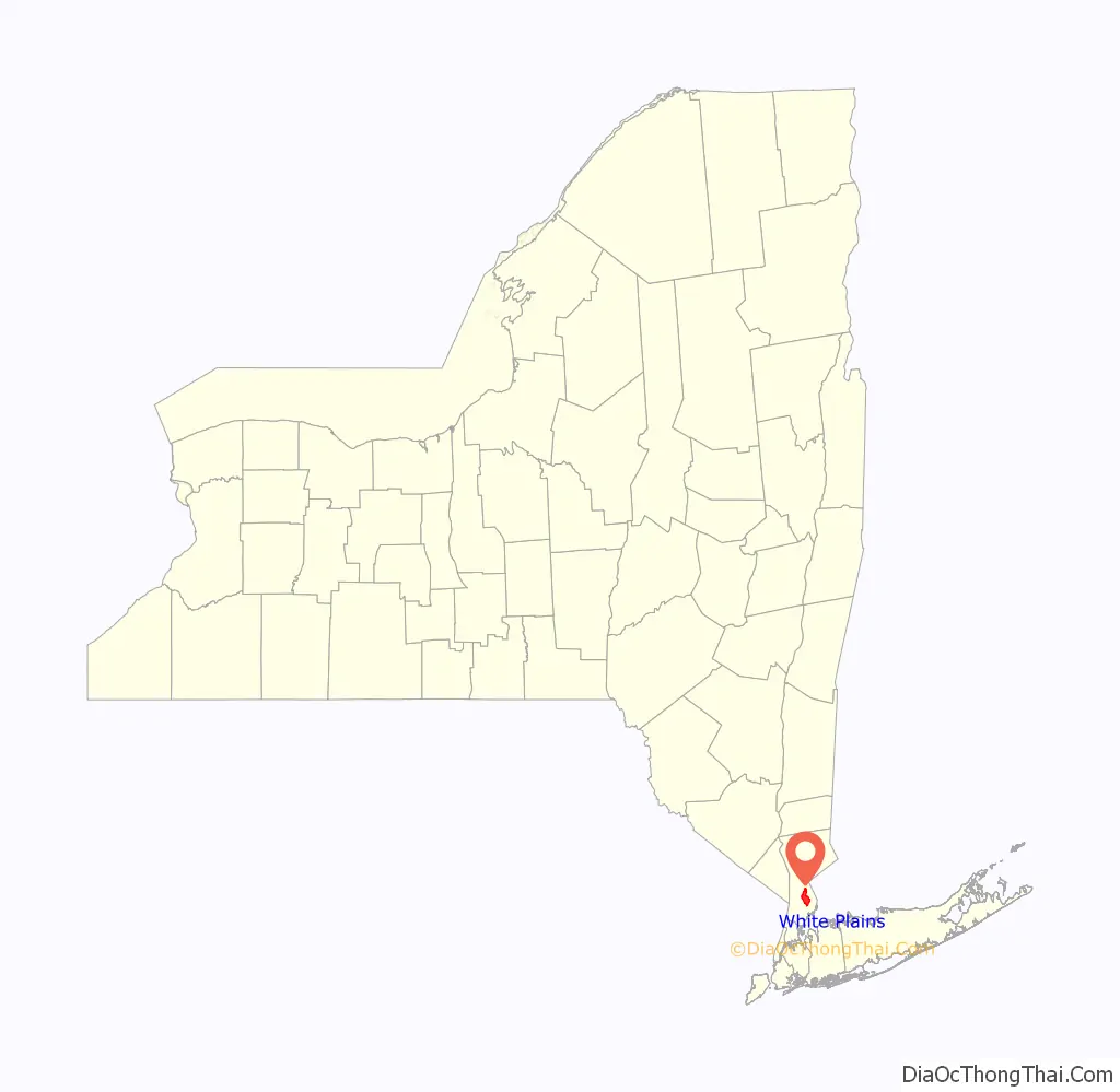
White Plains is a city in Westchester County, New York, United States. It is the eleventh-largest city in the state of New York, an outer suburb of New York City, and the county seat and commercial hub of Westchester County, a densely populated suburban county that is home to approximately one million people. White Plains is located in south-central Westchester County. Its downtown (Mamaroneck Avenue) is 25 miles (40 km) north of Midtown Manhattan.
The city’s total population was 59,599 in the 2020 census, up from 53,077 at the 2010 census. According to the city government, the daytime weekday population is estimated at 250,000. The city was ranked third in the top 10 places to live in New York for 2014, according to national online real estate brokerage Movoto.
| Name: | White Plains city |
|---|---|
| LSAD Code: | 25 |
| LSAD Description: | city (suffix) |
| State: | New York |
| County: | Westchester County |
| Elevation: | 213 ft (65 m) |
| Total Area: | 9.86 sq mi (25.54 km²) |
| Land Area: | 9.74 sq mi (25.22 km²) |
| Water Area: | 0.12 sq mi (0.32 km²) |
| Total Population: | 59,559 |
| Population Density: | 6,116.77/sq mi (2,361.77/km²) |
| Area code: | 914 |
| FIPS code: | 3681677 |
| GNISfeature ID: | 0977432 |
| Website: | www.cityofwhiteplains.com |
Online Interactive Map
Click on ![]() to view map in "full screen" mode.
to view map in "full screen" mode.
White Plains location map. Where is White Plains city?
History
Early history
At the time of the Dutch settlement of Manhattan in the early 17th century, the region had been used as farmland by the Weckquaeskeck tribe, a Wappinger people, and was called “Quarropas”. To early traders it was known as “the White Plains”, either from the white balsam (Gnaphalium polycephalum) which was said to have covered it, or from the heavy mist that local tradition suggests hovered over the swamplands near the Bronx River. The first non-native settlement came in November 1683, when a party of Connecticut Puritans moved westward from an earlier settlement in Rye and bought about 4,400 acres (18 km), presumably from the Weckquaeskeck. However, John Richbell of Mamaroneck claimed to have earlier title to much of the territory through his purchase of a far larger plot extending 20 miles (32 km) inland, perhaps from a different tribe. The matter was not settled until 1721, when a Royal Patent for White Plains was granted by King George II.
In 1758, White Plains became the seat of Westchester County when the colonial government for the county left West Chester, which was located in what is now the northern part of the borough of the Bronx, in New York City. The unincorporated village remained part of the Town of Rye until 1788 when the town of White Plains was created.
On July 9, 1776, a copy of the Declaration of Independence was delivered to the New York Provincial Congress, which was meeting in the county courthouse. The delegates quickly adopted a resolution approving the Declaration, thus declaring both the colony’s independence and the formation of the State of New York. The Declaration itself was first publicly read from the steps of the courthouse on July 11.
During September and October 1776, troops led by George Washington took up positions in the hills of the village, hotly pursued by the British under General Sir William Howe, who attacked on October 28. The Battle of White Plains took place primarily on Chatterton Hill, (later known as “Battle Hill,” and located just west of what was then a swamp but is now the downtown area) and the Bronx River. Howe’s force of 4,000–6,000 British and Hessian soldiers required three attacks before the Continentals, numbering about 1,600 under the command of Generals Alexander McDougall and Israel Putnam, retreated, joining Washington’s main force, which did not take part in the battle. Howe’s forces had suffered 250 casualties, a severe loss, and he made no attempt to pursue the Continentals, whose casualties were about 125 dead and wounded. Three days after the battle Washington withdrew north of the village, which was then occupied by Howe’s forces. But after several inconclusive skirmishes over the next week Howe withdrew on November 5, leaving White Plains to the Continentals. Ironically, one of Washington’s subordinates, Major John Austin, who was probably drunk after having celebrated the enemy’s withdrawal, reentered the village with his detachment and proceeded to burn it down. Although he was court-martialed and convicted for this action, he escaped punishment.
The first United States Census, conducted in 1790, listed the White Plains population at 505, of whom 46 were slaves. (New York City’s population at that time was about 33,000.) By 1800, the population stood at 575 and in 1830, 830. By 1870, 26 years after the arrival of the New York Central Railroad, it had swollen to 2,630 and by 1890 to 4,508. In the decades that followed the count grew to 7,899 (1900) and 26,425 (1910). White Plains was incorporated as a village in 1866 and as a city in 1916.
Modern history
Following World War II, White Plains’ downtown area developed into what amounted to a “destination” shopping district featuring branch stores of many famous New York-based department and specialty stores. Some of these retail locations were the first large-scale suburban stores built in the United States and ushered in the eventual post-war building boom. Construction of nearby parkways and expressways in the 1940s through the 1970s only enhanced White Plains’ role as a retail location. With a city opening ceremony, Macy’s launched a grand White Plains store on Main Street across from City Hall in 1949. As the mayor said at the time, this was a significant event in the life of White Plains. Other prestigious stores followed, such as B. Altman and Co., Rogers Peet, Saks Fifth Avenue, Lord & Taylor, Alexander’s, Wallachs, and a short-lived branch of Bergdorf Goodman, which was converted to sister chain Neiman Marcus in 1981. White Plains is still a huge retail destination in the area with Bloomingdale’s, Neiman Marcus, Nordstrom, Nordstrom Rack, Macy’s, Burlington Coat Factory, and over 1,000 other small and mid-size stores in two malls.
During the late 1960s, the city of White Plains developed an extensive urban renewal plan for residential, commercial and mixed-use redevelopment that effectively called for the demolition of its entire central business district from the Bronx River Parkway east to Mamaroneck Avenue. By 1978, the urban renewal program centered around the construction of the Westchester County Courthouse (1974), the Westchester One office building (1975), the Galleria at White Plains mall (1978), and a number of other office towers, retail centers and smaller commercial buildings.
At the time of its construction, the Westchester One building was the largest office building between New York City and Albany, and east to Hartford.
Beginning in the 1950s, many major corporations based in New York City relocated operations to White Plains and other suburban locations. These included General Foods, PepsiCo, Hitachi USA, IBM, Nestlé, Snapple and Heineken USA. At the height of the 1980s, at least 50 Fortune 500 corporations called Westchester County and nearby Fairfield County, Connecticut, home, but with the corporate mergers and downsizing of the 1990s many of these companies either reduced their operations in White Plains or left the area completely.
White Plains continues to attract regional and national business as well as international headquarters within its boundaries such as Nine West Group, Allegiance Financial, ITT Corporation, Nokia, Heineken USA, Alliance Bernstein, AT&T and Verizon.
White Plains is also home to the Arts Exchange Building, which serves as the headquarters of the Westchester Arts Council. Since March 1999, visual and performing artists, emerging cultural organizations and new creative businesses have had studios and offices in the building. It is listed on the National Register of Historic Places.
The construction of the Galleria at White Plains mall in the 1970s ushered in a new era of downtown retail and office development, but by the early 1990s, economic development had stagnated, hampered by a deep recession and the overbuilding of the commercial real estate markets. For a time, White Plains had the dubious distinction of having one of the highest office vacancy rates in the northeastern United States. Consolidation within the retail industry led to the closing of many of downtown’s original department and specialty stores as well. After its bankruptcy, the B. Altman store closed in 1989 and was eventually demolished to make way for the massive upscale retail mall, The Westchester, which opened in 1995 with anchors Nordstrom and Neiman Marcus. A freestanding branch of Macy’s, one of downtown’s original retail anchor stores, was relocated two blocks away to The Galleria mall by its parent company, Federated Department Stores, replacing the location of sister retailer Abraham & Straus when these two store divisions were merged in 1995.
In early 2003, the Saks Fifth Avenue location was also closed and demolished; it was replaced in 2004 with the large retail complex called The Source at White Plains, featuring the upscale restaurants Morton’s of Chicago, The Cheesecake Factory, and the gourmet supermarket chain Whole Foods Markets. Note: As of July 20, 2009, the Fortunoff and Mayrock families re-acquired the Fortunoff brand and intellectual property; all Fortunoff stores are currently closed. On August 9, 2018, the 180,000-square-foot (17,000 m) Walmart at 275 S Main St. (one of only two in Westchester County) was closed due to lack of convenience.
Other major projects were completed in the late 1990s and early 2000s that have further altered the urban character of downtown White Plains. A new courthouse for the Southern District of New York was opened in 1998 and several large-scale office properties in and near downtown, including the former General Foods headquarters building, were retrofitted and leased to accommodate smaller businesses. The Macy’s store on Main Street remained vacant for several years until it was also later demolished to make way for the massive City Center at White Plains complex. This large mixed-use development features two 35-story apartment and condominium towers, 600,000-square-foot (60,000 m) of retail, restaurant and entertainment space and new parking facilities. Aside from the Arts Exchange building (which used to be a bank), another bank next to the City Center was renovated to become Zanaro’s, a family-style Italian restaurant. Buffalo Wild Wings replaced Zanaro’s upon its 2010 closure. City Center’s opening in 2003 marked the beginning of a new downtown development renaissance, with an improving economy and healthy office leasing activity.
In 2007, construction was completed on Renaissance Square, a downtown parcel that includes the luxury Ritz-Carlton hotel.
Beginning in 2000, the city’s permanent population experienced a growth spurt as additional apartment buildings were constructed. The city is 31 minutes by express train from Midtown Manhattan, and this has attracted new residents who commute to New York City for work. However, in large part because of its proximity to New York City, the cost of living in White Plains, although lower than that of New York City itself, is by some measures among the highest in the world. White Plains is also the home to the United States Tennis Association USTA B team.
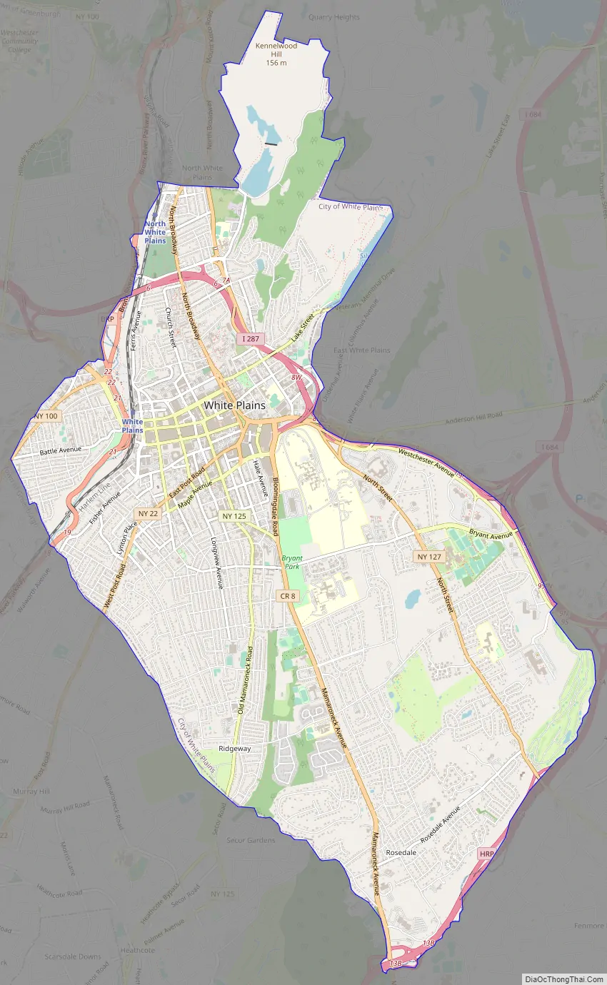
White Plains Road Map
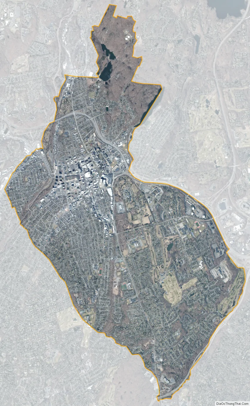
White Plains city Satellite Map
Geography
White Plains is bordered to the north by the town of North Castle, to the north and east by the town/village of Harrison, to the south by the town/village of Scarsdale, and to the west by the town of Greenburgh. The city is about 7 miles (11 km) east of the Hudson River and 7 miles (11 km) northwest of the Long Island Sound. According to the U.S. Census Bureau, White Plains has a land area of 9.77 square miles (25.3 km), and a population density of 5,820.3 inhabitants per square mile (2,247.2/km).
Climate
White Plains has a humid continental climate, with four distinct seasons. Winter is cold and wet, with occasional snow and an average January temperature of 29.8 °F (−1.2 °C), and summer is hot and humid, with a mean July temperature of 74.0 °F (23.3 °C). In spring and fall, temperatures can fluctuate from cool to hot, but are usually mild and comfortable. Precipitation is plentiful in all months of the year. The city receives approximately 229 clear or partly cloudy days per annum, with July typically being the sunniest month, averaging more than 70 percent of possible sunshine.
The lowest temperature ever recorded in White Plains since record-keeping began in 1948 was −10 °F (−23 °C) on January 19, 1977, and the highest ever was 102 °F (39 °C) on July 6, 2010. Over the course of a typical year, there are 18 days of at least 90 °F (32 °C) temperatures, and seven days when temperatures do not rise above the freezing point.
Tallest buildings
Neighborhoods
White Plains has 35 neighborhoods:
- Battle Hill
- Bryant Gardens
- Carhart
- Colonial Corners
- Downtown White Plains
- East White Plains
- Eastview
- Ferris Avenue
- Fisher Hill
- Fulton Street
- Gedney Farms
- Gedney Manor
- Gedney Meadows
- Gedney Park
- Green Acres
- Haviland Manor
- Highlands
- Holbrooke
- Idle Forest
- North Broadway
- North Street
- North White Plains
- Dekalb
- Old Mamaroneck Road
- Prospect Park
- Reynal Park
- Ridgeway
- Rocky Dell
- Rosedale
- Saxon Woods
- Secor Gardens
- Westminster Ridge
- Winbrook
- Woodcrest Heights
Parks and recreation
- Ebersole Ice Rink
- Maple Moor Golf Course
- Saxon Woods Park provides a range of recreational amenities, including trails, a standard and miniature golf course, and the largest swimming pool in Westchester.
- Silver Lake Preserve
- Westchester Golf Range
See also
Map of New York State and its subdivision:- Albany
- Allegany
- Bronx
- Broome
- Cattaraugus
- Cayuga
- Chautauqua
- Chemung
- Chenango
- Clinton
- Columbia
- Cortland
- Delaware
- Dutchess
- Erie
- Essex
- Franklin
- Fulton
- Genesee
- Greene
- Hamilton
- Herkimer
- Jefferson
- Kings
- Lake Ontario
- Lewis
- Livingston
- Madison
- Monroe
- Montgomery
- Nassau
- New York
- Niagara
- Oneida
- Onondaga
- Ontario
- Orange
- Orleans
- Oswego
- Otsego
- Putnam
- Queens
- Rensselaer
- Richmond
- Rockland
- Saint Lawrence
- Saratoga
- Schenectady
- Schoharie
- Schuyler
- Seneca
- Steuben
- Suffolk
- Sullivan
- Tioga
- Tompkins
- Ulster
- Warren
- Washington
- Wayne
- Westchester
- Wyoming
- Yates
- Alabama
- Alaska
- Arizona
- Arkansas
- California
- Colorado
- Connecticut
- Delaware
- District of Columbia
- Florida
- Georgia
- Hawaii
- Idaho
- Illinois
- Indiana
- Iowa
- Kansas
- Kentucky
- Louisiana
- Maine
- Maryland
- Massachusetts
- Michigan
- Minnesota
- Mississippi
- Missouri
- Montana
- Nebraska
- Nevada
- New Hampshire
- New Jersey
- New Mexico
- New York
- North Carolina
- North Dakota
- Ohio
- Oklahoma
- Oregon
- Pennsylvania
- Rhode Island
- South Carolina
- South Dakota
- Tennessee
- Texas
- Utah
- Vermont
- Virginia
- Washington
- West Virginia
- Wisconsin
- Wyoming


