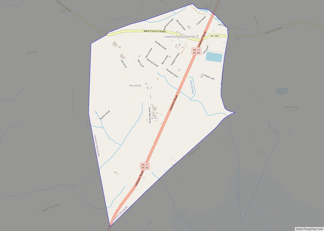
Map of Leland town, North Carolina
Leland is the most populous town in Brunswick County, North Carolina, United States. The population was 23,504 at the 2020 census, up from 13,527 in 2010. As of 2020, it is considered to be one of the fastest growing towns in North Carolina. It is part of the Myrtle Beach Metropolitan Statistical Area. and the ... Read more
Map of Leland town, North Carolina
Map of Leggett town, North Carolina
Legett is a town in Edgecombe County, North Carolina, United States. It is part of the Rocky Mount, North Carolina Metropolitan Statistical Area. The population was 37 in the 2020 Census. Leggett town overview: Name: Leggett town LSAD Code: 43 LSAD Description: town (suffix) State: North Carolina County: Edgecombe County Elevation: 59 ft (18 m) Total Area: ... Read more
Map of Leggett town, North Carolina
Map of Lawndale town, North Carolina
Lawndale is a town in Cleveland County, North Carolina, United States, situated along the First Broad River. The population was 606 at the 2010 census. Lawndale town overview: Name: Lawndale town LSAD Code: 43 LSAD Description: town (suffix) State: North Carolina County: Cleveland County Elevation: 846 ft (258 m) Total Area: 0.86 sq mi (2.23 km²) Land Area: 0.81 sq mi (2.09 km²) ... Read more
Map of Lawndale town, North Carolina
Map of Lilesville town
Lilesville is a town in Anson County, North Carolina, United States. The population was 404 at the 2020 census. Lilesville town overview: Name: Lilesville town LSAD Code: 43 LSAD Description: town (suffix) State: North Carolina County: Anson County Founded: 1827 Incorporated: 1874 Elevation: 499 ft (152 m) Total Area: 0.99 sq mi (2.57 km²) Land Area: 0.99 sq mi (2.57 km²) Water Area: ... Read more
Map of Lilesville town
Map of Light Oak CDP
Light Oak is an unincorporated area and census-designated place (CDP) in Cleveland County, North Carolina, United States. The population was 691 at the 2010 census. Light Oak CDP overview: Name: Light Oak CDP LSAD Code: 57 LSAD Description: CDP (suffix) State: North Carolina County: Cleveland County Elevation: 837 ft (255 m) Total Area: 1.44 sq mi (3.72 km²) Land Area: ... Read more
Map of Light Oak CDP
Map of Liberty town, North Carolina
Liberty is a town in Randolph County, North Carolina, United States. Liberty town overview: Name: Liberty town LSAD Code: 43 LSAD Description: town (suffix) State: North Carolina County: Randolph County Elevation: 784 ft (239 m) Total Area: 3.15 sq mi (8.15 km²) Land Area: 3.13 sq mi (8.11 km²) Water Area: 0.01 sq mi (0.03 km²) Total Population: 2,655 Population Density: 847.70/sq mi (327.27/km²) ZIP code: 27298 ... Read more
Map of Liberty town, North Carolina
Map of Lowesville CDP
Lowesville is a census-designated place (CDP) in Lincoln County, North Carolina, United States. The population was 2,945 at the 2010 census, up from 1,440 in 2000. Lowesville CDP overview: Name: Lowesville CDP LSAD Code: 57 LSAD Description: CDP (suffix) State: North Carolina County: Lincoln County Elevation: 804 ft (245 m) Total Area: 6.80 sq mi (17.62 km²) Land Area: 6.79 sq mi ... Read more
Map of Lowesville CDP
Map of Lowell city, North Carolina
Lowell is a small city in Gaston County, North Carolina, United States, located east of Gastonia. The population was 3,526 at the 2010 census. Lowell city overview: Name: Lowell city LSAD Code: 25 LSAD Description: city (suffix) State: North Carolina County: Gaston County Incorporated: 1879 Elevation: 817 ft (249 m) Total Area: 3.68 sq mi (9.53 km²) Land Area: 3.67 sq mi ... Read more
Map of Lowell city, North Carolina
Map of Love Valley town
Love Valley is a town in Iredell County, North Carolina, United States. It also extends into Alexander County on its western end. The population was 90 at the 2010 census, and in 2020 the estimated population was 154. Love Valley town overview: Name: Love Valley town LSAD Code: 43 LSAD Description: town (suffix) State: North ... Read more
Map of Love Valley town
Map of Louisburg town, North Carolina
Louisburg is a town in Franklin County, North Carolina, United States. As of the 2020 census, the town population was 3,064. It is the county seat of Franklin County. The town is located approximately 29 miles northeast of the state capital, Raleigh, and located about 31 miles south of the Virginia border. It is also ... Read more
Map of Louisburg town, North Carolina
Map of Long View town
Long View is a town in Burke and Catawba counties in the U.S. state of North Carolina. The population was 4,871 at the 2010 census. It is part of the Hickory–Lenoir–Morganton Metropolitan Statistical Area. Long View town overview: Name: Long View town LSAD Code: 43 LSAD Description: town (suffix) State: North Carolina County: Burke County, ... Read more
Map of Long View town
Map of Locust city
Locust is a small rural city in Stanly and Cabarrus counties in the U.S. state of North Carolina. The population was 2,930 at the 2010 census. Locust city overview: Name: Locust city LSAD Code: 25 LSAD Description: city (suffix) State: North Carolina County: Cabarrus County, Stanly County Elevation: 719 ft (219 m) Total Area: 8.19 sq mi (21.21 km²) Land ... Read more
Map of Locust city