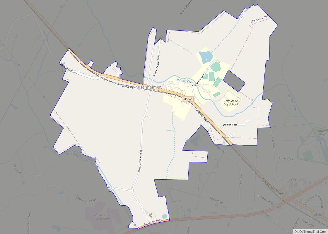
Map of Mint Hill town
Mint Hill is a suburban town in southeastern Mecklenburg and northwestern Union counties in the U.S. state of North Carolina, it is a major suburb on the outskirts of Charlotte and near the Cabarrus County line. The population was 22,722 at the 2010 census. Mint Hill town overview: Name: Mint Hill town LSAD Code: 43 ... Read more
Map of Mint Hill town
Map of Minnesott Beach town
Minnesott Beach is a town in Pamlico County, North Carolina, United States. The population was 440 at the 2010 census. It is part of the New Bern, North Carolina Micropolitan Statistical Area. Minnesott Beach town overview: Name: Minnesott Beach town LSAD Code: 43 LSAD Description: town (suffix) State: North Carolina County: Pamlico County Elevation: 3 ft ... Read more
Map of Minnesott Beach town
Map of Mineral Springs town, North Carolina
Mineral Springs is a town in Union County, North Carolina, United States. The population was 2,639 at the 2010 census. Mineral Springs town overview: Name: Mineral Springs town LSAD Code: 43 LSAD Description: town (suffix) State: North Carolina County: Union County Elevation: 640 ft (195 m) Total Area: 8.28 sq mi (21.44 km²) Land Area: 8.21 sq mi (21.26 km²) Water Area: 0.07 sq mi ... Read more
Map of Mineral Springs town, North Carolina
Map of Milton town, North Carolina
Milton is a town in Caswell County, North Carolina, United States. The population was 166 at the 2010 census. It is adjacent to the Virginia International Raceway, just across the state line in Virginia. The town’s name was derived from its beginnings as Mill Town. A mill was established prior to the incorporation of the ... Read more
Map of Milton town, North Carolina
Map of Mills River town
Mills River is a town in Henderson County, North Carolina, United States. The population was 6,802 at the 2010 census, and was estimated to be 7,406 in 2019. The town took its name from the nearby confluence of the Mills River and French Broad River. It is part of the Asheville Metropolitan Statistical Area. It ... Read more
Map of Mills River town
Map of Monroe city, North Carolina
Monroe is a city in and the county seat of Union County, North Carolina, United States. The population increased from 32,797 in 2010 to 34,551 in 2020. It is within the rapidly growing Charlotte metropolitan area. Monroe has a council-manager form of government. Monroe city overview: Name: Monroe city LSAD Code: 25 LSAD Description: city ... Read more
Map of Monroe city, North Carolina
Map of Mount Gilead town, North Carolina
Mount Gilead is a town in Montgomery County, in the Piedmont region of North Carolina, United States. The population was 1,181 at the 2010 census. Mount Gilead town overview: Name: Mount Gilead town LSAD Code: 43 LSAD Description: town (suffix) State: North Carolina County: Montgomery County Elevation: 427 ft (130 m) Total Area: 3.49 sq mi (9.04 km²) Land Area: ... Read more
Map of Mount Gilead town, North Carolina
Map of Mount Airy city, North Carolina
Mount Airy /ˈmaʊntəri/ is a city in Surry County, North Carolina, United States. As of the 2020 census, the city population was 10,611. Mount Airy city overview: Name: Mount Airy city LSAD Code: 25 LSAD Description: city (suffix) State: North Carolina County: Surry County Incorporated: 1885 Elevation: 1,115 ft (340 m) Total Area: 11.86 sq mi (30.73 km²) Land Area: ... Read more
Map of Mount Airy city, North Carolina
Map of Morven town, North Carolina
Morven is a town in Anson County, North Carolina, United States. The population was 335 at the 2020 census. The town was named after a town in Argyllshire, Scotland. Morven town overview: Name: Morven town LSAD Code: 43 LSAD Description: town (suffix) State: North Carolina County: Anson County Founded: 1823 Incorporated: 1883 Elevation: 364 ft (111 m) ... Read more
Map of Morven town, North Carolina
Map of Morrisville town, North Carolina
Morrisville is a town located primarily in Wake County, North Carolina, United States (a small portion extends into neighboring Durham County). The U.S. Census Bureau estimated the town’s population to be 31,278 as of July 1, 2021. Morrisville is part of the Research Triangle metropolitan region. The regional name originated after the 1959 creation of ... Read more
Map of Morrisville town, North Carolina
Map of Morganton city, North Carolina
Morganton is a city in and the county seat of Burke County, North Carolina, United States. The population was 16,918 at the 2010 census. Morganton is approximately 75 miles (121 km) northwest of Charlotte. Morganton is one of the principal cities in the Hickory-Lenoir-Morganton, NC Metropolitan Statistical Area. A site five miles north of Morganton has ... Read more
Map of Morganton city, North Carolina
Map of Morehead City town
Morehead City is a port town in Carteret County, North Carolina, United States. The population was 8,661 at the 2010 census. Morehead City celebrated the 150th anniversary of its founding on May 5, 2007. It forms part of the Crystal Coast. Morehead City town overview: Name: Morehead City town LSAD Code: 43 LSAD Description: town ... Read more
Map of Morehead City town