Map of Teachey town

Map of Teachey town

Teachey is a town in Duplin County, North Carolina, United States. Its population was 376 at the 2010 census. Teachey town overview: Name: Teachey town LSAD Code: 43 LSAD Description: town (suffix) State: North Carolina County: Duplin County Elevation: 69 ft (21 m) Total Area: 1.05 sq mi (2.73 km²) Land Area: 1.05 sq mi (2.73 km²) Water Area: 0.00 sq mi (0.00 km²) Total Population: … Read more

Map of Taylortown town

Map of Taylortown town

Taylortown is a town in Moore County, North Carolina, United States. The population was 722 as of the 2010 census. It is bordered by nearby Pinehurst. Taylortown town overview: Name: Taylortown town LSAD Code: 43 LSAD Description: town (suffix) State: North Carolina County: Moore County Elevation: 502 ft (153 m) Total Area: 1.35 sq mi (3.49 km²) Land Area: 1.35 sq mi … Read more

Map of Taylorsville town, North Carolina

Map of Taylorsville town, North Carolina

Taylorsville is a town in Alexander County, North Carolina, United States. The population was 2,098 at the 2010 census. It is the county seat of Alexander County. Taylorsville is part of the Hickory–Lenoir–Morganton Metropolitan Statistical Area. Taylorsville town overview: Name: Taylorsville town LSAD Code: 43 LSAD Description: town (suffix) State: North Carolina County: Alexander County … Read more

Map of Tarboro town

Map of Tarboro town

Tarboro is a town located in Edgecombe County, North Carolina, United States. It is part of the Rocky Mount Metropolitan Statistical Area. As of the 2020 census, the town had a population of 10,721. It is the county seat of Edgecombe County. The town is on the opposite bank of the Tar River from Princeville. … Read more

Map of Tar Heel town

Map of Tar Heel town

Tar Heel is a town located in Bladen County, North Carolina, United States. As of the 2010 census, the town population was 117. Tar Heel is home to the largest pig processing plant in the world, which opened in 1992, operated by Smithfield Foods and is located just north of the town limits. Tar Heel … Read more

Map of Tabor City town

Map of Tabor City town

Tabor City is a town in Columbus County, North Carolina, United States. It is the southernmost town in the county. It is located just north of the North Carolina/South Carolina line, about 39 miles (63 km) north of Myrtle Beach, South Carolina, and is just north of Loris, South Carolina. The population was 2,511 as of … Read more

Map of Sylva town

Map of Sylva town

Sylva is an incorporated town located in central Jackson County, in the Plott Balsam Mountains of Western North Carolina, United States. As of the 2010 census, the town had a total population of 2,588. It is the county seat, taking over the role from nearby Webster in 1913. Sylva town overview: Name: Sylva town LSAD … Read more

Map of Swepsonville town

Map of Swepsonville town

Swepsonville is a town in Alamance County, North Carolina, United States. It is part of the Burlington, North Carolina Metropolitan Statistical Area. The population at the 2010 census was 1,154. Swepsonville town overview: Name: Swepsonville town LSAD Code: 43 LSAD Description: town (suffix) State: North Carolina County: Alamance County Elevation: 525 ft (160 m) Total Area: 1.52 sq mi … Read more

Map of Swansboro town

Map of Swansboro town

Swansboro is a town in Onslow County, North Carolina, United States, located along the Atlantic Ocean. In 2010, the population was 2,663. Swansboro town overview: Name: Swansboro town LSAD Code: 43 LSAD Description: town (suffix) State: North Carolina County: Onslow County Elevation: 16 ft (5 m) Total Area: 2.38 sq mi (6.16 km²) Land Area: 2.23 sq mi (5.79 km²) Water Area: 0.14 sq mi … Read more

Map of Thomasville city, North Carolina

Map of Thomasville city, North Carolina

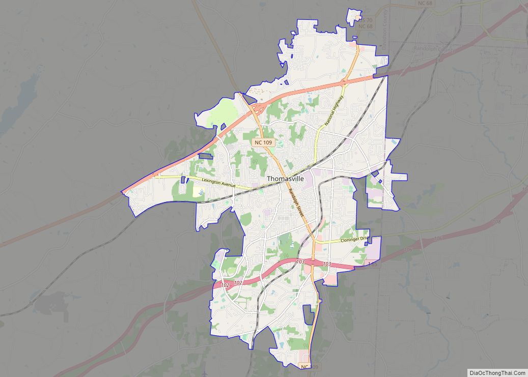
Thomasville is a city in Davidson County, North Carolina, United States. The population was 27,183 at the 2020 census. The city was once notable for its furniture industry, as were its neighbors High Point and Lexington. This Piedmont Triad community was established in 1852 and hosts the state’s oldest festival, “Everybody’s Day”. Thomasville city overview: … Read more

Map of Turkey town

Map of Turkey town, North Carolina

Turkey is a town in Sampson County, North Carolina, United States. The population was 292 at the 2010 census. Turkey town overview: Name: Turkey town LSAD Code: 43 LSAD Description: town (suffix) State: North Carolina County: Sampson County Elevation: 144 ft (44 m) Total Area: 0.40 sq mi (1.03 km²) Land Area: 0.40 sq mi (1.03 km²) Water Area: 0.00 sq mi (0.00 km²) Total Population: … Read more

Map of Tryon town

Map of Tryon town, North Carolina

Tryon is a town in Polk County, on the southwestern border of North Carolina, United States. As of the 2020 census, the city population was 1,562. Located in the escarpment of the Blue Ridge Mountains, today the area is affluent and a center for outdoor pursuits, equestrian activity, and fine arts. Tryon Peak and the … Read more